The sculpture was commissioned as a memorial to the two major floods experienced by Queenstown since European settlement. The sculpture represents a core sample from the area during the most recent flood event.
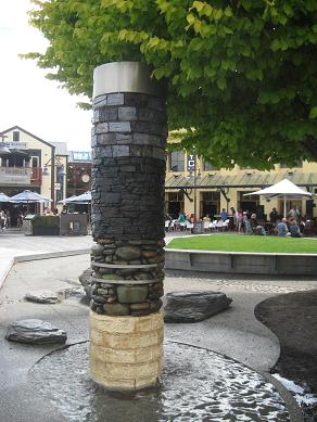
A core sample is a cylindrical section of the earth, mineral, or rock extracted from the ground by means of a special drill called a corer. A geologist can analyse the core sample to determine the composition of rock under the ground. It is nature's time capsule revealing variations of climate, species and sedimentary composition during geologic history.
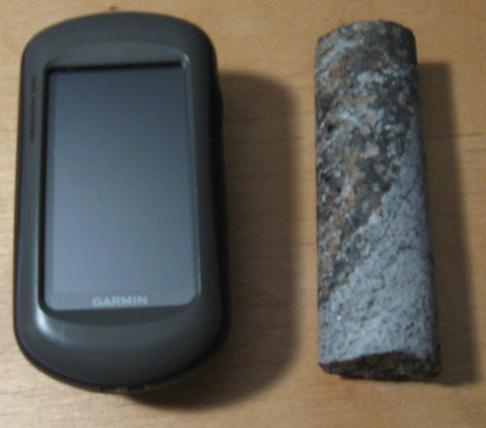
Core samples can be a variety of lengths and diameters depending on their use. The following example is a small piece of a 1" diameter core sample:
Flooding of Lake Wakatipu is a natural process resulting from extended periods of heavy rain and snowmelt in the catchment headwaters. Flooding can occur when more water is flowing into the lake than can flow out. Seven sizeable rivers flow into Lake Wakatipu, and only one flows out – the Kawarau. The largest flood event in recent history caused about 60 million dollars in damage and the town was innundated with water for about two weeks.
At a level of 311.3 metres, Lake Wakatipu begins to flood some Queenstown streets through the stormwater system. The chance of the lake exceeding this level in any one year is 13%. The chance that the lake will exceed this level at least once during any ten year period is 75%.
At a level of 311.6 metres flood waters reach the level of the Steamer Wharf deck. The chance of the lake exceeding this level in any one year is 6%. The chance that the lake will exceed this level at least once during the next ten years is 45%. (Source: Otago Regional Council)
Businesses in Queenstown learnt a lesson all those years ago, and have taken measures to ensure the survival of the local economy should it happen again. Pharmacies have been equipped with movable shelves and the inside of a local pub can be removed like a kitset.
New buildings now have to take flood measures, but the town has generally accepted that as a lakeside resort built on the flood plain, it is a price that must be paid.
Logging Requirements:
Send an email via the profile link with the answers to the following questions:
1. In what year did each of the last two major flood events occur and which one was greater?
2. Name the layers that represent the arrival of the Maori and the time of the gold rush.
If you have a camera available, then please post a photo of yourself or your GPS with the sculpture in the background (optional). Photos of Lake Wakatipu would be appreciated as well.
The sculpture is located in public area which is available 24/7. This EarthCache is wheelchair accessible.
Thanks to KirsTim for providing this image of one of the major flood events memorialized by this sculpture:

EarthCache Supporter