Riesseekalke Hainsfarth

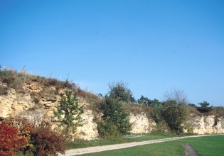
In der Ortschaft Hainsfarth bei Oettingen im Donau-Ries-Kreis gelegen, sind Kalkablagerungen aus dem ehemaligen Riessee zu besichtigen. Dieser hatte sich nach dem Impakt eines Großmeteoriten vor etwa 14,5 Millionen Jahren in dessen Einschlagskrater gebildet. Am Rande des Sees entstanden massige Ablagerungen von fossilführenden Riesseekalken.
Entstehung des Kratersees
Vor etwa 14,5 Millionen Jahren, im Zeitalter des mittleren Miozän, schlug ein großer Meteorit (mit etwa 1 km Durchmesser) in Süddeutschland, im heutigen Donau-Ries, ein. Zurück blieb ein ca. 500 m tiefer Impaktkrater von etwa 25 km Durchmesser. Wasser sammelte sich im abflusslose Becken und es entstand ein überwiegend flacher, ca. 400 km2 große Riessee. Zunächst war dieser stark salzhaltig und nur von Rot- und Braunalgen sowie Kieselalgen (Diatomeen) belebt.
Erst nach dem Wechsel vom semiariden zu zunehmend humidem Klima süßte der See allmählich aus. In der Folge besiedelten nun weitere Lebensformen wie verschiedene Algenarten, Schnecken, Schalenkrebse, Wasservögel und Schilf den Riessee.
Was geschah mit dem Kratersee?
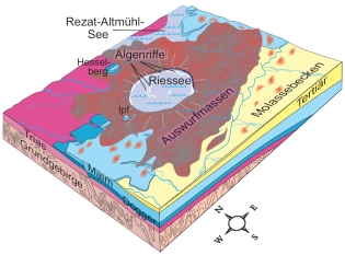
Nach der Kraterentstehung transportierten Schlammströme Schuttmassen vom Rand des Kraters in seinen zentralen Teil, die heute in Form von Konglomeraten und Sandsteinen am Grund des Kraters liegen. Darüber setzten sich vor allem feinkörnige, mehrere Hundert Meter mächtige Seesedimente ab. Gleichzeitig entstanden in flachem Wasser am Ufer und entlang von Untiefen des Riessees Kalkablagerungen durch Algen.
In einem Zeitraum von etwa zwei Millionen Jahren wurde der Krater mit Seesedimenten vollständig aufgefüllt. Sande und Schotter überlagerten das gesamte Gebiet und bedeckten die Sedimente des ehemaligen Kratersees, der Krater war aus der Landschaft verschwunden.
Vor etwa zwei Millionen Jahren, gegen Ende der Tertiär-Zeit, hob sich das Gebiet und die Abtragung der Gesteine setzte ein, so dass die Kraterstruktur wieder frei gelegt wurde. Während die Tone und Tonsteine der Kraterfüllung erodiert wurden, setzten die Riesseekalke der Erosion einen größeren Widerstand entgegen. In der heutigen Landschaft bilden sie oft Höhenrücken.
Das Nördlinger Ries wurde am 12. Mai 2006 als Nationales Geotop ausgezeichnet und erhielt vom Bundesministerium für Bildung und Forschung das Recht, die Plakette "planet erde - Welt der Geowissenschaften" zu verwenden.


Wir würden uns über ein Foto von Dir und Deinem GPS freuen.
Logbedingung:
1. Wie lautet das erste Wort auf dem größeren weiß-blauen Schild am Eingangstor?
2. Welchen Durchmesser hatte der Impaktkrater?
3. Was ist "Hydrobia"?
Sendet die Antworten aus Frage 1 bis 3 an Fam.Weiss mit Eurem GC-Namen (Nickname) in der Betreff-Zeile. Wir melden uns, wenn etwas nicht stimmt.
Achtung - Bitte beachten!
Bitte schreibt die Antworten keinesfalls in Euren Log!
Logeinträge ohne Beantwortung der Fragen werden von mir ohne Nachfrage gelöscht!
Achtung: Je Account ist eine Antwortmail zu senden, um die Logbedingung zu erfüllen! Eine „Sammelantwortmail“ für mehrere Accounts erfüllt daher nur die Logbedingung für den jeweiligen Absender! Die Logs der anderen Accounts werden kommentarlos gelöscht!

Convenient in the locality Hainsfarth with Oettingen in the Donau-Ries, are to be visited lime deposits from the former Riessee. This had formed after the Impact large meteorites approximately 14.5 million year ago in its impact craters. At the edge of the lake massive deposits developed of fossil-prominent Riessee-limes.
Emergence of the crater lake
Approximately 14.5 million years ago, into the age middle Miozän, a large meteorite (with approximately 1 km diameter) knocked into South Germany, in the today's Donau-Ries. Back approx. 500 m of deep Impactcrater by approximately 25 km diameter remained. Water collected itself in dischargeless basins and it developed predominantly flatter, approx. 400 km2 large Riessee. First this was strongly salted and only by red and brown algae as well as flint algae (Diatomeen) encouraged. Only after the change from the semiarid to increasingly humid climate the lake gradually recausticizing. In the consequence now further ways of life settled like different kinds of alga, snails, bowl cancers, water birds and reed the Riessee.
What happened with the crater lake?
To the crater emergence mud streams transported debris masses of the edge of the crater into its central part, which were today in the form of conglomerates and sandstones because of the reason of the crater. Over it above all fine-grained set, several hundred meters powerful sea-sediments off. At the same time lime deposits resulted from algae in flat water on the bank and along the shallows of the Riessee. In one period of approximately two million years the crater with sea-sediments was completely filled up. Sand and crushed stone overlaid the entire area and covered the sediments of the former crater lake, the crater from the landscape had disappeared. Approximately two million years ago, toward end of the Tertiary period time, main header the area and the demolition of the rocks used itself, so that the crater structure was again freely put. While those were eroded clay/tone and clay stones of the crater filling, the Riessee-lime of the erosion opposed a larger resistance. In the today's landscape they often form for elevator backs.
The Nördlinger Ries became to 12. May 2006 as national Geotop excellently and received the right, which plaque from the Federal Ministry for education and research, "planet grounds - world of the geoscience" to use.

We would appreciate a photo of you and your GPS (optional).
Log conditions:
1. How is the first word expressed on the larger white-blue sign at the gate?
2. Which diameter did the Impaktkrater have?
Send the answers of the question 1 to 3 to Fam.Weiss with your GC-name in the subject-line. We contact you if something is wrong.
Attention – Please note!
Please don´'t write the answers into your internet-log at GC!
Log entries without answering the questions will be deleted by us directly without any further enquiry!
Attention: To fulfill the log condition you have to send a reply mail with the answers for the questions per Geocaching account! A "multiple answer mail" for several Geocaching accounts therefore only fulfills the log condition for the respective sender! The logs of the other accounts are deleted without comment!