This event is being held near the Mid
Winter Geocaching
Get-Together 2010
Event Link
We will gather to discuss caching,
winter camping, socialize, and sleep. What other event is it
acceptable and encouraged that you sleep through the event in order
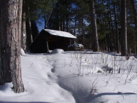
to attend? :-) To log this cache you must sign the log book after
spending the whole night in the leanto with your fellow cachers.
Attendance will be taken, and bed checks may be performed. As there
are other activities in town, the night will be considered as
starting at midnight, until 6 am. You will need to either snowshoe,
ski, or snowmobile to the leanto. You will need winter survival
gear, including but not limited to warm, non cotton clothing, a 4
season sleeping pad, a sleeping bag rated for the temperatures to
be encountered, and a bivy sack or some form of wind and snow
protection for your bag. Bring some high energy fatty snacks, and
everything else you will need to be out in the cold all night long,
including map, compass, flashlights. Make sure someone knows you
are setting out on this 1.2 mile (from trailhead) night hike. You
are welcome to set out early. Many of us may be in town having fun
until late, though. Please post a will attend note if you are
attending, and check back often before setting out on the hike.
This event may be moved or canceled for safety reasons in the case
of severe winter weather. When in town, please check in with me,
GPS Guy.
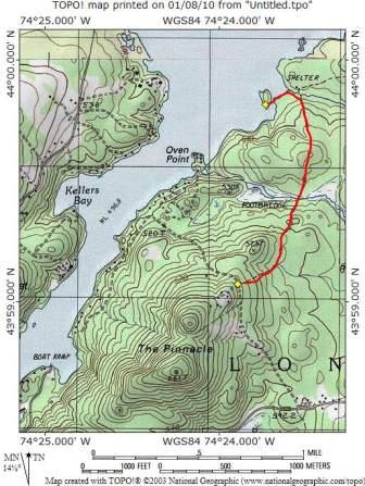
Here is a link to the topo map of the trail: TOPO
Map
Weather in
Long Lake, NY
NOAA Weather Forecast
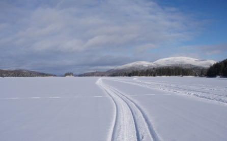
Trailhead parking is on Tarbell Rd at N 43 59.063, W 074 23.866.
Parking for sled trailers or skiers who choose to run the lake is
at the Public Boat Launch - N43 58.710 W074 24.973 Remember, travel
on ice is at your own risk. Check conditions with the locals.
Snowmobiles not allowed on shore or foot trail. It is a wilderness
area.
WARNING! Travel on ice can be dangerous! Check ice conditions
before going out. Check with the locals. Ice travel is at your own
risk. Two known danger spots are anywhere near the highway bridge
in town, and the spillway. Other areas to watch are near stream
inlets, and shallows near shore. I do not know the local
conditions. I am not a local, although I resemble one. Pedestrians
on the lake at night should have lights on, so snowmobiles can see
you.
If you do not own the gear you need, you can rent it from an
outfitter. Contact GPS Guy for details. You should reserve ahead of
time, and examine the gear before leaving the store to be certain
you are getting the right size, rating, etc. A tall guy does not
fit well into a women's sleeping bag, even when alone. Believe me,
I know.