*********************************************************************************
Warnemünde - Der breiteste Strand an der deutschen Ostseeküste
*********************************************************************************
Das Ostseebad Warnemünde ist ein Ortsteil der Hansestadt Rostock im Norden der Stadt. Die Warnow mündet hier in die Ostsee und gab dem Ort seinen Namen.
Mit einem bis zu 250 Meter breiten Sandstrand verfügt Warnemünde über den breitesten Sandstrand der deutschen Ostseeküste. Der Strand ist durch eiszeitliche Küstenausgleichsprozesse entstanden und verändert sich ständig durch die Anlandungsprozesse (Brandung). Die Entstehungszeit wird auf den Pleistozän und die Kaltzeit datiert. Während der letzten Eiszeit, war Skandinavien und die komplette Ostsee von einer Eisschicht bedeckt. Im Gegensatz zur Kliff- & Steilküste gibt es eine sehr flache Uferzone und ein geringeres Aufkommen an größeren Steinen bzw. Findlingen.
Die Gezeiten. Selbstverständlich gibt es, entgegen vieler Meinungen, in der Ostsee auch Gezeiten. Allerdings gibt es nur eine kleine Meerenge, die die Ostsee mit der Nordsee verbindet, wodurch der Gezeitenschub stark abgeschwächt wird. Die Differenz zwischen Gezeiten liegt lediglich bei ca. 10cm und ist somit kaum spürbar.
Diese Küstenform wird als Flachküste bezeichnet. Die Flachküste besteht aus:
- verschiedenen Sandriffen und den dazwischen liegenden Sandrifftälern,
- dem Sommer- und Winterstrandwall
- und den Dünen, mit denen der Strand abschließt.
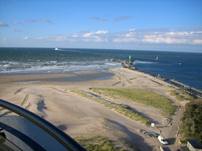
Die Wellen brechen meist bei einer mittleren Wassertiefe, wobei die Wellenhöhe dort meist der Wassertiefe entspricht. Der Strand an der Westmole von Warnemünde bietet feinen weißen Strandsand, der westlich nach 3,7 km am Hochufer des Ausflugsortes Wilhelmshöhe, mit Kieselsteinen durchsetzt, endet. Weiterhin seht Ihr in westlicher Richtung in ca. 4,7 km Entfernung die Steil- & Kliffküste mit dem Kap „Stoltera“.
Die Geprägt wird der Strand insbesondere von der imposanten Westmole. Von den Koordinaten aus gesehen, seht Ihr sie in Nord-Östlicher Richtung. Die Westmole steht komplett auf einem Fundament aus eiszeitlichen Findlingen, die aus der Fahrrinne geborgen wurden. Auf der Westmole könnt ihr viele Findlinge mit wunderschönen Versteinerungen entdecken.
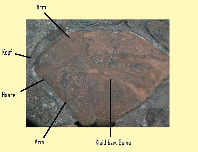
Um eine dieser Versteinerungen ragt sich eine alte Warnemünder Geschichte, die "Blaumantelsch". Hier handelt es sich um ein „gefallenes“ Warnemünder Mädchen, das zur Zeit Napoleons gefallen an einem französischen Soldaten fand. Was dabei rauskam kann sich mancher denken: Das Mädchen wurde schwanger und der Soldat verließ mit seinem Kameraden die Stadt und folgte seinem fliehenden Kaiser. Die Warnemünder kleideten das schwangere Mädchen in einen blauen Mantel, was so viel wie eine öffentliche Büße bedeutete. Die Warnemünder machten ihr durch viele Beschimpfungen das Leben schwer, da sie Schande über sich und den Ort gebracht hätte. So stürzte sie sich an der Westmole in die Ostsee.
*********************************************************************************
Zum Cache!
*********************************************************************************
Es gibt verschiedene Arten von Stränden. Steil abfallende – z.B: an den Steilküsten westlich von hier - und wie hier in Warnemünde langsam abfallenden Strand, beginnend an den Dünen – abfallende bis zur Wasserlinie.
- Berechne den Höhenunterschied zwischen der Düne/Promenade zur Wasserkante.
Die unterschiedliche Länge der Strände hängt mit der anlandenden Strömung zusammen, durch die Sand angespült wird und sich beispielsweise auch Sandbänke bilden. Durch den Einfluss der Wasserströmung wird entweder Sand und Gestein angespült, oder vom Land abgetragen.
- An der Wasserkante kannst du anhand der Sedimente genau erkennen worum es sich hier handelt. Wird hier Sediment angelandet oder abgetragen?
Aber wie breit ist der Strand denn nun? Dies ist abhängig von der Strömung und dem Wetter, ob anlandiger Wind oder ablandiger herrscht. Je nach dem variiert die breite des Strandes um bis zu 100 Meter.
- Miss die breite des Standes zwischen Promenade und Wasserkante!
Der Strand besteht aus vielen verschiedenen Sedimenten, die sich über millionen Jahre, seit der Eiszeiten, abgelagert haben. Diese verschiedenen Sedimente bilden die verschiedenen Schichten des Strandes.
- Wenn Du dich jetzt gerade von der Promenade zur Wasserkante begibst, dann sind diese Unterschiede gut sichtbar. Beschreibe was dir in Bezug auf die Breite und Zusammensetzung der Sedimente an der Wasserkante im Gegensatz zum Bereich vor den Dünen auffällt.
Auch an der Ostsee gibt es Gezeiten. Ebbe und Flut sind hier jedoch kaum merklich, denn der Wasserspiegel bewegt sich nur um 10 bis 15 cm, was im Verhältnis zur Nordsee minimal ist. Dies ist aber gut für den Strand, denn so wird er nicht überspült.
- Verantwortlich für die Gezeiten ist? Die Antwort findest du „38cm“ neben der Erde, in etwa bei: N 54°10.860 E012°05.040
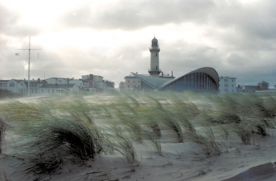
Das berühmte Bild! Dieses ist ja bekanntermaßen keine Logbedingung mehr, also nennen wir es „Owner-Wunsch“. Macht ein Bild von Euch oder eurem GPS, oder Listing-Ausdruck, am Strand mit einem der Leuchttürme im Hintergrund.
Oder Ihr sucht den Stein der „Blaumantesch“. Ihr findet ihn im Bereich zwischen N 54°11,020 E 012°05,215 und N 54°11,060 E 012°05,204. Zur Orientierung stelle ich ein Bild mit ein.
Eure antworten sendet Ihr mir bitte vor eurem Log zu!
Bitte denkt unbedingt daran, eure Mailadresse zu den Antworten mit hinzu zufügen!
*********************************************************************************
Und nun viel Spaß und Happy Hunting!
*********************************************************************************
Translated with google
*********************************************************************************
Warnemünde - The widest beach on the German Baltic coast
*********************************************************************************
Warnemünde is a part of the Hanseatic city of Rostock in the north of the city. The Warnow flows into the Baltic Sea, and gave the place its name.
With up to 250 meters wide, sandy beach Warnemünde has the widest beach of the German Baltic coast. The beach is formed by glacial processes and compensation coast is always changing by the surf. The time of origin is dated to the Pleistocene and glacial. During the last ice age, Scandinavia and the entire Baltic Sea was covered by a layer of ice. In contrast to the cliff-cliffs and there is a very shallow shore zone and a lower volume of large stones or boulders.
The tides. Of course there are, contrary to many opinions, in the Baltic Sea and tides. However, there is only a narrow strait, which connects the Baltic Sea with the North Sea, making the tidal shear is weakened considerably. The difference between tides is only at about 10cm and is hardly noticeable.
This coast is known as form have flat. The have flat consists of:
- Various sand reefs and the intermediate sand-riffs,
- The summer and winter beach Wall,
- And the dunes, which closes the beach.
The waves are usually at a mean water depth, the wave height usually corresponds to where the water depth. The beach at the western pier in Warnemünde offers fine white sand beach to the west for 3.7 kilometers along the banks of the trip ends Wilhelmshöhe place, interspersed with pebbles. Furthermore, you can see in a western direction to about 4.7 km from the steep cliff and coast to the Cape "Stoltera.
The beach will be characterized in particular by imposing the western pier. Viewed from the coordinates, you see them in north-eastern direction. The western pier is complete on a foundation of glacial boulders that have been recovered from the fairway. On the western pier many boulders you can discover beautiful fossils.
To one of these fossils is an old projects Warnemünder history, "Blaumantelsch. This is a "fallen" Warnemünder girl who was in love at the time of Napoleon to a French soldier. What came out here can think of many: The girl became pregnant and left the soldier and his comrades followed his fleeing King and leave the city. The Warnemünder the pregnant girl dressed in a blue coat, which meant as much as a public penitents. The Warnemünder made it difficult for many insults life, since she had brought shame on himself and the city. So they rushed to the western pier in the Baltic Sea.

*********************************************************************************
To the Cache!
*********************************************************************************
There are different types of beaches. Steeply sloping - e.g. on the cliffs west of here - and, like here in Warnemünde, slowly sloping beach, starting at the dunes - sloping to the waterline.
1. Calculate the difference in height between the dune / promenade and the waterfront.
The different lengths of the beaches are related to the incoming current, through which sand is washed up and, for example, sandbanks also form. Due to the influence of the water current, either sand and rocks are washed up or removed from the land.
2. At the water's edge you can see exactly what this is about based on the sediments. Is sediment landed or removed here?
But how wide is the beach now? This depends on the current and the weather, whether the wind is onshore or offshore. Depending on this, the width of the beach varies by up to 100 meters.
3. Measure the width of the stand between the promenade and the waterfront!
The beach consists of many different sediments that have been deposited over millions of years since the ice ages. These different sediments make up the different layers of the beach.
4. If you are walking from the promenade to the waterfront, these differences are clearly visible. Describe what you notice in relation to the width and composition of the sediments at the water's edge in contrast to the area in front of the dunes.
There are also tides on the Baltic Sea. The ebb and flow of the tide are hardly noticeable here, however, because the water level only moves 10 to 15 cm, which is minimal in relation to the North Sea. But this is good for the beach because it will not be flooded.
5. Is responsible for the tide? You can find the answer “38cm” next to the earth, roughly at: N 54 ° 10.860 E012 ° 05.040
The famous picture! As is well known, this is no longer a log condition, so we call it “owner request”. Take a picture of you or your GPS, or listing printout, on the beach with one of the lighthouses in the background.
Or you are looking for the stone of the "blue mantesch". You can find it in the area between N 54 ° 11.020 E 012 ° 05.215 and N 54 ° 11.060 E 012 ° 05.204. I put a picture in for orientation.
Please send your answers to me in front of your log!
Please think is important to remember your email address to the answers to add add!
*********************************************************************************
Have Fun and Happy Hunting!
*********************************************************************************
Translated with google
*********************************************************************************