Trojaczki / Triplets

 [PL]
[PL]
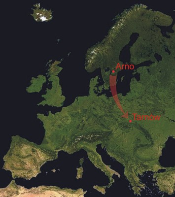
W roku 2001 w Tarnowie podczas prac ziemnych na prywatnej posesji odkryto 3 granitoidowe skały przyniesione przez lodowiec w epoce Plejstocenu zwane głazami narzutowymi lub eratykami. W Tarnowie można licznie spotkać granitowe głazy narzutowe odnajdywane w ziemi na przestrzeni wieków, które zostały wmurowane w ściany kamienic, lub zostały użyte jako pomniki, jednak rozmiar jednego z odnalezionych w 2001 r. głazów jest imponujący. Ma on ponad 10 m obwodu, 2 m wysokości i waży ok 28 ton. Jest to jeden z największych głazów narzutowych jaki do tej pory znaleziono w południowej Polsce. Pierwotnie był jeszcze większy, gdyż dwa mniejsze głazy są odłupanymi fragmentami większej bryły. Ustalono, iż pochodzi on z masywu Arnö w środkowej Szwecji położonego ok. 40 km na zachód od Sztokholmu (Fig. 1). Głaz przebył więc drogę ponad 1000 km. Ze względu na unikatowe walory tego obiektu został on przewieziony wraz ze swoimi mniejszymi "braćmi" w obecne miejsce i ustanowiony pomnikiem przyrody pod nazwą "Trojaczki".
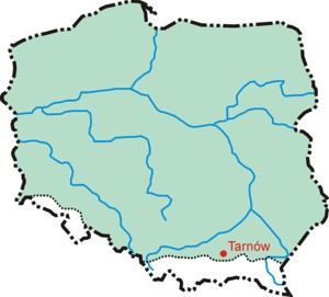
Niniejsze głazy narzutowe są pozostałością po zlodowaceniu południowopolskim, które objęło swym zasięgiem niemal całą Polskę (Fig. 2). Miało to miejsce w plejstocenie, 730-430 tys. lat temu. Wówczas lodowiec doszedł do progu Karpat wchodząc dolinami do wysokości 400 m n.p.m. Zatopione w masie lodowej głazy przemieszczały się wraz z lodowcem. W czasie topnienia lodowca materiał skalny wleczony przez niego pozostawał na miejscu. Większość tego materiału to drobniejsza frakcja będąca mieszanką gliny, piasku, żwiru i kamieni (tzw. glina zwałowa). Jedynie najodporniejsze skały, takie jak granitoidy, mogły przebyć tak dużą odległość zachowując swoje pokaźne rozmiary. Na podstawie miejsc znalezienia głazów polodowcowych można wyznaczyć granice zlodowacenia, oraz określić kierunek przemieszczania się masy lodowej.

 [EN]
[EN]
In 2001 in Tarnów, during groundwork on a private land, three unusual granitoid rocks were discovered. The rocks are glacial erratics which means that they were transported there by a glacier (in this case in Peistocene times). In Tarnów you can spot many glacial erratics: they were found in the ground and then were embeded into the walls of houses or used as memorials. However, the size of one erratic found in 2001 is truly impressive. It is over 10 metres in circumference, 2 meters high and it weighs about 28 tons. It’s one of the biggest erratics ever found in Southern Poland. Originally, it was even larger - the two other smaller rocks nearby are splinters from the original boulder. Scientists found out that the boulder originates form Arnö massif in Central Sweden, about 40 km west from Stockholm (see Fig 1). Thus, the erratic has travelled over 1000 km. Due to its unique value, the boulder was moved with its smaller "brothers" to the present spot and established as a natural memorial named “Trojaczki” (Triplets).
These erratics are the remnants after the Mindel Stage of glaciation (during Pleistocene, 730-430 thousands years ago) which covered almost the whole territory of Poland (see Fig 2). At that time the glacier reached the doorstep of the Carpathians entering into valleys up to 400 m a.s.l. Set in the ice, erratics moved together with a glacier. During the peridos of melting a load of rocks carried by the glacier would be dropped and left behind (or rather left at the front while the glacier shrank and retreated). The sediment was mostly of finer fraction – mixture of clay, sand and gravel with some boulders only. Such sediments (which are poorly sorted and often have many angular pieces of rocks) are called glacial till. Only the hardest rocks, like granitoids, can be transported a long way keeping their huge size. If you identify locations where erratics are found and plot them on a map, you can delimit glaciation and determine the directions of glacier movement.
Earthcache
 [PL]
[PL]
Aby zaliczyć znalezienie tej skrytki musisz odwiedzić to miejsce, odpowiedzieć poprawnie na poniższe pytania i przesłać je do mnie za pomocą formularza kontaktowego. Odpowiedzi możesz nadesłać w języku polskim, słowackim, czeskim lub angielskim.
1. Przy głazach znajduje się tablica informacyjna - odczytaj z niej wiek tych skał w miliardach lat.
2. Na tej samej tablicy znajduje się informacja o epoce geologicznej - jak brzmi jej nazwa oraz jaki był zakres jej trwania?
3. Określ w centymetrach grubość jasnej żyły znajdującej się w głazie o średniej wielkości.
4. Dodatkowo zamieść w logu swoje zdjęcie z GPSem w reku na tle największego z głazów (opcjonalnie).
PARKING
W pobliżu głazów znajduje się dogodny, darmowy parking.
Podziękowania dla xenotime za pomoc!
 [EN]
[EN]
To log your find, you have to visit this spot, answer to the questions below and send it to me via contact form. Please, send your answers in English, Czech, Slovak or in Polish language only.
1. Near the boulders there is an information plaque – read what is the age of these rocks in mega years (British milliards of years, American billions of years).
2. There is also information about a geologic epoch – what is the name of the epoch and its timing (give the range)?
3. Determine (in centimeters) the thickness of the bright-coloured vein in the middle-sized erratic.
4. Additionally, attach to the log a picture of yourself holding a GPSr with the biggest erratic in the background (optional).
PARKING
Close to the erratics there is a handy free car park.
Thanks to xenotime for help!
