SSB - Kiptopeke State Park Traditional Geocache
SSB - Kiptopeke State Park
-
Difficulty:
-

-
Terrain:
-

Size:  (regular)
Related Web Page
Please note Use of geocaching.com services is subject to the terms and conditions
in our disclaimer.
During the first challenge along the Star-Spangled Banner GeoTrail, over 400 first edition SSB geocoins were awarded. We would like to thank everyone who participated in the Star-Spangled Banner GeoTour. We are currently out of geocoins but stay tuned for other opportunities along the Star-Spangled Banner GeoTour!
Come on a journey to remember and commemorate the dramatic chain of events, people and places that led to the birth of our National Anthem.
The story of the Star-Spangled Banner was shaped by the events of the Chesapeake Campaign during the War of 1812. From February 1813 until February 1815, the Chesapeake Bay was the center of a fierce struggle between the British and Americans. Places and landscapes still exist today that provide a touchstone to the past. The trail traces events and related sites that figured prominently in the Chesapeake Campaign of the War of 1812 that have national significance, physical integrity, and the potential for contemporary recreation and interpretation.

You are seeking a traditional hide off of the Songbird Trail. You can hike or bike to this cache with an estimated roundtrip of 2.6 miles. Parking fees are $3 Monday - Friday and $4 Saturday, Sunday and major holidays. Kiptopeke is a wonderful park that offers a wide variety of activities including hiking, biking, camping, fishing, boating, swimming, and birding. The park does offer cabin and yurt rentals. Please click here to view the parks website.
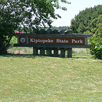
Located at the tip of the Delmarva peninsula, Kiptopeke State Park is situated at the mouth of Chesapeake Bay, where the nation’s largest estuary meets the Atlantic Ocean and where the British officially set up a blockade on December 26, 1812. This effectively cut off both incoming and outgoing trade, significantly damaging the economy of the region. Historians have documented hundreds of encounters between merchant vessels and the British, the majority of which suffered capture. A lucky few were able to make it to safety, often as a result of local knowledge of the sea and shoreline.
A small number of ships did manage to elude the blockade. This included American Navy vessels as well as privateers. In contrast to pirates, the privateers of 1812 were officially licensed by the government through a document known as “letters of marque and reprisal.” Crewed by civilians on privately owned vessels, the privateers targeted Britain’s merchant fleet. With Baltimore as its center, the privateer fleet across the Bay numbered in the hundreds - a significant addition to the modest size of the American Navy. Indeed, over the course of the conflict, it is estimated that privateers may have captured over 2,000 British ships!
Privateers were active at the mouth of the Bay near Kiptopeke and well beyond, capturing vessels even before the blockade was officially declared. The publication, Encounters with the British in Virginia during the War of 1812, documents many of these episodes. For example, in September 1812, the privateer Liberty seized the Nancy, an American ship with a British license to trade, and sent her to Baltimore as a prize. Soon after, in January 1813, another privateer, Dolphin, captured the John Hamilton off the Virginia Capes. After also being sent onto Baltimore, her cargo of mahogany was used to build the frigate USS Java. It is also interesting to note that Joshua Barney, the man behind the Chesapeake Flotilla, was himself a privateer during both the War of 1812 and the American Revolution.
North of Kiptopeke (Northampton County) in neighboring Accomac County, the British attempted more vigorous landings and raids. After capturing Tangier Island, they attempted to land at Pungoteaque Creek in May 1814, using a force that included African American men who had escaped from slavery and joined the British. A band of Virginia militia repelled this attack, with the British ultimately returning to their ships. Later, in June, more British troops (approximately 500) would land in the county, this time overwhelming the local militia.
Today, the views from Kiptopeke State Park's shoreline are far more peaceful, dominated by wildlife-watching. Migrating birds congregate at this point on the Delmarva peninsula before moving on to breeding or wintering grounds. Coastal Virginia Wildlife Observatory volunteers capture, examine, weigh, band and release resident and migratory birds in September and October of each year. Hawks, kestrels, osprey and other birds of prey are observed and banded from September through November. Kiptopeke's hawk observatory is among the top 15 nationwide. Along with bird-watching, the park also offers guided hikes, fishing clinics, canoe programs, beach bonfire programs, waterfront activities, hayrides, and weekly birding programs in the fall.

Thanks to Sam Sweeney, Park Manager for helping with this hide and to the Maryland Geocaching Society for assisting with this project!
Additional Hints
(No hints available.)