During the first challenge along the Star-Spangled Banner GeoTrail, over 400 first edition SSB geocoins were awarded. We would like to thank everyone who participated in the Star-Spangled Banner GeoTour. We are currently out of geocoins but stay tuned for other opportunities along the Star-Spangled Banner GeoTour! A new challenge with a new prize will be ready in 2015.

Come on a journey to remember and commemorate the dramatic chain of events, people and places that led to the birth of our National Anthem.
The story of the Star-Spangled Banner was shaped by the events of the Chesapeake Campaign during the War of 1812. From February 1813 until February 1815, the Chesapeake Bay was the center of a fierce struggle between the British and Americans. Places and landscapes still exist today that provide a touchstone to the past. The trail traces events and related sites that figured prominently in the Chesapeake Campaign of the War of 1812 that have national significance, physical integrity, and the potential for contemporary recreation and interpretation.
The Star-Spangled Banner (SSB) Geotrail launched February 27, 2010 with over 30 caches within Maryland, Virginia and the District of Columbia. A trackable geo coin will be awarded to the first 400 geocachers, while supplies last, for locating at least 20 SSB caches. To be eligible for the coin, geocachers must download a passport from either the SSB Geotrail or Maryland Geocaching Society website. Geocachers must find and log at least 20 SSB finds, record the code word from each cache on their passport and post a picture of themselve at each cache location. After discovering the 20 required caches, geocachers may have their passports validated in person or via mail at the Friends of Chesapeake Gateways office located at 410 Severn Ave, Suite 314, Annapolis, MD 21403. Please refer to the passport for complete validation instructions.
Participating in the SSB geotrail is fun and we hope that many people join in. However, it is not a requirement for logging your find on this cache once you find the container.
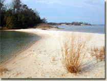
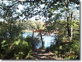
Myrtle Point Park is a forested peninsula, bounded by the Patuxent River, Mill Creek and Sam Abel Cove in St. Mary’s County, Maryland. In 1814, it would have been a prime location to observe the movements of the Chesapeake Flotilla, a fleet of gunboats, built from 1813-1814, under the supervision of Commodore Joshua Barney. A revolutionary war hero, Barney hoped his hastily constructed fleet might serve to blunt the sharp edge of British aggression in Chesapeake Bay and its waterside communities.
The first skirmish between British forces and the Flotilla occurred at Cedar Point at the mouth of the Patuxent River, just south of the Myrtle Point Peninsula. On June 1, 1814, following a night spent anchored at nearby Drum Point, Barney encountered a British squadron led by Captain Robert Barrie. Surprised by the size of their adversary, the British retreated, hoping to rendezvous with a 74 gun ship-of-the-line, the H.M.S. Dragon, anchored south at the mouth of the Potomac. Barney gave chase, but was waylaid by a sudden squall and then found himself up against the larger vessel. An exchange of fire followed, ultimately ending in a stalemate. In the end, Barney had to retreat back up the Patuxent River, into St. Leonard Creek. The British did not follow, instead choosing to blockade the River’s mouth, giving them time to re-group and better consider how to defeat the Flotilla.
Though the Battle had no definitive victor, Cedar Point demonstrated to the British that Barney had succeeded in assembling a credible threat to their naval dominance on the Chesapeake. In addition, during the Battle a deployment of men recently escaped from slavery and trained on Tangier Island took part in the hostilities on the side of the British marking one of the first times the group had engaged with American forces. Following the engagement, the men drew high praise from the British for their efforts, as reported by historian Donald Shomette is his work, Flotilla: The Patuxent Naval Campaign of the War of 1812.
Today, Myrtle Point Park is heavily forested, with mature trees lining the beaches ringing the perimeter. It is home to a great variety of wildlife, from river otters, mink, and cottontail rabbits to diamond-backed terrapins, green frogs, and salamanders. There are hawks, herons, owls, warblers, and eagles. The Park also contains many significant archeological sites, both colonial and American Indian.
You are seeking a traditional hide. Myrtle Point is open sunrise to sunset (except for special evening and night activities). During the winter months, gates are closed but the park is open for use by pedestrian access. During this time, the public is welcome to park at the entrance and walk into the park. Park is scheduled to re-open on April 1, 2009. There is no fee to use this park.

Thanks to Terri & Billy for helping with this hide and to the Maryland Geocaching Society for assisting with this project!