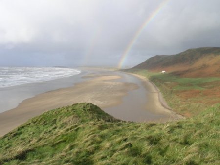
Rhossili Bay is the largest and one of the most distinctive and striking bays on the Gower peninsula. At nearly 3 miles in length it is by far the longest beach on Gower. Its distinctive shape is caused by the fact that the two arms of the bay comprise of relatively hard limestone while the middle area is Old Red Sandstone which erodes more quickly forming the gentle sweep of the bay as seen today.
Behind the bay is Rhossili Down which rises to nearly 200m in height. This, combined with the bay’s shape makes it an ideal location for thermals and you’ll often see paragliders and hang gliders flying from the top of the Down eventually landing on the beach below. Notice how level the down is on top – this is because it used to be a beach level that has since risen to this height above ground. The lower level of land (with the distinctive Old Rectory built on it) was caused when land slumped from above during more recent ice age eras and is known as a solifluction terrace.
As you walk towards the distinctive string of islands at the southern tip of the bay called Worms Head, notice again how flat the land appears to be and indeed how level the majority of the island chain is. Again, like Rhossili Down, millions of years ago, this was once a beach at sea level but the land has raised over the subsequent millennia.
If you were looking up at the cliffs from the beach below, you’d notice a series of “caves” filled with red clay. The clay dates back to the tertiary era (between 65 million to 2 million years ago) when this area was a desert. The caves themselves are much older.
Again, down at the beach level, you may see the last vestige remains of a small quay that was once used to load limestone that was quarried from these cliffs onto boats that would then head out to Somerset and Devon to be heated and turned into lime.
On the headland overlooking Worms Head, notice the dry stone walls enclosing long strip-like fields. Called the Vile (after viel meaning field), this is one of the last Mediaeval strip field systems left in the United Kingdom.
The islands name is derived from the Norse word ‘wurm’ for dragon. It’s easy to imagine how early sea farers saw the islands resemblance to a dragon swimming in the water.
At the tip of the peninsula, just before the land drops down onto the causeway between the mainland and the islands, you’ll come across the coastguard lookout. This was built in Victorian times to monitor shipping along this hazardous coastline, but more recently monitors walker activity on the causeway also known as the “Shipway”. The tides close the causeway twice a day and in a matter of seconds rapidly turn it into an extremely hazardous stretch of water. Many people end up being stranded on the island each year so check the tide times before you venture across–– people have died trying to wade/swim across.
If you look carefully, near the end of the headland you can find a 2 metre long ship’s anchor, now embedded into the surrounding sand, indicating that this causeway is not just dangerous to walkers today – it sank more than one ship in the past too. This anchor belongs to The Samuel, which sank in 1884.
Tasks:
Before answering the questions below, log your find, including (optionally) a photograph of yourself with your GPSr in view (if possible) with either Worms Head or Rhossili Bay as a background. If you can manage a picture of yourself in front of the anchor with your GPRr in view, I'd be most impressed!!!
Then, please email me your answers to the following questions via my Geocaching profile:
* Explain why the causeway has eroded like this but the headland and islands remain.
* What is the scientific term for the caves filled with red clay, described above?
* On the path down to the causeway, before it was re-surfaced with a more durable material, you may have found numerous bits of coal. Coal doesn’t belong in the geology of this immediate area – can you suggest how these lumps got there? (hint: the answer has little to do with the area’s geology!)
Please also click on the "I want to send my email address along with this message" if you're submitting through Geocaching.com and it's not on by default - it makes it so much easier for me to respond!
Logs that haven't sent me the answers to the questions will be deleted as will if there's lack of evidence you've actually been to the location.
When planning your visit, the National Coastwatch Institution's website has useful emergency and site details.
