The original Dutch name for these buttresses and kloofs was de Gevelbergen (Gable Mountains) which reminded them of the narrow Dutch houses and gables of home. It is assumed the name was changed during one of the British occupations.
There are more than twelve peaks and only the last one overlooking Hout Bay, Judas Peak carries an apostles name. The Pipe Track which was built in 1887 to service the water pipes from the reservoirs on top of Table Mountain ends officially in Slangolie Ravine where the original tunnel carrying the water ended, there are still some old pipes and steps up the side of the ravine which is a very dangerous and scree filled gorge. The new tunnel built in 1964 carrying the water from the top of the mountain now comes out on Wood Buttress and can be seen if you approach this cache from along the Pipe Track either from the top of Theresa Avenue in Camps Bay or from Kloof Nek.
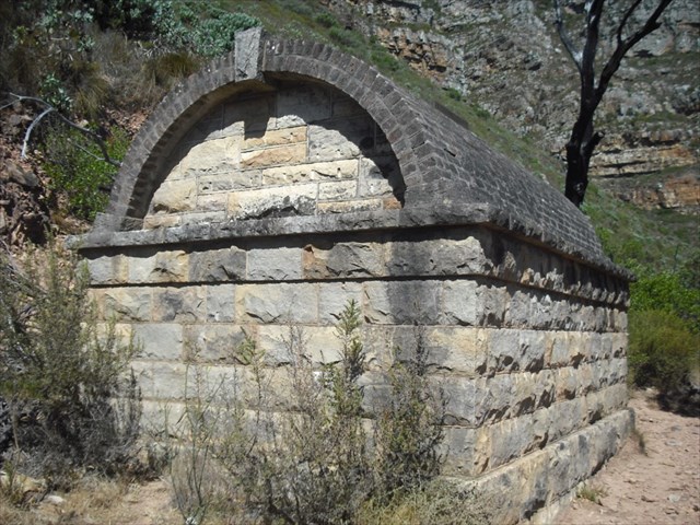
There is an impressive break pressure chamber along the track of very fine stonework with a vaulted brick roof on the way as well.
After you have crossed the Slangolie Stream and have climbed the path out the other side there is a good spot for a break for tea or water in the overhang with a good view over the path you have just come along and the steps etc across the valley. Pity about the graffiti – amazing that folk actually take paint to leave their marks when walking on the berg?
I placed this cache after doing the impressive Oudekraal April Fool cache on a windy, but warm day on the mountain. We were walking back along the track from the Corridor/ Oudekraal Path junction and as we came around a corner I saw “The View” which includes Table Mountain, Signal Hill, Lion’s Head and Robben Island and felt this was an ideal spot to put another cache.
The cache is just up from the path and no fynbos was destroyed in the placing and none needs to be destroyed in its retrieval, there are enough rocks and a bit of a path to go up to retrieve the cache which is under a rock which is parallel to the view.