 Mühlsteinbruch Hinterhör
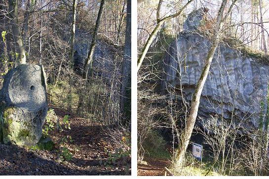
Vom 16. bis ins 19. Jahrhundert wurden bei Hinterhör Sandsteine des Helvetikums per Hand als Mühlsteine abgebaut. Sie fanden im weiten Umkreis als Unter- bzw. Bodensteine in den Mühlen Verwendung.
Noch heute ist der Steinbruch mit seinen charakteristischen Abbauspuren ein eindrucksvolles Denkmal der Wirtschafts- und Technikgeschichte im Raum Neubeuren.
Die Helvetikum-Zone
Im Zuge der Alpenentstehung kam es in der Kreide- und Tertiärzeit in Folge des Zusammenstosses der europäischen und der adriatischen Platte zu einer starken Einengung der Gesteinsschichten. Dabei zerbrachen Gesteinspakete und wurden als tektonische "Decken" großräumig übereinandergeschoben. In Oberbayern bilden die tektonischen Decken der kalkalpinen Zone die morphologisch auffallenden Bayerischen Hochalpen. An ihrem Nordrand werden sie von landschaftlich oft nicht sehr deutlich in Erscheinung tretenden weiteren tektonischen Baueinheiten, der Flysch- und der Helvetikum-Zone begleitet. Die Ablagerungen bei Neubeuren gehören zur Helvetikum-Zone, die in Oberbayern nur in einem sehr schmalen Streifen vorkommt.
Ihren Namen erhielt sie aus den Schweizer Alpen, da diese tektonische Einheit nach Westen im Allgäu und Vorarlberg immer breiter und höher wird und schließlich in der Schweiz ("Helvetia") ein großes Gebiet einnimmt.
Als Hauptgesteine des Helvetikums findet man Kalk- und Mergelsteine, die von Sand- und Siltsteinen unterbrochen sind. Die Serie ist am Südrand des europäischen Kontinents in einem flachen Schelfmeer entstanden. Bei Neubeuren aufgeschlossene Gesteine wurden in der obersten Kreide und im Alttertiär abgelagert.
Mühlsandstein von Hinterhör
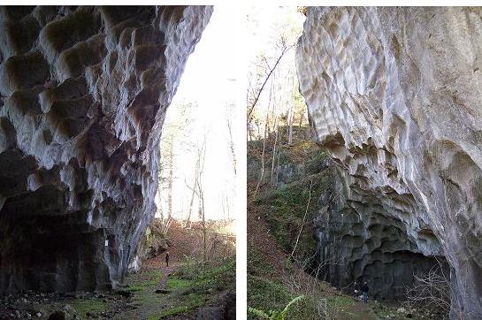
Ein unübersichtlicher Schuppenbau und eine sich auf engem Raum rasch ändernde Gesteinsausbildung lassen eine Rekonstruktion der genauen Ablagerungsverhältnisse des Helvetikums bei Neubeuren nur schwer zu. Als Ablagerungsbereich vermutet man ein von Inseln durchsetztes Flachmeer. In dieses mündeten vom Festland Flüsse, die bereichsweise Sandfächer bildeten, während daneben gleichzeitig Kalksteine entstanden. Ein Beispiel für eine derartige lokale Sandschüttung stellt der Mühlsandstein dar, der hier im Steinbruch Hinterhör drei Jahrhunderte lang abgebaut wurde. Nur bei Hinterhör erreicht er eine Mächtigkeit von 28 Metern, bereits im Steinbruch von Altenbeuren weist er nur noch acht Meter Mächtigkeit auf, in anderen Aufschlüssen ist er vollständig durch kalkreichere Gesteine ersetzt.
Der Mühlsandstein ist ein grauer mittel- bis grobkörniger Sandstein aus gut gerundeten Quarz- und Feldspatkörnern, die mit kalkigem Bindemittel verkittet sind. Im frischen Zustand erwies sich der Stein als überaus zäh und hart und war daher als Mühlstein sehr begehrt. Da die Sandsteinschicht im Bruch steil nach Süden einfällt, bildet sie einen Überhang, der durch den Abbaubetrieb noch weiter ausgehöhlt wurde.
Abbau der Mühlsteine
Der Steinbruch Hinterhör wurde 1572 "aufgeschlagen", bis 1860 wurden dort Mühlsteine gewonnen. Mathias Flurl schilderte 1792 in seiner "Beschreibung der Gebirge von Baiern und der Oberen Pfalz" die spezielle Technik, derer sich die Arbeiter beim Abbau der Mühlsteine von Hand bedienten:
"Die Gewinnung derselben ist für die dasigen Arbeiter sehr mühsam und gefährlich, und wenn ihnen nicht ein sehr einfaches Mittel bey Sprengung dieser Steine herrliche Dienste leistete, so wären sie kaum im Stande, die Stücke groß genug vom Platze zu bringen. Wenn sie nämlich mit dem Eisen einen hinlänglich tiefen Schram in das Gebirg gebrochen haben, so treiben sie hölzerne Keile indenselben, und beschütten sie solange mit Wasser, bis das aufgeschwollene Holz den Felsen unter einen fürchterlichen Krachen von einander sprengt." Vor dem Abtransport wurde der Stein noch behauen und mit dem Achsloch versehen. Danach folgte der äußerst mühsame Transport der schweren Steine zum Inn, wo sie auf Plätten verladen wurden. Die nahe Lage zum Fluss, auf dem die Steine verschifft und damit gehandelt werden konnten, ermöglichte dem Mühlsteinbruch Hinterhör ein fast 300jähriges Bestehen.
Die Bearbeitungsspuren der Rundlinge sind heute noch deutlich an der Wand des Mühlsteinbruch zu erkennen und so präsentiert sich der aufgelassenen Steinbruch als eindrucksvolles Denkmal der ehemaligen Mühlsteingewinnung.
Quelle: (c) Bayerisches Landesamt für Umwelt
Um diesen Cache loggen zu dürfen, beantworte mir bitte folgende Fragen:
1. Begib Dich zunächst zur offiziellen Geotop Schautafel bei N47 46.694 E012 09.390 (Headerkoordinaten). Mache ein aktuelles Bild von Dir und Deinem GPSR und lade es mit Deinem Log hoch. (optional, aber der einzig wirkliche Beweis, dass Du da warst)
2. Wenn Du von der Tafel zur Abbauwand schaust siehst Du deutlich die Löcher, aus denen die Steine entnommen wurden. Wie viele dieser Stellen siehst Du in in einer horizontalen Ebene nebeneinander? (Also ganz links anfangen und dann zählen, bis man rechts angekommen ist)
3. In der Felswand hängt eine weiße Tafel. Darunter sieht man deutlich das kreisrunde Anfangsstadium eines noch nicht vollständig herausgeschlagenen Mühlsteines. Welchen Durchmesser hat er?
4. In einem fertigen Mühlstein befindet sich in der Mitte immer ein Loch. Wie groß war es typischerweise bei den hier abgebauten Steinen? (Evtl. findet sich ja ein Stein, bei dem man das messen könnte)
5. Maile mir die Antworten zu den Fragen 2 bis 4. (und damit meine ich nicht: Schicke mir eine Nachricht im Message Center!) Du darfst sofort nachdem Du die Mail geschickt hast loggen. Sollte etwas nicht stimmen, melde ich mich.
Bitte bedenkt, jeder ist selbst für sein Leben und seine Sicherheit verantwortlich. Wer herumklettert und runter fällt ist selbst schuld.
Beeindrucktes Staunen wünscht, Andreas
 Millstone Quarry Hinterhoer
From the 16th till the 19th century sandstones of the Helvetism were diminished by hand as Millstones at Hinterhoer. They were used in the mills in the wide vicinity as under- or groundstones. Today the stone quarry with its typical dismantling tracks still is an impressive monument of the economic history and history of technology in the area of Neubeuren.
The Helvetism zone
During the Alpine origin in the chalk and tertiary as a result of the collision of the European and the Adriatic plate it came to a strong constriction of the rock layers. Besides, rock packages broke and became tectonic "covers" extensively pushed about one other. In upper Bavaria the tectonic covers of the lime-alpine zone form the morphologically striking Bavarian high-level alps. In their north edge they become of the regional often not very clearly appearing other tectonic construction units which accompanies Flysch-and the Helvetism zone. The depositions with Neubeuren belong to the Helvetism zone which seems in Upper Bavaria only in a very narrow stripe.
They received their name from the Swiss Alps, because this tectonic unity becomes broader and broader and higher to the west in the Allgau and Vorarlberg and takes, finally, in Switzerland ("Helvetia") a big area.
As main rocks of the Helvetism you can find lime- and marl-stones which are interrupted by sand and siltstones. The series originated in the south edge of the European continent in a level shelf sea. With Neubeuren open rocks deposited in the uppermost chalk and in the oldtertiary age.
Millsandstone of Hinterhoer
A blind scale construction and a rock formation quickly changing on narrow space hardly allow a reconstruction of the exact deposition relations of the Helvetism at Neubeuren. As a deposition area one supposes a shallow sea flooded with islands. Into this rivers flowed from the mainland which formed area-wise sandy fields, while besides at the same time limestones originated. An example of a so local sand embankment is the Millsandstone which was quarried here in the stone quarry Hinterhoer during three centuries. Only at Hinterhoer it reaches a thickness of 28 metres, where in the stone quarry of Altenbeuren it only shows eight metres of thickness, in other outcrops it is substituted completely with rocks richer in lime. The Millsandstone is a grey medium to coarse grained sandstone from well circular quartz and feldspar punches which are cemented with calcareous binding agent. In the fresh state the stone turned out exceedingly tough and hard and was desired, hence, as a millstone very much. Because the sandstone layer occurs in the break precipitously after the south, it forms a surplus which was hollowed out by the working area even further.
Extraction of the Millstones
The stone quarry Hinterhoer was "whipped" in 1572, till 1860 Millstones were won there. Mathias Flurl described in 1792 in his "description of the mountains of Bavaria and the upper Palatinate" the special technology which the workers helped themselves with the dismantling of the Millstones of hand:
"The production of the same is very laborious for the local workers and is dangerous, and if very easy means by spraying of these stones did not provide them marvellous services, they would hardly be in the state to bring the pieces largely enough from the place. After they have broken an adequately deep notch in the mountains with the iron, they drove wooden wedges in it, and pour them with water as long, as the swollen wood sprinkles the rock under a terribly crashing noise." Before the evacuation the stone was still hewn and provided with the shafthole. Then the extremely laborious transport of the heavy stones followed to the Inn where they were loaded onto barges. The close situation to the river on which the stones could be shipped and be traded with it allowed a nearly 300 year-old existence to the millstone quarry Hinterhoer.
The treatment tracks of the roundlings are clear to recognise even today on the wall of the millstone quarry and thus the left open stone quarry presents itself as an impressive monument of the former millstone production.
Source: (c) Bavarian Environment Agency
In order to log this cache answer the following questions:
1. First go to the official geotop billboard at N47 46.694 E012 09.390 (headercoordinates) and take an current picture of you and your GPSR. (optional, but the only real proof that you have been there)
2. If you now look to the extraction wall you clearly see the holes from which the stones were taken. How many of these places you see in in one horizontal level side by side?
3. At the cliff face you find a white board. Under it you clearly see the perfectly circular initial stage of a not yet completely knocked out millstone. Which diameter does it have?
4. A finished millstone always has a hole in the middle. What?s the typical diameter at the stones diminished here? (Perhaps you find a stone to measure)
5. Mail me the answers to the questions from 2 to 4. You may log rightaway after the mail is sent. If there is something wrong, I will contact you.
Please beware of falling rocks and unsafe area outside the beaten tracks. I am not responsible for any injuries.
I wish you a nice time at the location, Andreas