Parken könnt Ihr Euer Cachemobil bei den Koordinaten N 48°49.021 E 11°40.918 Den Hinweis zu den Finalkoordinaten findet Ihr bei N XLVIII°XLIX.(0)LXII E XI°XL.CMLXXXV
Und bitte versteckt den Hinweis und den Cache wieder gut und geht bei Eurer Suche nicht über den Innenhof des Kastells, denn er wird landwirtschaftlich genutzt. Sonst liegen der Hinweis und das Final ca.150m Fußweg auseinander, welcher leider nicht Rollstuhl und Kinderwagen freundlich sind da es nur Wiese ist. Zeitaufwand zum Finden des Caches schätzen wir so ungefähr 30 min ein, je nach Tauglichkeit des Cachers.
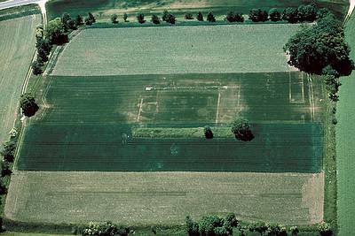
Das ehemalige römische Kastell Pförring (antiker Name Castrum Celeusum) liegt heute rund 900 m nördlich in der Flur vor dem bayerischen Markt Pförring im Landkreis Eichstätt und wurde als Standort einer berittenen römischen Einheit zur Sicherung des Donauüberganges errichtet.
Dieser Übergang findet im Nibelungenlied als „ze Vergen“ Erwähnung.
Der ehemalige Kastellplatz, auch als Biburg bekannt, liegt auf einem fast quadratischen kleinen Plateau am nordöstlichen Rand des Kelsbachtales und hebt sich mit seinen Böschungen deutlich in der Landschaft ab. Angepflanzte Bäume und Büsche deuten zusätzlich die ehemalige Umwehrung an. Neben dem Nordwesttor dieses Lagers, befindet sich heute ein alter baumumstandener Bierkeller. Im Süden liegt die Donauniederung, im Westen fließt der Kelsbach vorbei, der in seinem Namen noch an den antiken Ort erinnert. Der Kastellplatz wird heute noch landwirtschaftlich genutzt. Die ehemals restaurierten Reste des Osttors und des nördlichen Eckturms sind wieder stark zerfallen.
Aufgrund der 1843 auf einem Acker aufgefundenen Bauinschrift ist bekannt, dass die Ala das Kastell im Jahr 141 in Stein ausgebaut hat. Die Reichs-Limes-Kommission konnte feststellen, dass die Wehrmauer aus Kalkstein gut 1 m stark gewesen ist und ein hölzerner Wehrgang im Inneren bestand. Zwischentürme wurden nicht entdeckt. Die Rundbögen der vier Doppeltore hatten die Erbauer aus vulkanischem Tuffstein gehauen. Aus den Überresten der Tore selbst konnte ersehen werden, dass sie aus 16 cm starken eisenbeschlagenen Bohlen bestanden hatten.
Die heute noch bis zu fünf Meter hohe Böschung wurde speziell für die Anlage hergerichtet. Im Südwesten und Südosten des Kastells sind Terrassierungen festgestellt worden, die möglicherweise mit vorbereitenden Planierung der Kastellfläche zu tun haben. Im Südwesten des Areals konnten solche Gründungsmaßnahmen nachgewiesen werden. Sowohl der äußere als auch der innere Graben setzen vor dem Nordosttor aus, während der mittlere nur über eine hölzerne Brücke passiert wurde.
Wie in dieser Zeitstellung üblich, sind die vier Ecken der rund 194 × 201 m (= 3,9 ha) umfassenden rechteckigen steinernen Wehrmauer abgerundet (Spielkartenform). In jeder stand ein Wachturm. Zwischentürme sind unbekannt. Alle vier Tore des Lagers waren mit Doppeldurchfahrten ausgestattet und von je zwei Türmen flankiert.
Das Ende des Lagers wird im Alamannensturm des Jahres 233 gesehen. Ein leider unvollständiger Schatzfund endet mit einer Münze aus der Regierungszeit des Kaisers Severus Alexander (222–235), doch könnte das Ende auch wesentlich später gekommen sein.
Gemeinsam mit dem Kastell entstand um 80 n. Chr. eine Römerstraße, die sich bis heute westlich von Pförring bis Kösching sehr gut verfolgen lässt.
Während der Völkerwanderung wurde Pförring für vereinzelte Bestattungen genutzt, eine Neubesiedlung des Ortes ließ sich daraus jedoch nicht erschließen. Der guterhaltene antike Bestand des Kastells ist auf die erneute Nutzung als Wehrbau im Mittelalter zurückzuführen.
Das Nibelungenlied erwähnt den Donauübergang beim Kastell als „ze Vergen“ (bei den Fährleuten). Danach kommen die Burgunderfürsten Giselher und Gunther, die ihre Schwester Kriemhild auf ihrer Brautfahrt zu König Etzel begleiten, über die Römerstraße am alten Kastellplatz, der während des Mittelalters aufgrund der Weiternutzung noch deutlich sichtbar war, vorbei zum Fluss.
Erstbestückung: Logbuch im Cache belassen
Bleistift im Cache belassen
Stempel im Cache belassen
Anspitzer im Cache belassen
Kleine Tauschgegenstände
Cache ist groß genug um auch Coins und kleinere TB auf zunehmen
So now the tank is back in place and the cache can be searched again.
We also ask you if you've noticed the tank are in the salvage something carefully,
it is not all what it seems.
Lift the lid to use caution.
The former Roman fort Pförring (ancient name Castrum Celeusum) today is about 900 meters north of the corridor outside the Bavarian market Pförring Eichstätt district and was built as the site of a Roman cavalry unit to protect the Danube River crossing.
This transition takes place in the Nibelungenlied as "ze Verge" mention.
The former Castle Square, also known as Biburg, located on a small almost square plateau on the northeast edge of the Kelsbachtales and stands out with its slopes significantly in the landscape. Planted trees and shrubs in addition to interpreting the former town wall. In addition to the northwest gate of the camp, is now an old baumumstandener beer cellar. In the south of the Danube valley is situated in the west of Kelsbach flows by, recalling in his name even to the ancient city. The castle square is still used for farming. The restored remains of the former East Gate and the northern corner tower are strong again disintegrated.
Due in 1843 discovered in a field inscription is known that the ala of the fort in the year 141 has built in stone. The Reichs-Limes-Commission found that the defensive wall of limestone more than 1 m has been strong and there was a wooden walkway on the inside. Zwischentürme were not detected. The arches of the four double-doors of which were the builders carved out of volcanic tuff. From the remnants of Gates himself could be seen that they had existed from 16 cm thick iron beams.
The still up to five-meter-high slope was specially prepared for the facility. In the southwest and southeast of the castle terraces have been identified that may have to do with preliminary grading of the fort area. In the southwest of the site establishing such measures could be identified. Both the outer and the inner moat put out before the Nordosttor, while the average was only happens over a wooden bridge.
As usual at this time position, the four corners of the roughly 194 × 201 m (= 3.9 hectares) overall rounded rectangular stone defensive wall (the form of playing cards). In each stood a watchtower. Zwischentürme are unknown. All four gates of the camp were equipped with double passages and flanked by two towers.
The end of the camp is seen in the storm of the year Alemands 233rd An unfortunately incomplete treasure trove ends with a coin from the reign of Emperor Alexander Severus (222-235), but the end could well have happened much later.
Together with the castle was built around 80 AD, a Roman road, which can be traced to the present west of Pförring Kösching up very well.
While the migration has been used for Pförring isolated burials, a repopulation of the place could be, but it does not open up. The well-preserved ancient stock of the fort is due to re-use as a fortification in the Middle Ages.
The Nibelungenlied mentioned the Danube crossing the fort as "ze Verger" () for the watermen. Then come the Burgundian princes Giselher and Gunther, Kriemhild to her sister on her wedding trip to King Etzel accompany the Roman road at the old Castle Square, during the Middle Ages as a result of continued use was still clearly visible by the River.
You can park your cache mobile at the coordinates
N 48°49.021 E 11°40.918
Pointing to the final coordinates of your find in
N XLVIII°XLIX.(0)LXII E XI°XL.CMLXXXV
And please notice the hidden cache and the well again and go to your search is not just about the courtyard of the castle, because it is agricultural use. Sonnst underlying the Note and the final 150 meters walking distance from each other, which are unfortunately not wheelchair and pushchair friendly as it is only grass. Time it takes to find the cache, we estimate that about 30 min on, depending on the suitability of the cachers.
Content: log book kept in the cache
Pencil left in the cache
Stamp left in the cache
Sharpener left in the cache
Small barter goods
Cache is large enough to grow even smaller Coins and TB on