Gletschertopf Innsbruck-südliches Mittelgebirge EarthCache
Gletschertopf Innsbruck-südliches Mittelgebirge
-
Difficulty:
-

-
Terrain:
-
Size:  (other)
Please note Use of geocaching.com services is subject to the terms and conditions
in our disclaimer.
Giant's kettles are cavities or holes which appear to have been drilled in the surrounding rocks by eddying currents of water.The here mentioned giant's kettle is situated at a height of 1000m a.s.l. between the villages Igls and Lans.
____________________________________________________
| I have earned GSA's highest level: |
 |
____________________________________________________
Earthcache Gletschertopf - Innsbruck südliches Mittelgebirge
Deutsche Version:
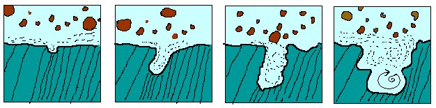
Gletschertöpfe stammen aus der Eiszeit. Sie entstanden durch Schmelzwasser, das durch die Gletscherspalten zum Gletscherbett hin abfloss. Dieses Schmelzwasser vereinigte sich zu Strömen und bildete an gewissen Stellen Wirbel. In diesen Wirbeln herrschten Fließgeschwindigkeiten von bis zu 200 km/h und hohe Drücke. Die Haupterosionsarbeit mit Aushöhlen des Felsbettes leisten dabei der mitgeführte Sand und die Kiespartikel, in seltenen Fällen auch einzelne Findlinge. Die Härte des mitgeführten Gesteins muss gleich oder größer sein als die des Untergrunds. In manchen Fällen findet man in diesen Töpfen Diamanten, so in Südafrika. Primär handelt es sich um den Auftreffpunkt einer Gletschermühle, also einem kreisförmigen Loch bzw. einer Spalte in einem Gletscher (Wikipedia).
Gletschertöpfe sind auch in Deutschland, der Schweiz, in Skandinavien und den USA häufig zu finden. Sie liefern wertvolle Erkenntnisse über den früheren Verlauf und die Ausdehnung von Gletschern.
Der vorliegende Gletschertopf auf einer Höhe von 1000m zwischen den Orten Igls und Lans im so genannten südlichen Mittelgebirge oberhalb Innsbrucks stammt aus der letzten Kaltzeit, dem Würmglazial. Hier trafen der Wipptal- und der Inntalgletscher zusammen und formten eine bis über den Gipfel des Patscherkofels reichende Eismasse, die entsprechend starke Erosionserscheinungen verursachte. So ist auch die heutige rund geschliffene Form des Patscherkofels zu erklären. Der Topf liegt in der Zone der Grauwacken, ein paläozoisches Gestein aus dem Unterkarbon. Die relativ harten, meist dunklen Gesteine stellen eine Klasse von Sandsteinen dar, die aus Quarz, Feldspat (meist Plagioklas), Kiesel- bzw. Tonschiefern und Gesteinsbruchstücken in einer tonigen Grundmasse (Matrix) bestehen. Der Matrixanteil des Gesteins beträgt dabei mehr als 15 %, besteht meist aus Tonmineralen, Chloriten und Glimmern und verursacht die meist dunkel(grün)graue Färbung. Die eiszeitlichen Gletscherströme stammten zum Großteil aus der Zone der Gneise und Glimmerschiefer, also teilweise noch härterer metamorpher Gesteine. Somit ist die Entstehung der Gletschertöpfe (hartes mitgeführtes Gestein in weicherem Untergrund) erklärbar.
Der Cache ist auch von den benachbarten Orten auf mehreren gut beschilderten und leichten Wegen erreichbar!
Logbedingungen:
1. Ermittle den Durchmesser des Gletschertopfs in cm!
2. Vor wie vielen Jahren verschwand das Eis in dieser Gegend?
3. (Optional) Fertige ein Photo von dir oder deinem GPSr und dem Gletschertopf an und füge es deinem Log bei!
Bitte gebt keine Hinweise zur Beantwortung der Fragen in euren logs!
Ihr könnt gleich loggen, bei Problemen - siehe unten:
Logs ohne gültige Antworten oder Fotos werden ohne Kommentar gelöscht!
English version:
Giant's kettles, also known as giant's cauldrons or potholes, are cavities or holes which appear to have been drilled in the surrounding rocks by eddying currents of water-bearing stones, gravel and other detrital matter.
The size of giant's kettles varies from a few inches to several feet in depth and diameter. The most common occurrence is in shields, where there are ancient rocks (granite, gneiss) with different resistance to erosion, so strong pebbles fall in a small cavity and swirl making this cavity wider and deeper. In areas where there are diamonds and quartz rocks, the hardness of these rocks cave potholes and sometimes remain trapped in the bottom of them. Hardness of pebbles must be the same or higher than the bottom of stream where the kettle is forming. That is why these potholes are a good place to find diamonds (the hardest rock in Earth) and also explains the name of some potholes in the Blyde River Canyon of South Africa.
They are also common in Germany, Austria, Switzerland, Scandinavia and in the United States. It appears that water, produced by the thawing of the ice and snow, forms streams on the surface of the glacier, which, having gathered into their courses a certain amount of morainic debris, are finally cast down a crevasse as a swirling cascade or moulin. The sides of the crevasse are abraded, and a vertical shaft is formed in the ice. The erosion may be continued into the bed of the glacier; and, the ice having left the district, the giants kettle so formed is seen as an empty shaft, or as a pipe filled with gravel, sand or boulders. Such cavities and pipes afford valuable evidence as to the former extent of glaciers (from Wikipedia).
The here mentioned giant's kettle is situated at a height of 1000m a.s.l. between the villages Igls and Lans in the so called southern Mittelgebirge above Innsbruck. Here the pleistocene ice masses of the Inn valley glacier and the Wipp valley glacier met, thus forming huge ice walls covering mount Patscherkofel and creating strong erosion. The round shape of Patscherkofel peak is easily recognized as a result of these forces.
The here introduced giant kettle is situated in the Paleozoic greywacke zone situated between the Central Alps and the Mesozoic Northern Calcareous Alps. These relatively hard metamorphic rocks are a variety of sandstone consisting of quartz, feldspar (plagioclase), siliceous and argillaceous slates and rock debris in a clay matrix. It may be cut or ground by some harder gneiss and quartzite pebbles and gravel transported by the pleistocene glaciers coming from the central Alps. Thus, the forming of giant kettles can be easily explained.
Cache location can be accessed on easy paths starting from the surrounding villages (or parking lot).
Logging conditions:
1. Measure the diameter of the giant's kettle in cm!
2. How many years ago did the ice disappear?
3. (Optional) Take a photograph of yourself or your GPSr in front of the giant's kettle and attach it to your log!
Please do not include any hints in answering the questions in your logs
You may log immediately; in case of problems -see below:
Logs without valid answers or photos will be deleted without comment!
FTF: Snaketraveler 
Additional Hints
(No hints available.)