Solano Breezes Earthcache EarthCache
Solano Breezes Earthcache
-
Difficulty:
-

-
Terrain:
-

Size:  (other)
Please note Use of geocaching.com services is subject to the terms and conditions
in our disclaimer.
As an earthcache, there is no “box” or “container” to discover. Rather, with this cache, you discover something about the geology of the area. For more info, consult www.earthcache.org
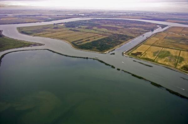
This pullout is just off of Hwy 160 north of the Antioch Bridge and not far from Rio Vista. You likely will only need to share the area with a few bored fishermen. There are turn outs all along this section of the road.
If you are within a 200’ range of these GZ reading, find a parking spot and look around you!
Montezuma Hills (Shiloh) Wind Resource Farm, with its one-hundred white windmills (their blades stretching 122 feet), is located on the hills between Fairfield and the Delta towards Rio Vista, CA.
Installed over the last year, each windmill can generate 1.5 megawatts of electricity, enough to light 1,100 homes. The Shiloh plant will also help the state stay within newly imposed limits on greenhouse gas emissions. "The plant will help offset 380 million pounds of carbon dioxide per year," said Blaine Sundwall of PPM Energy, which is part of U.K.-based Scottish Power. That’s a great goal, since the plant cost over 260 million to build and covers 6,800 acres. Of course only 2% of that acreage is actually dedicated to the sole usuage of the wind turbines. The remaining 98% is also used for farming! The plant will help California meet the recently updated goal of getting 20 percent of its power from renewable sources such as wind energy and solar power by 2010. And it will help keep lights burning, water flowing and businesses transacting in the Bay Area and across the state, PG&E said.
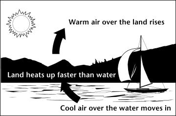
Science of Wind Energy: First off let's talk about wind. What is wind and what causes it? Wind is air in motion. Believe it or not, the sun helps cause wind. The sun heats up the earth, although it heats up the land and water at different rates. The air above the land heats up quite a bit faster. The hot air flows up into the sky and begins to cool. The cooler air begins to flow out over the water. The cooler air begins to settle downward exerting pressure on the air. This pressure creates wind (see diagram).
Geology of Wind Energy: Wind energy requires wind. The ideal place for wind is open plains and hilltops. In fact, California has four wind farms, Altamont Pass; Tehachapi Pass; San Gorgonio Pass; and this new, rapidly growing wind resources area near Rio Vista in Solano County. What is needed geologically for wind energy to be successful? As already mentioned above, you need the sun’s energy heating both the water and the land (both of which are ideally close together).
Landscape of wind: You need a geologic landscape largely devoid of trees and other “wind obstructions." The open plains need to be 93% or more clear to provide the necessary open space for wind energy, while hilltops need to be oly 10% “clear” to provide that necessary wind space, and passes or ravines need to only be 40% clear to provide the necessary wind tunnel. Of course, no one would even think of creating a wind farm in an enclosed valley or forest, since there's no free space!
The landscape in front of you is called the Great Valley Sequence, which is basically a part of the ocean floor that was tipped up and deposited as part of faulting action in this area. You can see the sequence layers in area roadcuts, where layers of sedemented sandstone and gray or black Shale. Since it was formed by an oceanic plate depositing on top of the basaltic continental plate, the great valley sequence is tilted slightly down to the east. In this region, the “ripple” effect of this “crashing” of the two plates has created rolling hills (sedimentary) and a flat plain (the Great Valley Sequence). You will need to determine whether the area you are looking at is a hilltop, plain, or pass for logging requirements below.
Construction of Wind Turbines: The wind turbines are basically made up of 5 main parts: foundation, tower, nacelle, rotors, and the transformer. The wind turns the rotor (or blades), which turns a generator (basically copper wire and magnets) inside of the nacelle, which creates electricity. The nacelle sits on top of the tower. The tower is the long pole that gets the rotors up into the wind currents. The tower sits on top of a foundation full of rebar and over 300 CY of concrete. The transformer sits next to the tower and helps convert the wind into energy.
Environmental Concerns: There have been concerns over birds getting killed by the blades of the turbines in Altamont Pass. Sundwall said PPM Energy has addressed this problem with technology. "Our towers are tubular, not latticed," Sundwall said. "Birds nest in the latticed towers and we theorize that makes them more likely to get hit by the blades as they fly in and out." He said the speed of the revolutions at this plant has been slowed to 11 to 20 revolutions per minute on the theory that the birds can see the blades better.
Logging Requirements:
Send the answers to #1-#4 to me through my geocaching profile.
- First, list the name “GC20EVG Solano Breezes Earthcache” in the first line of your email. Also, list the number of people in your group.
- Second, based on what you can see to the north towards the turbines, what type of GEOLOGY is present? That is, is the area where you see the turbines working a plain, a pass, or a hilltop?
- Third, count the number of turbines (windmills) visible from GZ. Based on your count, how many HOMES can be powered by these visible turbines?
- Fourth, Visit http://www.windpoweringamerica.gov/maps_template.asp?stateab=ca and identify two other areas in California that are ideal wind energy locations.
- (Per current gc.com guidelines, photos are no longer allowed to be required. HOWEVER they are encouraged, since they can help clarify that you have visited the location if your other logging requirement answers are vague). Take a picture of yourself and your GPSr with the windfarm visible behind you. Post the picture with your log.
I will only respond if you have incomplete logging requirements. Go ahead and log your cache
Congrads to HockeyHiker19 for FTF (First to Finish logging requirements)
Resources:
Roadside Geology of Northern and Central California. Mountain Press Publishing.
Solano Energy Blogspot: http://solanoenergy.blogspot.com/2009/08/new-windmills-near-delta-fuel-states.html
ABC News http://abclocal.go.com/kgo/story?section=news/local/east_bay&id=6678128&rss=rss-green-kgo-article-6678128
WindPoweringAmerica.gov: http://www.windpoweringamerica.gov/maps_template.asp?stateab=ca
Additional Hints
(Decrypt)
Trg gur bgure rnegupnpur gung vf IREL arne urer juvyr lbh ivfvg!