From the cache position, you have a
lovely
view of the domes of the South African Astronomical Observatory
(SAAO). Quite a photogenic spot actually, especially with these
special rocks in the foreground which are often
snow-covered
in winter. Be warned – it can get very windy here which can
make it impossible to do the bonus question (see Question 5 below)!
The site is open to the public during the day for
visits,
the ideal opportunity to do this cache (as well as the
other one here.) [I work
for SAAO, based in Cape Town, but often come to work in Sutherland.
I would love to meet you, so feel free to contact me when you come
and do this cache to see if I’ll be here.]
We pick up the geological story well after the sedimentary rock
layers of the Karoo Basin formed, but before the break-up of the
super continent, Pangea (meaning Entire Earth). [If you want
to know how this happened, visit my
Cutting edge
(GC1XGM6) EarthCache, about 100 km south of here.] All the
strata were still horizontal and in tact then, with the surface
probably about 2000m above where you are standing now.
About 130 million years ago this grand continent began to split
up into Gondwana (the southern part) and Laurasia,
then into various smaller pieces, triggering volcanic activity.
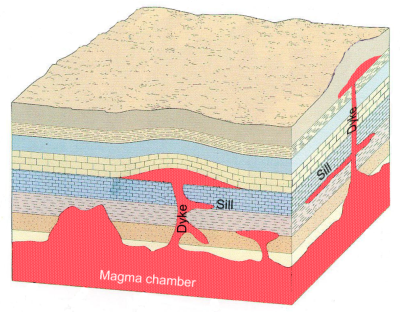
Because of this movement, and due to the enormous pressure of the
molten rock (magma) from below, vertical cracks formed, creating
pathways for the magma to push up into from deep within the Earth.
Quite often the rising magma was unable to reach the surface and
produce volcanoes, but the pressure was so great that the molten
rock was able to lift the higher layers of rock (which was
horizontally stratified and therefore was weakest along horizontal
planes) and squirted horizontally into the gaps made, forming
sheets between the sedimentary layers, sometimes hundreds of
kilometers in extent (see sketch below). These “sills” cooled
quickly through contact with the local rock, solidifying into very
small crystals (unlike, e.g. the deep igneous intrusion of Paarl
Rock, which cooled very slowly and formed large crystals). The
result is a fine-grain granite known as “dolerite” (Greek:
doleros, meaning "deceptive"). The vertical feeder channels
also coagulated in what are known as “dykes”. The sills and dykes
are thus younger than the sandstone and mudstone deposits.
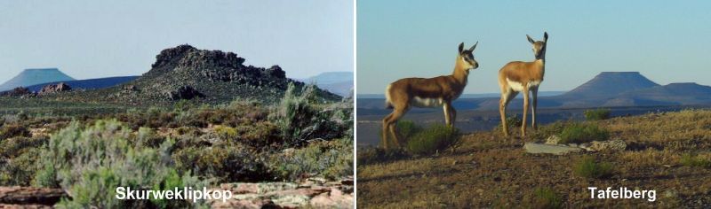
Over the millennia the sedimentary layers eroded away to the
level we see today. However, the very hard dolerite resist
weathering, producing flat top “mesas” (flat tableland with steep
edges), a familiar sight throughout the Karoo. Because the harder
rocks weather more slowly, these hills are in effect held up from
their tops, and only wear down as the softer rocks below undermine
the harder layers. The plateau that you, and the SAAO telescopes
are on, is in fact such a dolerite sill. And if you look NNE, just
past SALT (bearing 19°, 24 km away), you will see a very distinct
flat-topped hill, called Tafelberg (Table Mountain), which is also
a remaining piece of a sill.
There is also a good example of a dyke conveniently nearby –
look NNW (bearing 330°, distance 4.2 km). This rocky outcrop is
officially named Skuweklipkop (directly translated; “Rough Stone
Hill”) although our local astronomers have an equally appropriate
nickname for it (see Question 3 below). This feeder channel would
have created a sill far above it, now entirely eroded away.
You may wonder why I brought you here since these features are
better visible from elsewhere on site, as can be seen in the above
pictures (something to look out for when you drive out). It is
because the surprise I mentioned, is right here! If you are at GZ
(ground zero) – and weather permitting – you are probably sitting
on it! You are amongst a heap of washing-machine-sized boulders.
Now find a fist-sized stone and start tapping these boulders (try
the other boulders too). What do you hear? If you could quickly
learn to play the
lithophone,
we must arrange a rock concert!
But wait ... there’s more! Normally EarthCaches do not involve
any hidden treasures, but for your tapping convenience, I left a
hammer amongst the rocks at GZ. Please hide it again afterwards and
shout if it breaks (you will see that it is home-made).
To appreciate how unique these rocks are, verify for yourself
that
Wikipedia
only lists five such sites worldwide. It is interesting that most
of these sites claim that scientists are still unable to explain
the physical mechanism that cause the rocks to sound like this.
However, my source, Prof Brian Warner, explained: “When the
intrusion of molten rock occurred, the liquid rock cooled so
quickly that the crystals didn’t have time to grow large, with the
result that the dolerite is (a) almost microcrystalline and (b)
almost uniform in constitution. This resembles a metallic
structure. The rocks can vibrate coherently because there are no
internal inhomogenieties to damp the sound waves.” It is
interesting to note that in Afrikaans, dolerite is also referred to
as “Ysterklip” (Iron Rock). It makes one wonder if it was perhaps
the acoustic properties of dolerite that lead to this name.
(Source:
Prof Brian
Warner
Department of Astronomy, University of Cape Town , South Africa
AND
School of Physics and Astronomy, University of Southampton,
UK.)
To claim “Found it” you must email me satisfactory responses to
the following:
Any logs not accompanied by an email will be deleted.
- Send me a picture of you/your party with your navigation device
taken at this spot.
- Search for an example piece of dolerite that broke off,
revealing its internal structure and colour. If you compare this
structure and colour with your average granite kitchen tabletop,
name one similarity and one difference between the two.
- Where do you think the local astronomers’ nickname of “Camel
Rock” for Skurweklipkop originated.
- Say for argument sake that magma was never forced in between
the stratifications at this site, meaning the local geology just
composed of regular sedimentary mudstone and sandstone layering. Do
you think the Observatory could still have been build here? Explain
your answer?
- For a bonus, first download
this video clip
and tell me if you recognise the tune [hint: it fits in with the
purpose of this site]. Then see if you can improve on my attempt by
sending me a sound/video recording of your rock music composition.
[How about a Metallica piece!]
Note: Do not post any spoiler
pictures/hints to this page, even if encrypted.