Hofjes in de Jordaan/Almshouses in the Jordaan Multi-cache
Hofjes in de Jordaan/Almshouses in the Jordaan
-
Difficulty:
-

-
Terrain:
-
Size:  (micro)
Please note Use of geocaching.com services is subject to the terms and conditions
in our disclaimer.
Container en logboek zijn prima op orde.
GCRL Please change logrol when full.
Een wandeling van ongeveer een uur door de Jordaan. Gaat goed samen met een bezoek aan het Anne-Frank huis. Samen met de multi-cache de Rosse Buurt de multi-cache met veruit de meeste favorite points in Amsterdam en omstreken!!
A walk of approximately one hour in the Jordaan area. The Anne Frank house is closeby and can be visited. Together with the multi-cache The Red Light District the multi-cache with by far the most favorite points in the Amsterdam area!!
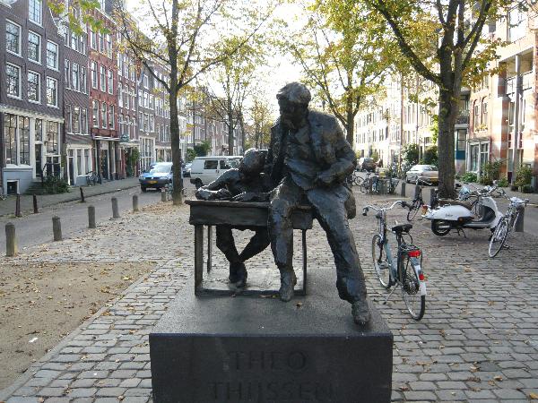
De Jordaan is van Amsterdam wel de meest bekende en bezongen wijk. De Jordaan is een begrip, binnen en buiten Amsterdam. Het wordt geassocieerd met de 'echte' Amsterdammer en volkse gemoedelijkheid. Het begint bij het standbeeld van Theo Thijssen, een schrijver uit de negentiende eeuw die hier geleefd heeft. Loop van het standbeeld in Zuidwestelijke richting. Als je goed gekeken hebt, dan staan de straten van de Jordaan een beetje schuin haaks op de grachtengordel. Bij de aanleg van deze wijk was duidelijk dat de wijk voor de arbeidersklasse zou worden. Om het verschil tussen de rijkere klasse en de arbeidersklasse te benadrukken werd de wijk haaks op de grachtengordel gebouwd: Het moest namelijk goed duidelijk zijn dat je 'een andere buurt' in kwam.
The "Jordaan" is one of the most famous areas in Amsterdam. It is mentioned in many songs. Many "real" Amsterdam celebrities come from this area. Rembrandt van Rijn, the painter, lived his last years in poverty in this area. Also "Jan Klaassen en Katrijn", the two most famous puppets in Holland that every Dutch child will know, are characters that once lived in this neighbourhood.
Start at the statue of Theo Thijssen, a Dutch writer from the nineteenth century and proceed in South-west direction. The roads in the Jordaan are with a different angle with respect to the canals. This has been done to indicate that the 'lowerclass' Jordaan-area was different from the 'upperclass' canal-area. The Jordaan was originally built for the poor people in the city.
Ga naar/Go to waypoint 1: N 52°22.828’ – E004°53.146’
Onduidelijk is hoe de Jordaan aan zijn naam komt. Het meest genoemd is dat het een afgeleide is van het Franse Jardin (tuin). Je vindt hier ook veel straatnamen met bloemen. Een andere verklaring zit in het feit dat de Prinsengracht Jordaan werd genoemd, later werd de wijk achter de Prinsengracht daarmee bedoeld.
Ga hier naar rechts de eerste Goudsbloemdwarsstraat in en ga meteen de eerste straat weer links. Op de hoek hangen hoog op de gevel een aantal vogelhuisjes. Hoeveel vliegopeningen kun je tellen? Het antwoord is A. Neem het juiste huis, het aantal vogelhuisjes is oneven en kleiner of gelijk aan 15!
It's not clear where the name "Jordaan" comes from. It might come from the French word Jardin (which means garden). You can see that all names of the streets in the Jordaan are flowers. Also a relation which the middle-east river Jordan is possible and in the past, one of the canals: the Prinsengracht was referred to as the Jordaan.
Go to the right and turn directly left on the next crossing. The first house to the left has a number of birdhouses. How many openings in the birdhouses can you detect? The answer = A. Take the right house, the number of birdhouses is odd and smaller than or equal to 15!
Ga naar/Go to waypoint 2: N 52°22.841’ – E 004°53.043’
Hoe traditioneel! Nog gewoon een aparte slager en bakker in de wijk. Geen grootschalige winkelcentra, maar kleinschaligheid dus. Op welk huisnummer is de bakkerij-winkel? Het antwoord is B. (om het makkelijk te maken: B is een veelvoud van 8)
How traditional! No large supermarkets here but a bakery and a butchery. What is the number of the bakery-shop? The answer = B. (To make it easier: B is a multiple of 8)
Ga naar/Go to waypoint 3: N 52°22.928’ – E 004°53.025’
Je staat hier vlak bij het hofje op de Palmgracht. De naam van het hofje is "het Raepenhofje". De Jordaan staat bekend om zijn hofjes, er zijn er enkele tientallen, waarvan nog een beperkt aantal open voor publiek. Deze is dat wel. Ga er dus naar binnen, maar houd wel je gemak!
De ingang is aan de Palmgracht: een dwars gebouwd poortgebouw met een klein rond poortje met daarboven een prachtige jaartalsteen . Het Raepenhofje is gesticht en gebouwd door Pieter Adriaensz. Raep (1581-1666) met het geld van de erfenis van zijn vader Adriaen Pietersz., overleden in 1647. Er wordt beweerd dat de Raeps het hofje hebben gesticht uit dankbaarheid voor de Vrede van Münster, maar waarschijnlijker is dat Raep het hofje stichtte om onsterfelijk te worden (daar hij geen nageslacht had).
Het poortje heeft een sluitsteen met de initialen van Raep (P.A. is Pieter Adriaensz) en de raap daaronder staat voor de familienaam. Na binnenkomst ziet met een bord met de tekst “Salig syn de vreedsamen want sy sullen Godts kinderen genaamt worden”. Dit hofje was bedoeld voor protestantse dames. In het reglement staan o.a. regels m.b.t. het ophangen van wasgoed. Niemand minder dan Vondel vervaardigde op het Raepenhofje het volgende gedicht:
Peter Raep, de trezorier
Boude uit mededogen hier
‘t Weduwen en Weezenhof
Men gebruik het tot Godts lof
Boven de rode ingangsdeur van het Raepenhofje vind je een jaartal in een prachtige steen.
C=De helft van het tweede cijfer in dat jaartal.
You are now close to the almshouse: "het Raepenhofje". There are a lot of almshouses in Amsterdam, but only a limited of them are open to the public. This one is. Go inside, but be quiet!
The entrance is on the Palmgracht. You see a small red door with above it a beautiful stone with a year on it. Het Raepenhofje is founded by a wealthy treasurer of the city: Pieter Adriaensz Raep, with the money of his father. There is a gable with the initial of mister Raep (P.A.) and below it, refering to its name 'een raap' (a turnip) which is a vegetable, much eaten in the middleages.
Above the red door that leads to the Raepenhofje you will find a beautiful stone with a year on it.
C = the second number in the year, divided by two
Ga naar/Go to waypoint 4: N 52°22.914’ – E 004°52.923’
En meteen door naar/Direct to waypoint 5: N 52°22.775’ – E 004°52.862’
Je bent nu bij de ingang van de Karthuizerdwarsstraat. Vlak ervoor is bij het tweede huis aan de rechterkant een gevelsteen. Dat is een.....
You are now at the entrance of the Karthuizerdwarsstraat. Just before this street, to the right you see a gable. That is a.......
- D=2, een ganzeveer / a goose-feather
- D=4, een zwart paard / A black horse
- D=5, een gouden muntstuk / a gold coin
- D=7, een varken / a pig
Ga naar waypoint 6: N 52°22.728’ – E 004°52.900’
Je staat nu bij een volgend hofje. Dit alleraardigst hofje is waarschijnlijk het grootste van Amsterdam. Het werd in 1650 door stadsarchitect Daniël Stalpaert opgetrokken. Officieel heet het het Huyszitten Weduwenhofje. Het werd in 1650 gebouwd op het terrein van een vroeger klooster. De opdracht tot bouw kwam van de Huiszittenmeesters, vooraanstaande kooplieden die 'huiszittende armen' ondersteunden met turf, levensmiddelen en soms huisvesting. Aan de straatzijde hebben de huizen witte drooglatten. Het hofje maakt een ruime indruk door de twee bleekvelden en de grote binnenplaats. Binnen het hofje zien we boven de toegangspoort het Amsterdamse koggeschip, het grootste handelsvoertuig in de middeleeuwen. E = het aantal waterpompen-complexen in het hofje. (het antwoord is niet 4)
You are now at the next almshouse. This nice almshouse is probably the biggest in Amsterdam. It was founded by Daniël Stalpaert in 1650. On the streetside you can see a wooden contruction at the top windows. These were for the laundry. Also the inside of the almshouse has two lawns for bleaching the laundry.
E = the number of water pumps complexes you can see inside the almshouse. (the answer is not 4)
Ga naar/Go to waypoint 7: N 52°22.632’ – E 004°53.037’
Tegenover nummer 4 kun je het Claes Claeszhofje in. Eigenlijk zijn dit drie in elkaar verweven hofjes. Het is ontstaan, doordat de lakenhandelaar Claes Claeszoon Anslo drie huisjes had gebouwd in een tuin achter de Egelantiersstraat. Hij liet daar vanaf 1615 oude mensen gratis wonen. De bebouwing is later uitgebreid. Meteen na de ingang rechts heb je het zwaardvegershofje.
Opposite number 4 you can enter het "Cleas Cleasz. hofje". This almshouse in fact consist of three almshouses connected to each other. It started with a few houses in the garden of houses in the Egelantiersstraat and it developed further over time. Look for the nice and quiet space directly right after you enter the almshouse. This is called the 'zwaardvegershofje'

Kijk even verder rond en verlaat de hofjes via een andere uitgangop de Egelantierstraat. Vlakbij waar je nu staat, zie je een gevelsteen. Wat zie je daar?
Leave the almshouse through the entrance, beacause the other entrance is recently closed. Go left and left again. You are now on the Egelantiestraat. You can find the 'closed' exit of this almshouse here. Near that exit on the Egelantierstraat, you can see a gable. What can be seen?
- F=1, een ganzeveer / a goose-feather
- F=4, een zwart paard / A black horse
- F=5, een gouden schaar / golden scissors
- F=7, een varken / a pig
Ga naar/Go to waypoint 8: N 52°22.595’ – E 004°52.931’
Je loopt over de Egelantiersstraat en je ziet nu links in de staat de Westertoren. Daarover later meer.
You are walking on the Egelantierstraat. At the coordinate you can see left the Westertoren. Later more about this tower.
Ga naar/Go to waypoint 9: N 52°22.535’ – E 004°52.821’
Je staat hier weer voor een hofje. Het is vrij toegankelijk, alleen gesloten tussen 6 uur 's avonds en 7 uur 's ochtends en op zondagen. Als je naar binnen kunt, let dan eens op het fraai betegelde 'halletje' waardoor je binnenkomt.
Wat is de naam van dit hofje?
You are in front of the next almshouse. It can be entered freely, but it is closed between 6pm and 7am and on Sundays. If you are able to enter, look at the nice tiled hall.
What is the name of this almshouse?
- G=2, Sint-Pietershofje
- G=3, Sint-Anna's hofje
- G=4, Sint-Monica hofje
- G=5, Sint-Andries hofje
Ga naar/Go to waypoint 10: N 52°22.516’ – E 004°52.850’
Op deze hoek bevindt zich een gezellig cafe. Wat is de naam van dit cafe?
On the corner you can find a nice bar. What is the name of the bar?
- H=1, De mooie Lelie
- H=3, Café blanke Lelie
- H=5, Lelietje van Dalen
- H=7, De nieuwe Lelie
Vervolg de tweede Lelie Dwarsstraat voor een kort stukje en ga linksaf de Bloemgracht op Als je de Bloemgracht uitgelopen bent loop je zo'n beetje tegen de Westertoren aan, aan de overkant van het water. Vlak in de buurt, naast de Westertoren is ook het Anne Frankhuis. Voor de liefhebbers kun je daar een uitstapje naar maken. Het huis van Anne Frank ligt op coordinaat: N 52°22.508’ – E 004°53.030’. Houd rekening met lange wachtrijen, het is hier vaak druk.
Zoals gezegd: De Westertoren is echt de toren van de Jordanezen. Veel bezongen en ook religieus (in een verleden) het centrum van de mensen. De echte kerk van de Jordaan is de Noorderkerk. Die staat helemaal in het Noorden van de Jordaan, vlak bij het standbeeld van Theo Thijssen en was dus niet zo centraal gelegen als de Westerkerk.
Wij gaan naar het één na laatste waypoint.
Continue on the Tweede Leliedwarststraat and go left on the Bloemgracht. You can see the Westertoren again at the end of the Bloemgracht, on the other side of the water. Very close, also on the other side of the water is the Anne Frank house. For those who want to visit it, here are the coordinates. N 52°22.508’ – E 004°53.030’. Know that occasionaly (long) queues occur.
As said, although the tower is not positioned in the Jordaan, the Westertoren is considered to be the real tower of the people in the Jordaan. In many songs the Westertoren is mentioned and also (in the past) this was the religious hart of the area. There is a church in the Jordaan, the Noorderkerk, close to the statue of Theo Thijssen where we started the tour. This church is in the North of the Jordaan, the Westerkerk is far more centrally positioned.
We continue for the almost final waypoint.
Ga naar/Go to waypoint 11: N 52°22.562’ – E 004°53.061’
Dit is de brug die ons weer uit de Jordaan laat gaan. Je kunt dus ook zien dat de Westertoren niet in de Jordaan staat. De brug is ook het begin van een nieuwe gracht, haaks op de Prinsengracht. Welke?
This is the bridge between the Jordaan and the canal district. You can see here that the Westerkerk is not positioned in the Jordaan. The bridge is the start of a new canal, perpendicular to the Prinsengracht. Which?
- J=1, De Leliegracht
- J=3, De Anemoongracht
- J=5, De Botengracht
- J=7, De Singel
Zo, je hebt nu alle gegevens beschikbaar. Bereken onderstaande coordinaat en ga daar naar toe voor de finale! Je vindt de stash in de buurt van de Noorderkerk.
You have now all information available. Do some simple calculations and proceed to the coordinate below! You will find the stash near the Noorderkerk.
Ga naar/Go to waypoint 12: N 52°(A+H).(C+D)(D+D)(B-H)’ – E 004°5(E+F).JGE’

een banner met dank aan AmezorC
en hier de html-code voor de banner
<a href="https://www.geocaching.com/geocache/GC20DV1_hofjes-in-de-jordaan-almshouses-in-the-jordaan" target="_blank"><img src="https://s3.amazonaws.com/gs-geo-images/adb54c62-62a9-47f4-88af-f5f522216ee2.jpg" alt="Hofjes in de Jordaan" title="Hofjes in de Jordaan" width="200" height="50"></a>
Additional Hints
(Decrypt)
nna qennq npugre ryrxgevpvgrvgfxnfg/ba n jver oruvaq ryrpgevpvgl obk
Nyf ybtobrx iby vf, znt qng qbbe rra vrqre ireinatra jbeqra!! Tennt mrysf.
Arrz rra avrhj ybtobrx zrr nyf wr xbzg.