Valley of Desolation EarthCache
-
Difficulty:
-

-
Terrain:
-

Size:  (other)
Please note Use of geocaching.com services is subject to the terms and conditions
in our disclaimer.
|

|
| |
|
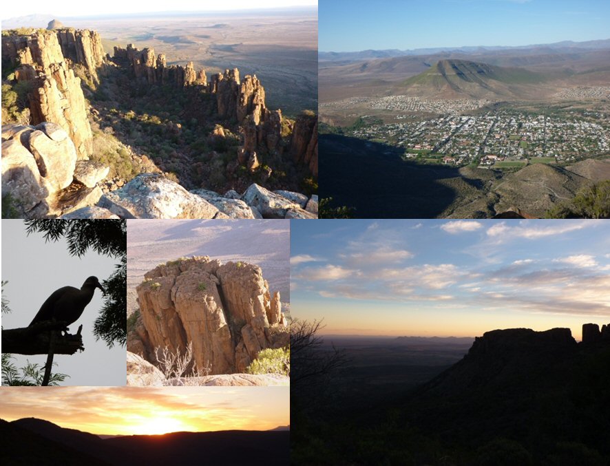
The Valley of Desolation was proclaimed National Heritage Site. It lies within the Camdeboo National Park.
At the time when the earliest Karoo rocks were being deposited, southern Africa formed part of Gondwana. Southern Africa was positioned in the polar region and was covered by ice. As the continent moved away from the pole the climate warmed. Large rivers flowed into the sea from an ever-expending fold-mountain chain to the south, depositing sediments in deltas and on the sea bed.
Northward-flowing rivers arising from these mountains deposited thick layers of sand and mud over southern Africa for at least 300 million years. These sediments now form the sandstones and mudstones which are so well exposed in the Graaf-Reinet area.
From 180 million years ago the Gondwana supercontinent began to break up. This was marked by widespread volcanic activity resulting in extensive lava flows. Not all of the lava generated deep in the earth's crust found its way to the surface. In the process of eruption, molten lava (magma) spread both horizontally between rock layers and vertically through fissures and eventually crystallized underground to form dolerite (diabase). If the dolerite crystallized between layers of sedimentary rock it is known as a “sill”, while vertical dolerites with cross rock layers are known as “dykes”.
Sills and dykes are plentiful throughout the Karoo, and, as dolerite is hard and resistant, it forms the characteristic flat tops of many Karoo kopples.
The selective erosion and weathering of the dolerites along joints and cracks have resulted in the impressive valleys cliffs and huge columns which can be seen in the Valley of Desolation.

To do this cache you have to do the following things:
- Leaving the car at S32 15.872 E24 29.597 a short walk leads you to the brink of the Valley. The sheer cliffs rise to a remarkable height above the floor of the valley which is strewn with huge rocks in piles and mighty columns.
- Take a picture at S32 15.993 E24 29.622 with you and/or your GPS or personal item and add it to your log. Logs without picture will be deleted.
To log this cache, first send us the answers of the following two questions via gc-message center. In the second step you can log the cache with your photo. We will contact you if your answer is wrong.
- Estimate the altitude (in meters) of the greatest rock pinnacle you can see from this position.
- In southeast you see a Karoo-typical mountain. How is it called?
|
Have a lot of fun!
last update 7.11.2009
Additional Hints
(No hints available.)