A Window on the Canyon EarthCache
-
Difficulty:
-

-
Terrain:
-
Size:  (other)
Please note Use of geocaching.com services is subject to the terms and conditions
in our disclaimer.
From the North Rim visitor's center, a 23 mile scenic drive takes you to Cape Royal and Angel's Window. The Window is the only easily accessible arch at the Grand Canyon. To log this cache, please visit the site, learn about its geology, and submit your logging answers as described below.
The North Rim offers only limited views of the Colorado River, whose erosion formed the Canyon that we know today. One of the most dramatic spots to see the river is through the arch at Angel's Window, where the sweeping turn at Unkar Delta is visible below.
The Arch
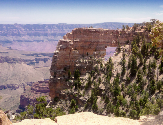 Kaibab Limestone is the current top of the Grand Canyon and is composed mostly of a sandy limestone, with some sandstone and shale thrown in for good measure. This means that it was probably formed in a shallow sea and rose as the meeting of the the North American and Pacific Plates pushed the land up. During the uplift of the Kaibab Plateau, the pressures of the earth caused the rock to fracture, forming vertical joints that intersected with the horizontal bedding planes.
Weathering (rain, freezing, thawing) eroded along the vertical joints of the limestone and the horizontal bedding planes to form a hole and enlarged to form the arch itself, a natural bridge that extends out over the Canyon. From certain viewpoints, the Colorado River can be seen through the window that the arch provides.
The coordinates will take you near the trailhead, from there walk the short path from the parking area to the Window itself.
Logging Requirements
Answer the following questions based on what you have observed or learned. Send your answers through my geocaching profile before logging this earthcache as a “find.” I regret having to say that logs without answers will be deleted. Please email me through my profile rather than use the message center.
- Look for a spot where you can see the Colorado River and record your gps coordinates..
- How many horizontal bedding planes do you see above the arch?
- Follow the trail to the overlook on top of Angel's Window. Based on your observations here, how wide do you think the arch to be?
- Why do you think this arch is unique to this area of the North Rim?
Photo Requirement: The trail offers some beautiful views of the arch -- and the arch itself forms a wonderful scenic location. Post a picture with your log showing the arch or taken on top of the arch. If you are not in the photo please include your gpsr, a personal item, or an informational sign in the picture (as permitted under the June 2019 guidelines).
Park Information
When visiting this earthcache, please stay on the designated trails and take care to leave nothing behind. The walk to Angel's Window is short, but be sure to bring water when the weather is hot.
The North Rim Visitor Center, as well as lodging and camping within the park, is open from mid-May through mid-October. Roads are closed during the winter due to snow. The National Park Service can assist you in planning your visit.
For More Information
The National Parks service provides an overview of the Canyon's Geological Formations as well as Geologic Views that will enrich your understanding and visit to the area. The geology of the area offers a unique look into ages of the earth. You can also learn more about the North Rim Geology from Anabelle Foos of the University of Akron.
This map might be helpful in planning your visit to the North Rim, Angel's Window, and Cape Royal.
Additional Hints
(No hints available.)