Its the Fault of Bright Angel EarthCache
Its the Fault of Bright Angel
-
Difficulty:
-

-
Terrain:
-
Size:  (other)
Please note Use of geocaching.com services is subject to the terms and conditions
in our disclaimer.
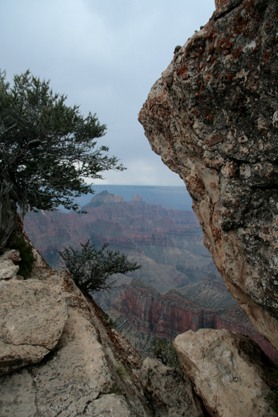
This was the first earthcache approved at the Grand Canyon. From the Visitor's Center at the North Rim, walk the trail to Bright Angel Point, with spectacular views of the Canyon and its geological history. To log this cache, please visit the site, learn about its geology, and submit your logging answers as described below.
The listed coordinates take you near the start of the trail to Bright Angel Point. As you walk the short .25 mile trail, you may see fossils imbedded into the Kaibab limestone; hear the sound of water at Roaring Springs Canyon to your left; or notice the transition from the forests of the plateau to the pinyon and juniper on the canyon slopes as plants adapt to the changing conditions of the geology found here. You can download the trail map or the Park Service trail brochure That will help you on your way. The brochure will be particularly helpful. You will want to note points along the trail that will allow you to log this cache as a find.
Midway along the trail, look to the right, across the Transept Canyon. A 1991 landslide of Coconino Sandstone cascaded into the Canyon, leaving debris across the walls. The slide shows that the erosional process that formed the area is still at work and can lead to rapid changes.
Marine fossils can also be seen at various points along the trail, including the steps following Transept Canyon overlook and the bench near the end of the trail. These fossils show the remarkable uplift that started around 75 million years ago as oceanic plates off of the West Coast (in Utah) slid under the North American plate. The Colorado Plateau was lifted around two miles and subsequent rivers began forming the canyon we see today.
 When you reach the end of the trail, look out to the South Rim, 10 miles away. The uplift that occurred here placed the North Rim around 1000 feet higher than the other side of the Canyon.
The depths of the canyon record events that stretch our understanding over a period of nearly two billion years, almost halfway back in the earth's history. The walls of the canyon are much more than layers of rock, but show the rise and fall of oceans and continents. They record a journal of the earth, from the appearance of trilobites (the first creatures in the fossil record that have eyes) to reptiles that wandered on ancient sand dunes.
Though invisible at Bright Angel Point, the Colorado River is the erosive force responsible for the depth of Grand Canyon. Each kind of rock within the canyon erodes in its own manner. Shales erode to slopes. Harder sandstones and limestones tend to form cliffs. The extremely hard metamorphic rocks at the bottom of the canyon produce the steep-walled inner gorge.
Over the past 5-6 million years, the river has carved a canyon one mile deep. However, it does not act alone. Erosion from other sources: freezing and thawing, heating and cooling, storms that have battered the North Rim, all play a role in forming what you see from the Point.
These forces include the faults that can be seen cutting through almost every geologic layer of the Canyon. Faults are fractures in the earth along which movement occurs. In particular, the Bright Angel Fault stretches across the Grand Canyon from the south through Bright Angel Canyon, which was formed through erosion along the fault, until it terminates near the North Rim. The Bright Angel Fault is still active and has produced small earthquakes that visitors sometimes feel.
Logging Requirements
Answer the following questions based on what you have observed or learned. Send your answers through my geocaching profile before logging this earthcache as a “find.” I regret having to say that logs without answers will be deleted. Please email me through my profile rather than use the message center.
Questions on the Trail
- Look at the Transept Canyon landslide on your way to the Point. Briefly describe the slide area (you can note the color, estimate the size, the type of rock, or describe any other thing that you notice about it).
- As you walk down the trail did you find any fossils? Describe what you find. What is their average size? Record the coordinates of the spot where you found the fossils and provide as specific information as you can. The trail brochure linked on this page will help you identify locations where fossils can be found, including near the bench at the end.
- The action of the faults and effect of erosion continue. What factors do you notice during your visit that slowly causes erosion? What kinds of changes, if any, do you think might occur at the Point over time?
Photo Requirement
Post a photo with your log taken at the overlook at the end of the trail. Please include you, your gpsr, a personal item, or the informational signs in the photo. Note that current (June 2019) guidelines no longer require such photos to be optional.
Park Information
When visiting this earthcache, please stay on the designated trails and take care to leave nothing behind.
The walk to Bright Angel Point is short. but be sure to bring water when the weather is hot and take care in storms.
The North Rim Visitor Center, as well as lodging and camping within the park, is open from mid-May through mid-October. Roads are closed during the winter due to snow. The National Park Service can assist you in planning your visit.
For More Information
The National Parks Service has an excellent brochure of the Bright Angel Trail that will help guide your way along it.
The Park also provides an overview of the Canyon's Geological Formations as well as Geologic Views that will enrich your understanding and visit to the area. You can also learn more about the North Rim Geology from Anabelle Foos of the University of Akron.
Additional Hints
(Decrypt)
Genvy oebpuher