|
The same geological forces that have created the
mountain ranges of Crete also created a large number of truly
remarkable gorges throughout the island.
The geological composition of the island and
centuries of seismic activity have caused it to be literally
honeycombed with an estimated 3,500 caves, many of which are of
extreme archaeological and religious significance. In the past and
even more recently, caves were used by Cretans as places of refuge,
cult sites and centres of resistance to invaders. There are
believed to be over one hundred churches in caves around the
island. According to legend, the Dikteon Andron on the Lassithi
plateau was the birthplace of Zeus, the supreme deity who later
grew up in the Ideon Andron on Mount Psiloritis.
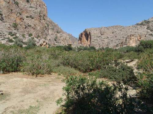
The Agiofarango Gorge is situated in the south of Odighitria
Monastery and was formed by two streams, one of them begins in the
north-northeast at Ghialomonochoro, and the other in the northeast,
at Odighitria. The two streams meet near Aghia Kiriaki Church and
end up at Porofarango, which marks the beginning of the Agiofarango
Gorge, which in turn leads to the Libyan Sea. A small enchanting
beach frames the gorge's debouch.
Many visitors to the Cretan gorges are wondering
how these gorges were formed. Since the late Miocene period, 5 to
10 million years ago, the intense uplift of the whole Cretan area,
due to plate tectonics, accelerated karstic weathering, forming
these many gorges and caves and plateaus.
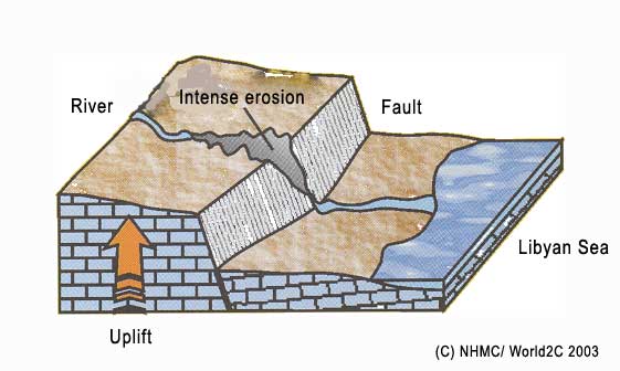
The gorges are formed mainly in carbonate rocks,
i.e. limestone and marble, as a result of continuous land uplift
and erosion by water of the rivers. The land uplift is usually
caused by faults, or 'cracks in the earth':
Early stage: Coastal limestone planes
crossed by a river, which brings rain water and melted snow down
from the mountains:

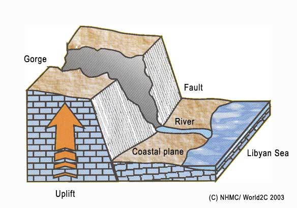
Middle stage: The fault or crack is
breaking, due to geological uplift and pressure. A gorge is
beginning to be formed. The river in its bed causes immense
erosion:
Final stage: Immense erosion by the river
and rising of the stone floor continues, widening the gorge. This
can be seen at most of the gorges in Crete now, like at Samaria and
Imbros gorge. Sometimes a wide coastal plane is formed, like in
Frangokastello, Sfakia:
Tasks to do
As usual for an EarthCache there is no logbook at
the coordinates! To log this cache, please follow the trail and
answer the following questions, with help of the signs along the
way.
You need no Internet to solve the Questions.
1.) How high is the open conical dome inside the Ghoumenospilio
Cave?
2.) What is the meaning of the name Agiofarango in english?
3.) Make a picture of you with your GPS on the following
coordinates N34 55.780 E024 46.747
The Answers you will need as a prefix for the E-Mail Address.
Example: if the height is 14m and the name would be "Gorge of
Geocacher" the E-Mail Address would be:
14_gorgeofgeocacher(at)geo-cacher.com
Send your answers to following E-Mail-address:
(answer...)(at)geo-cacher.com
If your answer is right, you’ll get the log permission
automatically per E-Mail. Please do not log without the permission
otherwise I will delete your log.
|