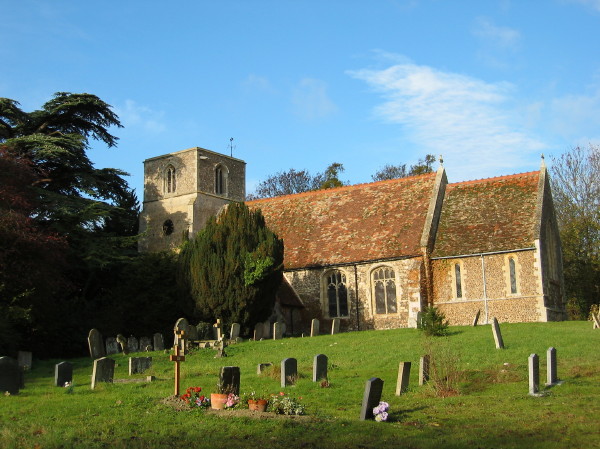
St Giles from
the south.
Tadlow is a
picturesque village situated in rural South Cambridgeshire about
6.5 miles north-west of Royston. Its name comes from the
Anglo-Saxon chieftain Tada and the word hlaw
meaning "hill" or "burial mound". Trippa-hlaw
(Triplow), is similarly named after another chieftain's final
resting place.
Tadlow sits between two ancient routes that run broadly
east-west. One runs past the church a little way to the north,
following a line from Wrestlingworth, past the derelict Clopton and
along the present road through Croydon. The other runs alongside
the River Cam which forms Tadlow's southern boundary
today. These important tracks were known as the "Ridgeway" and
"Portway" in the 14th and 15th centuries and the "Upper-" and
"Lower Cambridge Way" in the 18th century. In 1826 the
Cambridge–Biggleswade turnpike (now the B1042) was built,
abruptly separating Tadlow from its
church.
Tadlow High Street is a mainly
post-1960's development with a few 19th century survivors; there's
little hint of an ancient settlement here. Tadlow's prosperity has
waxed and waned over the last thousand years but it was never
abandoned like nearby Clopton. The Domesday Book recorded 28
peasants in 1086. From there, the population grew - peaking
in around 1300 - but then started to fall. The Black Death
would have taken a toll and perhaps, as happened at Clopton,
labour-intensive arable farming gave way to wool production in the
1500's. After 1660 the number of buildings had certainly declined
and by 1750 only 3-or-4 farms were left, with a few more scattered
across nearby fields. The 19th century saw an improvement, no
doubt helped by that new road; from 13 houses around 1801 to about
30 just 50 years later. Most of today's dwellings appeared in
the 1970's between groups of cottages surviving from the 19th
century. Of course, one medieval building survived throughout:
the church, hidden away above the B1042 and quietly watching the
drama below.
St Giles,
formerly St. John the Baptist, was known by its current
name in 1748. It is built of the usual flint rubble with
clunch dressings, and comprises a chancel, nave, south porch
and west tower.
A curious feature of St Giles is
that its orientation is not consistent along its length. Since
very early times, churches were orientated so that the congregation
faced east. Opinions differ as to why. Perhaps it was
out of deference to the Holy Land (Jerusalem in particular), or the
Orient (thought to be the origin of Man), or sun worship (which
early Christianity cleverly commandeered - think of
"Sunday"). It is suggested that many churches were aligned to
the rising sun on their patron saint's day. Regrettably,
there is only limited evidence to support that intriguing
notion.
 St Giles' nave and chancel were built in the 13th century and were
probably aligned to adjoining field boundaries. The tower was
not built until after 1400 and is more correctly oriented to the east. The deviation is
small but you can just see it if you stand to the rear of the
tower, looking along the back wall of the nave. As far as I
know, such corrections are uncommon, at least locally. Most
churches have had major components added or completely rebuilt over
their lifetime, yet the original building line is normally
respected.
St Giles' nave and chancel were built in the 13th century and were
probably aligned to adjoining field boundaries. The tower was
not built until after 1400 and is more correctly oriented to the east. The deviation is
small but you can just see it if you stand to the rear of the
tower, looking along the back wall of the nave. As far as I
know, such corrections are uncommon, at least locally. Most
churches have had major components added or completely rebuilt over
their lifetime, yet the original building line is normally
respected.
The church is open to visitors and
is worth a look inside. The interior is a curious mixture of
medieval simplicity and robust Victorian decoration. As one
of the references suggests, the Victorian red tiles seem out of
place but they do remind us that these old churches survive today
only through continual maintenance and occasional restoration.
Without such care, St Giles would have long gone the way of all
other contemporary buildings in this little hamlet.
References:
Tadlow, A Dictionary of British
Place Names. Extract online at: http://www.encyclopedia.com/doc/1O40-Tadlow.html
Tadlow, St
Giles: http://www.druidic.org/camchurch/churches/tadlow.htm
Tadlow, British History Online: http://www.british-history.ac.uk/report.aspx?compid=66748
Orientation of Churches: http://www.newadvent.org/cathen/11305a.htm and
http://www.indigogroup.co.uk/edge/chorien.htm
The
Cache
The church is set well
back from the road but please ensure that children and
dogs are properly supervised, especially when leaving or entering
the site. Boots or wellies are strongly recommended and this is
probably not one to do after dark.
I found that GPS stability is
heavily affected by the trees here. Wait for it to settle and look
around if you don't immediately find what's described. Answers to
the following questions can all be found outside the church
and will enable you to find the cache location.
1. To ensure you've safety in
mind, what is the legal speed limit along this stretch of the
B1042? = A0 mph
2. Go to N52 06.733 W000 07.936
– William and Mary Ingrey both died in December 1906. How
many days apart? = B days
3. Go to N 52 06.725 W000 07.920
– RS scratched his mark here. In which year? =
1CD7
4.
Walk around the church and count the metal ventilation
grills at ground level, including the one that's covered up. =
EF
5. Look around for a living
commemoration of a VJ Day anniversary. What two numbers are on the
plaque? GH
In true
Bill&Ben style, the sum (A+B+C+D+E+F+G+H) should
equal 26. The cache can now be found at:
N52 06.(A+1)(C-E)(B+F+H) W000
07.(G+F)(G+D)(C+F)
If anybody would like to
expand this series please do, I would just ask that you could let
Sadexploration know first so he can keep track of the Church
numbers and names to avoid duplication.