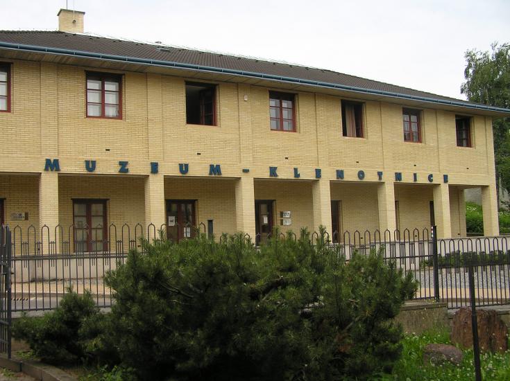
Drive-In Cache in Nova
Paka
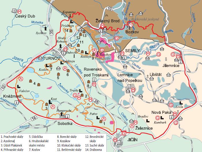
Ceský
ráj
predstavuje skutecnou geologickou ucebnici.
Území o rozloze
necelých 700 km2 zahrnuje širokou škálu geologických fenoménu,
paleontologické, mineralogické a archeologické
lokality
i historické
památky. Do prestižního seznamu síte evropských geoparku byl
zarazen v ríjnu 2005.
Území bylo v
prubehu témer 500 miliónu let trvající historie Zeme opakovane dnem
jezer a morí, nekolikrát zde probíhala sopecná cinnost. Usazeniny
druhohorního more vytvorily základ dnešních
pískovcových
skalních mest. Spolu se zdvihy a poklesy obrovských bloku zemské
kury probehla vrásnení hornin. Na zemský povrch
pusobily
prírodní síly - vítr, voda, mráz a slunce. Výsledkem je krajinas
divokými skalami, sopkami, rekami, romantickými údolími,
lesy,
loukami a
rybníky. Pusobením vody pod zemským povrchem vznikly unikátní
Bozkovské jeskyne se zajímavými krasovými jevy.
Pestré
geologické procesy vytvorily ložiska rud železa, medi a rtuti,
nalezište drahých kamenu, uhlí, stavebního kamene,
pokrývacských
bridlic,
sklárských písku, vápencu, hrncírských a cihlárských hlín. Zdejší
zpracování drahých kamenu patrí k nejstarším v Evrope.
Zajímavý
je i výskyt
zkamenelých zbytku rostlin a živocichu. Prumer amonitu,
druhohorních hlavonožcu, dosahoval až 2 metru. Na území
geoparku
se nachází
stovky archeologických lokalit. Nejhodnotnejší cásti geoparku leží
na území Chránené krajinné oblasti Ceský ráj.
Geopark Ceský
ráj prináší obraz o geologické historii Zeme a zároven dokládá
význam prírodních podmínek pro ekonomický a kulturní
rozvoj
lidské
spolecnosti v prubehu nekolika tisíciletí.
The Bohemian
Paradise represents a real
geology textbook.
The territory of almost 700 km2
includes a whole range of geological phenomena, palaeontological,
mineralogical and archaeological locations and also historical
monuments. It was listed in the prestigious
list of the European Network of
Geoparks in October 2005. In the course of the Earth history,
lasting for almost 500 million
years, the area was repeatedly the
bottom of seas and lakes and volcanoes erupted here several times.
The sediments of the Mesozoic sea
created the base of the current
sandstone “rocky towns”. Together with the eise and fall of
enormous blocks of the Earth’s crust folding
of rocks occurred. This resulted
in the landscape with wild rocks, volcanoes, rivers, romantic
valleys, forests, meadows and ponds. The
impact of water under the Earth’s
surface gave rise to the unique Bozkov caves with interesting carst
phenomena.
Various geological processes
created ore deposits of iron, copper and mercury, deposits of
precious stones, coal, masonry stone, slate
for roofs, sands for glass works,
lime and potter’s and brick clay. The local processing of precious
stones has one of the longest histories in
Europe. The occurrence of
petrified remnants of plants and animals is of interest too. The
diameter of ammonites, cephalopods from the
Mesozoic sea, reached up to two
meters. The most precious parts of the geopark are located within
the territory of the Protected Landscape
Area Bohemian Paradise. Geopark
Bohemian Paradise illustrates the geological history of
the
Earth and at the same time proves
the importance of natural conditions for the economic and cultural
development of human society in
the course of several thousand
years.
Das Böhmische
Paradies stellt ein
tatsächliches geologisches Lehrbuch dar. Das Gebiet mit
einer
Fläche von fast 700 km2 umfasst
eine breite Skala geologischer Phänomene, paläontologische,
mineralogische und archäologische Lokalitäten und historische
Denkmäler. In das Prestigeverzeichnis
des europäischen Netzes der
Geoparks wurde es im Oktober 2005 eingegliedert. Das Gebiet wurde
im Verlauf von fast 500 Millionen Jahren dauernder
Geschichte der Erde wiederholt der
Boden von Seen und Meeren, mehrmals waren hier Vulkane aktiv.
Sedimente des mesozoischen Meeres bildeten
den Grund heutiger
Sandsteinfelsenstädte. Zusammen mit den Hebungen und Senkungen
riesiger Blöcke der Erdkruste fand die Faltenbildung der
Gesteine statt. Auf die
Erdoberfläche wirkten Naturkräfte - Wind, Wasser, Frost und Sonne.
Das Ergebnis dessen ist eine Landschaft mit wilden
Felsen,
Vulkanen, Flüssen, romantischen
Tälern, Wäldern, Wiesen und Teichen. Durch die Wasserwirkung unter
der Erdoberfläche wurden die einzigartige
Bozkovské Höhlen mit interessanten
Karstgestaltungen gebildet. Verschiedenartige geologische Prozesse
bildeten Eisen- , Kupfer- und
Quecksilbererzlager, Fundorte von
Edelsteinen, Kohle, Baustein, Dachschiefer, Glassand, Kalkstein,
Töpfer- und Ziegeltonarten. Die hiesige
Verarbeitung von Edelsteinen
gehört zu den ältesten in Europa. Interessant ist auch das
Vorkommen von versteinerten Resten von Pflanzen und
Tieren.
Die wertvollsten Teile des
Geoparks liegen im Gebiet des Landschaftsschutzgebiets Böhmisches
Paradies. Der Durchmesser von Ammoniten,
Kapffüssern aus dem Mesozoikum
erreichte bis zu zwei Meter. Der Geopark Böhmisches Paradies
vermittelt das Bild von geologischen
Erdgeschichte der Erde und
gleichfalls beweist die Bedeutung von Naturbedingungen für
ökonomische und kulturelle Entwicklung menschlicher
Gesellschaft im Verlauf einiger
Jahrtausende.
HINT:
