Cinder Cone Lassen EarthCache
-
Difficulty:
-

-
Terrain:
-

Size:  (not chosen)
Please note Use of geocaching.com services is subject to the terms and conditions
in our disclaimer.
This Earth Cache Site is in
congressionally designated wilderness, please adhere to all
regulations
And as always LNT (Leave No Trace) 
This is a tough one as two
logged on the same day and without and actual log I am giving a big
FTF Congrats to both gtcsdad and ceol mor. Thanks to both for the
great pictures!
.
A BIG thank you to the Staff at Lassen Volcanic National Park for
their time, help, and for giving us the opportunity to create an
Earth Cache at such a special place! Lassen Park holds a special
place in our hearts!
Trail to the base of Cinder Cone is approx. 1.5mi. There is a 50
cent self guided brochure at the trail head.
Directions; off HWY44/Feather Lake Highway catch Butte Lake Rd at
N40° 38.757 W121° 16.768
There is approximately 6mi of dirt road from the turn off, the road
was in good shape though dusty and wash boarded. I got word they
are doing some work in at the campground and there is heavy traffic
so please be cautious. We took our new Honda Civic without any
worries.
There is a very nice campground with flush toilets at the site but
is seasonal. (We were just there on Sept. 25 and the water is
turned off but they do have vault toilets) Also, it looks like a
fire recently went through so it is somewhat open. Still a very
nice place to camp! Please call in advance to check on current park
conditions/status. (530-595-4480).
Lassen Volcanic National Park has all four types of volcanoes found
in the world, including shield (Prospect Peak), plug dome (Lassen
Peak), Cinder Cone (Cinder Cone), and Composite (Brokeoff Volcano)
volcanoes.
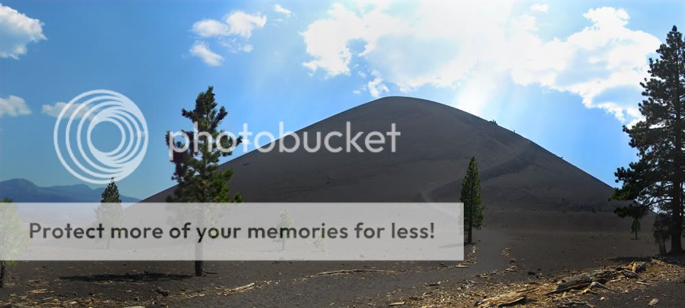
Cinder Cone is a 700 foot-high volcanic cone. There has been
controversy over its age since the 1870's, when many people thought
it was only a few decades old. Later, it was thought the cone and
associated lava flows were formed about A.D. 1700 or during a
series of eruptions lasting 300 years, ending in 1851. However,
recent studies by U.S. Geological Survey (USGS) scientists, working
in cooperation with the National Park Service to better understand
volcano hazards in the Lassen area, have firmly established that
Cinder Cone was formed in eruptions about 1650.
Cinder Cone is a small volcanic mountain formed when rock or
mineral fragments (pyroclasts) accumulate and are ejected during
explosive volcanic eruptions. Cinder cones, which are steep-sided
mountains that are often symmetrical, are what most people expect a
volcano should look like. These distinctive cone-shaped landforms
appear in many areas of the world.
The rock pieces, or cinders, that form cinder cones are mostly
fragments of basalt, a dark-colored rock. The cinders are ejected
into the air by the force of volcanic gases during an eruption. The
cinders fall and pile up into a cone shape around the volcano. A
cinder cone is relatively small because the accumulation of loose
cinders creates an unstable pile of debris, and is prone to
collapse under its own weight. Usually not more than 1600 feet
high, cinder cones are much smaller than the other general types of
volcanoes, stratovolcanoes and shield volcanoes, which can be up to
10,000 feet high. Stratovolcanoes and shield volcanoes usually
erupt over longer periods and not as explosively as cinder cones.
This allows the lava flows to accumulate in layers and create
larger, more stable volcanoes over time. Most cinder cones are
considered monogenetic volcanoes, which mean they erupt only once
for a short period and then become extinct. These eruptions usually
don’t last for more than several decades. On the other hand,
shield volcanoes and stratovolcanoes are considered polygenetic
volcanoes, because they can erupt over hundreds of thousands of
years, with inactive periods called dormancy separating the
eruptions.
To get credit please e-mail me the answers to the first three
questions, please do not post them, and post or e-mail your
picture.
#1 At coordinate N40° 33.824 W121° 18.145 What is the Pioneers
name?
#2 At coordinate N40° 33.716 W121° 18.324 What was formed as the
lava cooled?
#3 What is at coordinate N40° 33.148 W121° 19.145
#4 E-mail me or post a picture of you or your party, with Cinder
Cone in the back ground.
Would love to also see a picture of you at top if possible! If you
can make it we highly recommend it and is well worth the
journey!
For more info see USGS Site @
http://pubs.usgs.gov/fs/2000/fs023-00/
and
http://www.nps.gov/lavo/planyourvisit/upload/park_map_with_volcanic_structures.pdf
Psalm 19:1
The heavens declare the glory of God; And the firmament shows His
handiwork.
Rooks
Additional Hints
(No hints available.)