CZ: POZOR!!! Pozorne ctete cely listing jeste pred tim, nez vyrazite do terenu!
EN: ATTENTION!!! Carefully read the entire listing before they leave before you go into the field!
CESKY:
Neprehlednutelnou dominantou mesta Chrast je bezesporu vodarenská vez (vezovy vodojem) z roku 1930. Ale jeste nez vyrazite na lov teto Multi-cache, nejprve si prectete neco malo historie, bude se vam to naramne hodit ...
 Pocatky vodovodu v Chrasti se datuji do roku 1883, kdy byl vyvrtan prvni artezsky vrt (studna) a postupne i postaveny: akumulacni nadrz, dvoukomorovy zemni vodojem a rozvodna sit. V roce 1908 bylo nutne vyvrtat vrt novy, ponevadz vydatnost puvodniho pri stalem cerpani klesala. V prosinci roku 1925 zpracovava a v kvetnu roku 1926 predklada Ing. Vladimir Chmelik z Prahy technickou zpravu o stavu vodovodu ve meste Chrast, kde vyslovne doporucuje obnovu celeho vodovodu, vcetne vystavby noveho vodojemu. V letech 1929-1930 je postaven novy vodovod vcetne nove vodarny a jeste dnes slouziciho vezoveho vodojemu.
V padesatych letech 20.stoleti byly podel toku Zejbra vyhodnoceny k vyuziti rozsahle zdroje kvalitni podzemni pitne vody. Postupne zde bylo zrizeno 11 vrtu, z sesti vrtu vodarensky vyuzivanych je voda precerpavana do akumulace hlavni cerpaci stanice Podlazice. Odtud je podzemni voda prevadena do skupinoveho vodovodu Chrudim - Pardubice a po dobudovani upravny vod Monaco (Slatinany) misena s upravenou vodou povrchovou.
 Navstevnici Chrasti, kteri se zajimaji o vodni stavby, mohou zhlednout barokni stavbu vodarenske veze v casti mesta zvane Chrasice. Stavajici podoba je z r. 1746. Dominantou mesta je vsak stale funkcni vezovy vodojem, dokonceny v r. 1930.
Stara vodarenska vez v Chrasti - Chrasicich z roku 1662, opravena biskupem Janem Josefem Vratislavem z Mitrovic r. 1746. Vodarenska vez zasobovala vodou zamek a kasnu na namesti. Dnes je tato historicka stavba v majetku mesta a nepristupna verejnosti, pripravena k oprave.
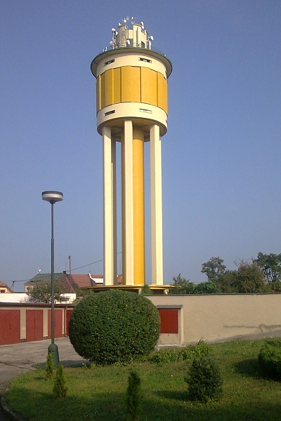
Zelezobetonovy vezovy vodojem v Chrasti u Chrudimi byl postaven v roce 1930. Konstrukci tvori v urovni 1. NP podnoz s rozsirenou plochou strechou. Strecha je nesena zelezobetonovymi sloupy. Stenami podnoze prochazi 6 ctvercovych nosnych sloupu o vysce 27,5 metru a prurezu 1x1 metr, ktere vedou az pod konstrukci vlastni nadrze. Celou stavbou prochazi zelezobetonovy tubus se schodistem vedoucim do urovne podlazi nad vodojemem. V podlazi nad vodojemem je vystup na plochou strechu. Tento vodojem prosel v roce 2008 rekonstrukci plaste, naklady na opravu se vysplhaly pres 4 mil. Kc.
Pro zajimavost pridavam parametry „Zelezobetonoveho vezoveho vodojemu “:
Interestingly adding parameters reinforced concrete water reservoir:
|
celkova vyska / total height
|
48 m
|
|
vyska strechy vodojemu / reservoir roof height
|
42 m
|
|
vyska ctvercovych nohou / square pillar height
|
27,5 m
|
|
objem nadrze / tank volume
|
200 m3
|
A nyni konecne k lovu kese!!!
Doporucuji pozorne cist zadani - dulezite informace pro slozeni souradnic finalky!!!
Vychozi souradnice - Vodojem Chrast:
N 49° 54.174' E 015° 56.203'
vas zavedou k soucasne dominante - funkcnimu vodojemu. Jedete-li „geovozidlem“, doporucuji vyuzit Parking 1, je hned vedle, a alespon nebudete parkovat v neprehledne zatacce!
Stojite-li pred vchodem k vodojemu, vsimete si pametni desky nad vchodovymi dvermi - pocet slov v prvnim (hornim) radku vám da cislo A (pokud nerozlustite slova na pametni desce, stejnou cislici vam da pocet sroubu, kterymi je pripevnena leva tabulka na brance; pocet modrych pismen na prave tabulce branky vam da cislo B.
Zastavení 2 - vodojem Chrasice:
N 49° 54.172' E 015° 56.787'
Pokud jste vozem, doporucuji prejet na Parking 2, Krcma U Jonase se po odloveni teto kesky muze stat mistem chutného obcerstveni, pripadne vychozim bodem pro odloveni pomerne nedaleke, a velmi povedene kese GC1WEAA , kterou vytvoril jemnostpan.hugo (mimochodem jeho chaloupku budete mijet cestou na finalku). Take si dovoluji upozornit, ze okolim Chrasic (mimo jine) prochazi asi nejobsahlejsi Multicache v sirokem okoli GC1PY13 ktero pro nás vytvorili monro
Na souradnicich Vodojem Chrasice: Prohlednete si odsud stary vodojem - pocet otevrenych (nezazdenych) oken na vychodni stene vodojemu vam da cislo C, pote se otocte doprava (zhruba na sever) a popojdete nekolik metru (po ceste dolu); po pravici stoji zdeny plot (plot neotloukejte, nebo vam jemnostpan.hugo natluce budku) - pocet plotovych poli (nikoliv sloupu) od waypointu az po garaz (proste ta prava, delsi cast plotu) vam da cislo D.
E = objem nadrze vodojemu
F = celkova vyska vodojemu
G = rok vyvrtani prvniho artezskeho vrtu v Chrasti
H = rok vystavby noveho zelzobetonového vodojemu
Souradnice pro finalku jsou nasledujici:
N 49° 54.(E/100)(B-C)(B/A)'
E 015° 56.(D)(B-A)[( F+H-G+A)/11]'
Na finalce se otocte smerem k rybniku - uvidite oba vodojemy soucasne a muzete se pokochat i pohledem na strechu Kostela sv.Martina na hrbitove. A nyni zbyva jen odlov kese - zalogovat, provest nejaky ten "TRADE", a trada - muzete pokracovat treba v dalsim geohledani ;-)
ENGLISH:
Water supply in Chrasti beginnings date back to 1883, when the first artesian drill hole (well), and gradually built as: storage tank, a dual-reservoir in preparation grid. In 1908 it was necessary to drill a new hole, because he yield this originally drawn under constant decreased. In December of 1925 to process and in May 1926 is presenting Ing. Vladimir Chmelik from Prague technical report on the status of water supply in city Chrast, which explicitly recommends renewal of the whole water supply system, including construction of a new reservoir. In 1929-1930 it built a new water supply, including new water towers and still today serving tower reservoir.
In the fifties of the 20th century along the river were evaluated Zejbro to utilize the vast underground sources of drinking-quality water. Gradually it was established 11 bore. Of the six Waterworks used borehole water pumped into the accumulation of major pumping stations Podlazice. From there the underground water is transferred to the group tap Chrudim - Pardubice after completion of water treatment plants Monaco (Slatinany) mixing with modified surface water.
Visitors to Chrast who are interested in water supply works, can see the baroque building of the water tower in the town district Chrasice. The current version is from the 1746th. The dominant city is still functional reservoir tower, completed in 1930.
Old water tower in Chrast - Chrasice of 1662, corrected by Bishop John Joseph Vratislav from Mitrovic in 1746th. Water tower supplies water chateau and a fountain in the square. Today, this historical building owned by the city and closed to the public, ready to repair.
Reinforced concrete water reservoir in Chrasti was built in 1930. Structure forms the ground floor at the level of stool with extended flat roof. The roof is carried by reinforced concrete columns. Walls rootstock passes 6 square pillar supporting an altitude of 27.5 meters and the cross-section 1x1 meter, resulting from the construction of own tank. The site passes the tube reinforced concrete staircase to the level of floors above the reservoir. The floor above the reservoir is output on the flat roof. The reservoir passed in 2008 reconstruction of the surface, cost of repairs is over 4 million CZK.
And now finally to hunt cache:
I recommend carefully read the entries - important information for the composition of the final coordinates!!!
Starting coordinates - Water tower Chrast:
N 49° 54.174' E 015° 56.203'
will take you to the current dominant - functional reservoir. If you drive geocar, we recommend using Parking, which is nearby, do not park in a blind curve!
If you stand in front of the entrance to the reservoir, noting plaques at the entrance door - the number of words in the first (upper) row gives the number A (if not read the words on the plaque, the same digit is equal to the number of screws, which is left attached table the gate, the number of blue letters at the right table (the gate) will give you the number of B.
Stage 2 - reservoir Chrasice:
N 49 ° 54.172 'E 015 ° 56.787'
If you drive the car, I suggest go to Parking 2 "Krcma U Jonase" caught after this cache can become a place of excellent refreshments and a starting point for quite caught nearby, and very nimble cache GC1WEAA by jemnostpan.hugo created (by the way the hut you will pass through the Finall stage). Please note also that the environment Chrasic (among others) passes around the most comprehensive Multicache afield GC1PY13 created for us monro.
The coordinates "Reservoir Chrasice": You see here an old water reservoir - the number of open windows on the east side water tower will give you a number C, then turns right (approximately north) and I go over a few meters (the way down), the right is a brick fence - number of field fence (not the column) from waypoint to garage (simply the right, a longer part of the fence) will give you the number D.
E = tank volume reservoir
F = total height of reservoir
G = year of drilling the first artesian well in Chrasti
H = year of construction of new reinforced concrete reservoir
Coordinates for the final stage are as follows:
N 49° 54.(E/100)(B-C)(B/A)'
E 015° 56.(D)(B-A)[( F+H-G+A)/11]'
At the final stage, the turn toward the pond - you will see two reservoirs at the same time and you can see the roof of the Church of St. Martin in the cemetery. And now it remains to be hunting the cache - login, make any one "trade", and then you can continue must be in the hunt next caches ;-)...
************************************************** ************************************************** **************************************************
/CZ/
Doufam, ze vam tato kes trochu rozsirila obzory znalosti, a pokud vas nezaujala, doufam, ze se vam alespon libi okoli finalky - nejkrasneji je tady na podzim!
Upozorneni pro odlov: hemzi se to tu "mudlorybari", tak pozor - budte nenapadni - fotografujte, a vubec napodobujte vselijake nenapadne cinnosti!!!
MALA NAPOVEDA: Neprsi na ni, a presto je pod ni spousta vody - skryva ji prazec, a presto neni na kolejich!
/EN/
I hope this little cache broadening the horizons of knowledge, and if you did not, I hope that you at least likes surroundings final stage - the most beautiful autumn is here!
Notice for hunting: here is a lot muglle-fishermen, so be careful - be think - shoot, and think of all sorts at all imitators activity!
LITLLE HELP: Hidden from the rain, and yet it is under a lot of water - it hides a sleeper, but not on rails!
Zdroje:
* Oficiální stránky mesta Chrast
* originální dokumenty ve vlastnictví VAK Chrudim a.s.