Ukoly zkracene bez ceske diakritiky:
1. Navstivit uvodni souradnice vedle Josefovy stoly a na dukaz Vasi navstevy zde v okoli poridit fotku (pred plotem nebo za plotem, uvnitr stoly, jak budete chtit). Dulezite je, aby bylo mozne z fotky poznat, ze jste tam opravdu byli. Tuto fotografii pripojte k Vasemu logu, ovsem pozor, at fotkou neprozradite spravne odpovedi!
2. Poslat nam pres profil spravne odpovedi (ktere zjistite viz. hint):
a) Kolik bylo provedeno jadrovych vrtu pouze z povrchu a o jake celkove metrazi?
b) Jaka byla hodnota zlata v geologickych zasobach reviru pocatkem roku 1999 v Kc? (spravna odpoved je v miliardach korun)
c) Jaka je priblizna aktualni celkova hodnota zlata v Kc v geologickych zasobach reviru dnes? (spravna odpoved je v miliardach korun)
d) Jaky je prumerny obsah zlata v gramech na 1 tunu horniny v oblasti Psich hor?
e) (Nepovinna odpoved, kterou ale zjistite vyjimecnost tohoto mista) Jaky je prumerny obsah zlata v gramech na 1 tunu horniny v zemske kure?

Pokud se Vám nechce císt dlouhý listing, mužete se kouknout na nekteré zajímavé video se základními informacemi o tomto míste Štola Josef v CT, nebo se kouknout, jak to ve štole a jejím těsném okolí vypadá, abyste vedeli do ceho jdete Webcamery.
Úvodní souradnice této earthcache Vás dovedou k ústí Josefovy štoly, kde v letech 1980 - 1990 probíhal rozsáhlý geologický pruzkum, na kterém se aktivne v letech 1987 a 1988 podílel i muj táta a pochází z nich nekteré fotografie. Výsledkem pruzkumu bylo zhodnocení zásob zlata v rudním revíru Psí hory, nacházející se v prostoru mezi obcemi Smilovice, Celina a Prostrední Lhota – cca 5 km2 na dosud známých ložiskách Celina, Mokrsko-východ (v minulosti již težených) a predevším objevení nového ložiska Mokrsko-západ, jehož využitelné zásoby byly odhadnuty na 75t zlata. Celkový potenciál ložisek revíru Psí hory (nekde se lze setkat i s oznacením Lodické hory podle tehdy existujícího dolu Lodice) byl odhadnut na 130t zlata, což je více, než kolik se vytežilo na celém území Ceské republiky behem celé historie dobývání zlata. Odborný výpocet uvádí, že u nás za celou historickou etapu težby zlata bylo získáno zhruba 100t zlata. Z toho v rýžovištích kolem 50-60t a o neco menší množství hornickým zpusobem. Zdroje zlata revíru Psí hory podle mezinárodního hodnocení v roce 1997 zaujímaly 4. místo v žebrícku velikosti evropských ložisek zlata.

TATA U STOLY JOSEF 1987
Ražba pruzkumné štoly zacala roku 1981. Má charakter úvodního prekopu a prochází SSV smerem napríc horninovým masivem Veselého vrchu (488,9 m.n.m.) až do jeho severní cásti. Odtud byla systémem podzemních chodeb a vrtu prozkoumána ložiska Mokrsko-západ i Mokrsko-východ a u ústí štoly také ložisko Celina. Délka hlavní páterní štoly, která vede napríc všemi ložisky, je 1 835m, prícný prurez má velikost 14 až 16m2. Ze vstupních portálu jsou soubežne vedeny dva tunely délky 80m o prurezu 40m2. Délka postranních chodeb na jednotlivých ložiscích je 6 018m – profil 9m2. Celková délka všech chodeb je úctyhodných 7 853m a prevážná vetšina (kolem 90%) výlomu není vystrojena. Výška nadloží je 90 – 110m. K ražbe páterní štoly byla použita ostrá skalní trhavina PERMONEX V19 a pro prumerný 2-2,5m postup vpred pro jednu 8 hodinovou smenu bylo zapotrebí navrtání 40 der a do každé se ukládal 1kg trhaviny. Tatáž smena musela odstrelenou horninu ješte odbagrovat. Pracovalo se na 3 smeny, tzn., že denní postup vpred byl okolo 6 m. Soucástí podrobného pruzkumu, který probíhal v letech 1980 - 1990, bylo geologické mapování, geofyzikální pruzkum, podrobný geochemický pruzkum pudního pokryvu, pruzkum pomocí vrtu z povrchu až do hloubky 300 – 600 m o celkové délce 23 387m a konecne bánský pruzkum z nove ražené štoly Josef, kombinovaný se 127 podzemními jádrovými vrty o celkové délce 13 137m. Tyto pruzkumné jádrové vrty (horizontální i šikmé) se provádely v délce 60-120m. Zacalo se nejprve diamantovou korunkou s vnejším prumerem 46mm (prumer získaného vzorku 32mm). Po nekolika vrtech se zjistilo, že pro rozbor jsou zapotrebí minimálne 2kg vzorku z 1m (což na tomto prumeru dosaženo nebylo), prešlo se tedy na vnejší prumer korunky 59mm (prumer získaného vzorku 47mm) (viz. fotografie GEOLOGICKÝ VZOREK –, který pochází z této oblasti a mám jej dodnes doma na památku). Délka geologických vzorku za jednu 8 hodinovou smenu se bežne pohybovala od 12m do 15m, pokud se vyskytly komplikace (hornina se štípala apod.), tak treba jen 2m za celou smenu. Celkem bylo odebráno a zanalyzováno 9 818 pudních vzorku a pres 25 000 vzorku z vrtu a z podzemí.
GEOLOGICKY VZOREK Z TÉTO OBLASTI
V letech 1989 - 1991 zde probíhala také experimentální podzemní težba ložiska Celina. Bylo vyteženo celkem 19 500t rudniny, která se zpracovávala na úpravne Rudních dolu v Príbrami. Získáno z ní bylo 21,5kg zlata.
Pruzkum, který zde byl prováden, byl zastaven z duvodu ukoncení zájmu státu zacátkem 90. let minulého století a štola i její okolí postupne chátraly. V r. 2000 byl stav areálu již natolik neuspokojivý, že bylo z bezpecnostních duvodu pristoupeno k zabetonování obou prístupových portálu do štoly.

STOLA JOSEF 2006
Dnes je štola - Podzemní výukové stredisko UEF JOSEF využívaná Stavební fakultou CVUT sloužící zejména k výuce studentu. Opravdu mnoho zajímavých informací o minulosti i soucasnosti Josefovy štoly, nebo treba zjištení informací o prohlídce útrob štoly najdete na www.uef-josef.eu.
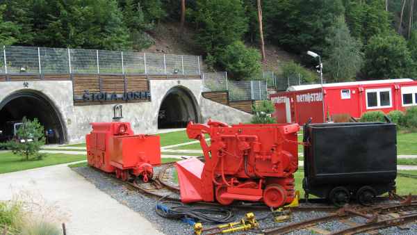
STOLA JOSEF 2009
Na pravé strane od ústí štoly jsou zbytky deponií hlušiny a rudy vytežené pri ražbe prekopu a smerných chodeb. Není to však pouze hlušina - za minulého režimu zde byla zároven provádena tzv. težba na skládku a pri troše štestí lze na odvale nalézt drobné zlatinky (použití dobré lupy je však nezbytnost). Dále je tu možné nalézt všechny typy hornin, které se podílejí na geologické stavbe revíru (bazické i kyselé vulkanity a jejich tufy, kontaktne premenené horniny - rohovce, granitické horniny). Hojné jsou i vzorky kremenné žiloviny, místy obsahující pyrit nebo arzenopyrit, pri troše štestí a trpelivosti je možné nalézt i belošedá zrna scheelitu a lupénkovitý molybdenit.
Zlato zde v Psích horách má ryzost 22-23 karátu a jako vedlejší prímes obsahuje 5% stríbra. Vetšinou tvorí velmi malé cástecky zarostlé v kremeni v sulfidech nebo i v dalších minerálech velikosti nekolika mikronu až desítek mikronu. Prumerný obsah zlata v hornine je 2 g/t. Protože však je zlato víceméne rovnomerne rozptýleno ve velkém objemu horniny v nepatrných cásteckách, bylo by nutné k jeho získání použít povrchovou težbu. To znamená jámový lom o rozmerech 400 x 600 metru a hloubce 200 metru v prostoru vrchu Veselý (premenení kopce na díru v zemi), težbu zhruba 50 miliónu tun horniny (z toho asi 30 miliónu tun by bylo rozemleto na jemnost pudru). Pro separaci zlata by navíc bylo nutné použít ekologicky riskantní metodu kyanidového loužení. Pro zdejší kraj by težba zanechala trvalou jizvu v podobe lomu, odvalu hlušiny a odkališt rozemleté rudy.

JA (UPLNE VLEVO) U STOLY JOSEF 1987
Kešku logujte rovnou „found-it“. Pokud by se vyskytly nejaké nejasnosti v odpovedích nebo v priložené fotografii, budeme Vás kontaktovat pro sjednání nápravy.
Pro uznání logu je zapotrebí splnit následující úkoly:
1. Navštívit úvodní souradnice vedle Josefovy štoly a na dukaz Vaší návštevy zde v okolí porídit fotku (pred plotem nebo za plotem, uvnitr stoly, jak budete chtit). Duležité je, aby bylo možné z fotky poznat, že jste tam opravdu byli. Tuto fotografii pripojte k Vašemu logu, ovšem pozor, at fotkou neprozradíte správné odpovedi!
2. Poslat nám pres profil správné odpovedi (které zjistíte viz. hint):
a) Kolik bylo provedeno jádrových vrtu pouze z povrchu a o jaké celkové metráži?
b) Jaká byla hodnota zlata v geologických zásobách revíru pocátkem roku 1999 v Kc? (správná odpověď je v miliardách korun) Nic nepocítejte - odpoved se nachází na stejné infoceduli jako odpoved na otázku a)
c) Jaká je přibližná aktualní celková hodnota zlata v Kč v geologických zásobách reviru dnes? (správná odpověď je v miliardách korun)
d) Jaký je prumerný obsah zlata v gramech na 1 tunu horniny v oblasti Psích hor?
e) (Nepovinna odpoved, kterou ale zjistíte vyjimecnost tohoto místa) Jaký je prumerný obsah zlata v gramech na 1 tunu horniny v zemské kure?
Kdo úspešne zaloguje found-it a bude mít zájem o zalogování „discovered“ i našeho honza-pavla´s EarthCache Geocoin, necht nám dá vedet a my mu pošleme tracking number.


Initial coordinates of this earthcache will lead you to the mouth of Josefova štola (Josef‘s Adit) where from 1980 till 1990 an extensive geological exploration was being carried out, in which also my father actively participated in 1987 and 1988. Some photographs originate from those years. The exploration resulted in evaluation of golden reserves in Psí hory (the Dog Mountains) ore territory, which is situated in the area among Smilovice, Celina and Prostrední Lhota municipalities – ca 5 km2 in deposits of Celina, Mokrsko-východ (Morksko-East) known up to the present time (already mined in the past) and first of all strike of the new deposit of Mokrsko-západ (Morksko-West), whose exploitable reserves were estimated at 75 tons of gold. The total potential of the deposits in Psí hory territory (somewhere we can also find the name of Lodické hory (Lodické Mountains derived from then existing Lodice mine) was estimated at 130 tons of gold, which is more than how much it was mined in the whole area of the Czech Republic during the whole history of gold extraction. Technical calculation quotes that in our country there was acquired about 100 tons of gold during the whole historic period of gold mining. From this about 50 – 60 tons in gold-bearing deposits and a little less amount in a mining way. Golden resources of Psí hory territory ranked fourth in the ranking of mass of European golden deposits according to international rating in 1997.
Driving an exploratory adit started in 1981. It has an initial drift nature and runs in the NNE direction through the rock massif of Veselý vrch (488.9 m above sea level) all the way to its northern part. From this point there were the deposits of both Mokrsko-západ and Mokrsko-východ and by the mouth of the adit also the deposit of Celina explored by means of a system of underground tunnels and wells. The length of the main backbone adit, which runs through all the deposits, is 1,835 m, the transverse section is from 14 up to 16 m2. There are two 80 m long tunnels, having 40 m2 in section, running collaterally from entry portals. The length of side tunnels at individual deposits is 6,018 m – the profile is 9 m2. Total length of all the tunnels is considerable 7,853 m and vast majority (around 90%) of breaks is not reinforced. The height of the roof stone is from 90 to 110 m. PERMONEX V19 live rock explosive was used for driving the backbone adit and drilling about 40 holes and putting 1 kg of explosive in each of them were necessary for an average 2 up to 2.5 m long progress for one 8-hour shift. The same relay still had to dig off the blasted rock. There were 3 shifts a day, so the daily progress ahead was around 6 m. A part of an in-depth exploration which was under way from 1980 till 1990 was geological mapping, geophysical exploration, in-depth geochemical exploration of soil overlay, exploration by means of wells from the surface up to the depth of 300 to 600 m in the total length of 23,387 m and finally mining exploration from the newly dug adit of Josef combined with 127 underground core wells in the total length of 13,137 m. These exploratory core wells (both horizontal and skew) were carried out in the length of 60 to 120 m. First they started with a 46 mm external diameter diamond bit (the diameter of an extracted sample was 32 mm). After a few wells they found that there were at least 2 kg of samples from 1 m necessary for analysis (which wasn’t reached at this diameter), thus they went over to a 59 mm external diameter diamond bit (the diameter of an extracted sample was 47 mm) (see the photo GEOLOGICAL SAMPLE – the bigger one comes from this area and I still keep it at home as a souvenir). The length of geological samples per one eight-hour shift usually ranged from 12 m to 15 m, if complications occurred (the rock was breaking and suchlike), then possibly only 2 m per the whole shift. On the whole there were 9,818 soil samples and more than 25,000 samples from wells and from the underground taken and analysed.
Also, an experimental underground mining of the deposit of Celina took place here from 1989 to 1991. On the whole 19,500 tons of ore, which was processed in an ore mill in Rudné doly (Ore Mines) in Príbram, were extracted. 21.5 kg of gold were extracted.
The exploration which was being carried out here was stopped from the reason of termination of interest of the state at the beginning of 90s of the last century and the adit and its surroundings were gradually decaying. The condition of this area was already so unsatisfactory in 2000 that both entry portals to the adit were concreted from safety reasons (see the photo JOSEF‘S ADIT 2006).
The adit (UEF Josef – Underground Educational Centre JOSEF) is used by Stavební fakulta CVUT (Faculty of Civil Engineering of CTU see the photo JOSEF‘S ADIT 2009) these days and it serves the teaching of students in particular, see details at www.uef-josef.eu where it is also possible to order a tour of the adit.
On the right side of the mouth of the adit there are remainders of dumping sites for waste rock and ore which was extracted during driving drifts and guiding tunnels. However, that is not only waste rock – there was so called mining to dump concurrently carried out during the former regime and it is possible to find tiny golden pieces on the waste pile with a bit of luck (however, to use a good magnifying glass is necessary). Then it is possible to find here all the types of rock which participate in the geological structure of the territory (alkalic and acidic vulcanite and its tuffs, contactly changed rock – hornstones, granitic rock). Samples of silica gangue, which contains pyrite or arsenopyrite in patches, are plentiful. It is possible to find also white grey grains of scheelite and laminal molybdenite with a bit of luck and patience.
The gold here, in Psí hory (the Dog Mountains), is of 22 to 23 carat purity. It contains 5% of silver as side admixture. It mostly creates very small particles rooted in silica in sulphides or even in other minerals. Their size is of a few microns up to a few ten microns. The average content of gold in the rock is 2 g/t. Because of more or less even dispersal of the gold in a large amount of the rock in tiny particles, it would be necessary to use surface mining for its extraction. That means a pit of size 400 x 600 metres and of depth 200 metres in the area of the hill of Veselý (transformation of a hill into a hole in the ground), mining about 50 million tons of rock (from that about 30 million tons would be ground to the fineness of powder). Furthermore, it would be necessary to use the ecologically risky method of cyanide lixiviation to separate the gold. The mining would leave this region with an everlasting scar in the form of the pit, waste piles of waste rock and settlement tanks of ground ore.
Log the cache directly as „found-it“. If any unclearness in answers or in the enclosed photograph occur, we will contact you to fix it.
In order to recognize the log, it is necessary to carry out the following tasks:
1. To visit initial coordinates near Josef’s Adit and to take a photo in the surrounding. The photo should show that you really visited the place. Attach this photograph to your log but pay attention not to tell right answers by the foto!
2. To send us correct answers to the following questions, which you find see hint, through our profile:
a) How many underground core wells was carried out only from the surface and in which total length?
b) What was value of gold in geological reserves of territory in the beginning of the year 1999 in czech crowns?
c) What is approximate value of gold in czech crowns in geological reserves of territory today? (calculation at home)
d) What is the average content of gold in grams per 1 ton of rock in the area of Psí hory (the Dog Mountains)?
e) (Optional response) What is the average content of gold in grams per 1 ton of rock in Earth’s crust?
Aktuální cena zlata v USD (americký dolar) za unci + vývoj ceny zlata za rok