Close to the stop-sign at the designated coordinates is a big
road-sign pointing directly at a very unique mountain, 6 km away,
towering some 800m above your present location. (Its name is
included as part of one of the locations on this sign – see
question 1 below.)
It does not take much imagination to notice that this mountain
looks distinctly different from all of the others around it. It is
totally overgrown with thick vegetation right to its summit,
compared to the others which are rocky and has thin poor soils,
hence barren. Most noticeable is its colour, from which this green
mountain’s name is derived. (Note: This is best seen in the
afternoon with the Sun behind you, so if possible, plan your trip
for afternoons.)
So, why does this mountain look so different to its neighbours?
Could it be that it formed differently to the mountains around it?
A fairly common belief amongst locals around Wellington it is of
volcanic origin, hence its odd appearance. Others will tell you it
is because it is covered with a distinctly different soil type. But
how did this happen?
To answer this we need to look at the local geology, best
illustrated by the picture below, adapted from the research of
Keith Mackenzie, available from the Wellington museum. (The bulk of
this text is based on Keith’s research, supplemented by input from
prof. John S. Compton of the University of Cape Town.)
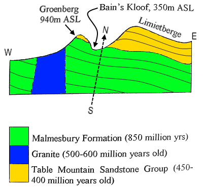
Referring to the figure above which shows an east-west slice
through your present location, the geology of Wellington comprises
two geological formations: the underlying Malmesbury Formation
(green), overlaid by the Table Mountain Sandstone Group (yellow).
The former comprises shale, mudstone and other soft rock-types
which erode and decompose relatively easily, compared to the harder
sandstones which break down much slower. It is this hard layer
capping the present mountains that prevented them from eroding down
to the level of where you are standing now.
The topography was affected by a fault which caused the rock
strata to tilt, as shown in the figure above. This fault lies on a
north-south axis between the mountain in front of you and the
Limiet range behind it (the dotted line in the sketch above). If
you look carefully, you can see evidence of the few remaining
fragments of Table Mountain Sandstone close to the summit,
overlaying the Malmesbury Formation. This same contact surface lies
gradually lower as you travel east through Bain's Kloof, reaching
the level of road - only about 340 m above seal level (ASL) - by
the time you exit Bain’s Kloof on the Ceres/Worcester side. The
fault line is virtually parallel to the Bain’s Kloof road.
The mound in front of you thus composes mainly of decomposed
Malmesbury shale which weathers to a rich soil, ideal for
vegetation to grow in. In comparison, the background mountains are
overlaid with extremely hard Peninsula Formation Sandstone whose
quartz-rich rocks give only thin poor soils. The only igneous rock
nearby is the Cape Granite which is an intrusive igneous rock and
not volcanic.
To claim “Found it” you must email me satisfactory responses to
the following:
Any logs not accompanied by an email will be deleted.
- Take a picture of you/your party with your navigation device at
the road-sign, pointing out the name of the mountain in the
sign.
- From a convenient position close to the designated coordinates,
take a picture of this mountain and include part of a neighbouring
one, showing the contrast (ideally done in the afternoon).
- What makes it possible for vegetation to grow all the way to
the summit of this mountain?
- Is the local belief that the origin of this mountain is
volcanic true or false?
Note: Do not post your pictures,
replies or hints to this page, even if
encrypted.