Krkonosská tundra EarthCache
-
Difficulty:
-

-
Terrain:
-

Size:  (not chosen)
Please note Use of geocaching.com services is subject to the terms and conditions
in our disclaimer.
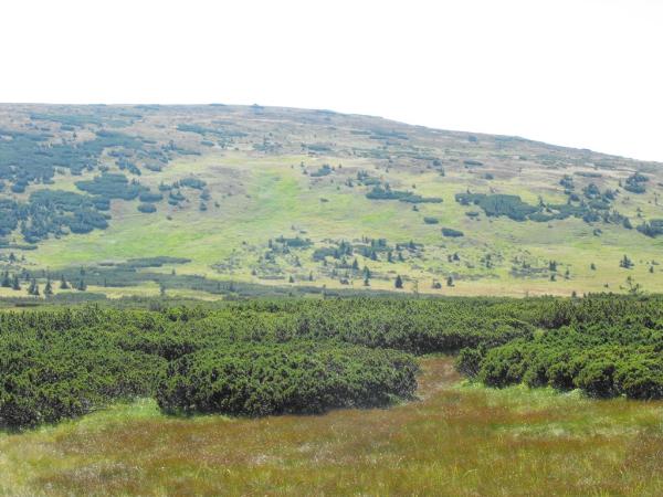
Krkonosská tundra occupies a mere 4.4% NP area (ie around 1600 ha),
but there is a unique environment of European importance, very
sensitive to anthropogenic influences.
Is solved as a whole because it constitutes an indivisible mosaic
of forest (cage stands) and non-forest habitat above the upper
limit of forest and glacial karech.
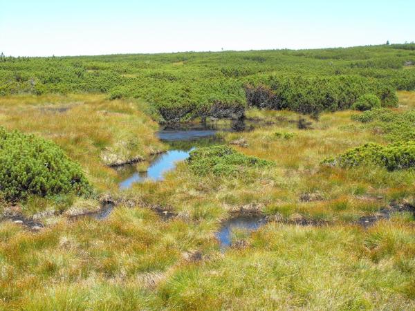 Nature Reserve (since 1952) Upsky Peat (72.8 ha) is located in a
shallow depression between Hranicni mountain about 2 km west of
Snezka in height from 1400 to 1425 meters above sea level. Protects
the largest peak bogs in Krkonose, which commemorates the subarctic
tundra, which intervene during the Ice Age here. The thickness of
peat is xxxxx to xxxxxx meters (task No. 2), there are water-filled
cracks greater peat lakes, deep almost xxxxx m (task No. 3) has
also called peat mounds Bulty. Islands of dwarf pine stands create
table form. Scrub pine that is intertwined with the Cyperus plants,
particularly grass (also called Krakonos beard), the white islands
shine far during maturation of seeds in September. The moor arose
mainly gradual dying off of plants moss, sphagnum moss (Sphagnum
sp.), Lichens, grasses and sedges, etc. already in the period
before 5000-6000 years ago.
Nature Reserve (since 1952) Upsky Peat (72.8 ha) is located in a
shallow depression between Hranicni mountain about 2 km west of
Snezka in height from 1400 to 1425 meters above sea level. Protects
the largest peak bogs in Krkonose, which commemorates the subarctic
tundra, which intervene during the Ice Age here. The thickness of
peat is xxxxx to xxxxxx meters (task No. 2), there are water-filled
cracks greater peat lakes, deep almost xxxxx m (task No. 3) has
also called peat mounds Bulty. Islands of dwarf pine stands create
table form. Scrub pine that is intertwined with the Cyperus plants,
particularly grass (also called Krakonos beard), the white islands
shine far during maturation of seeds in September. The moor arose
mainly gradual dying off of plants moss, sphagnum moss (Sphagnum
sp.), Lichens, grasses and sedges, etc. already in the period
before 5000-6000 years ago.
Many species of flora and fauna of the Ice Age (known as glacial
relicts) have kept due the harsh local climate , for example Vsivec
Sudeten (Pedicularis sudetica) Blábrystingur Sandpiper (Luscinia
svecica), punch a mountain (Aeschna coerulea). Its southernmost
extension are found coming from the north a little blackberry
cloudberry (Rubus chamaemorus), crouching in the undergrowth scrub
pine (Pinus mugo) that are intended as a kind of alpine origin,
again its most northerly position.
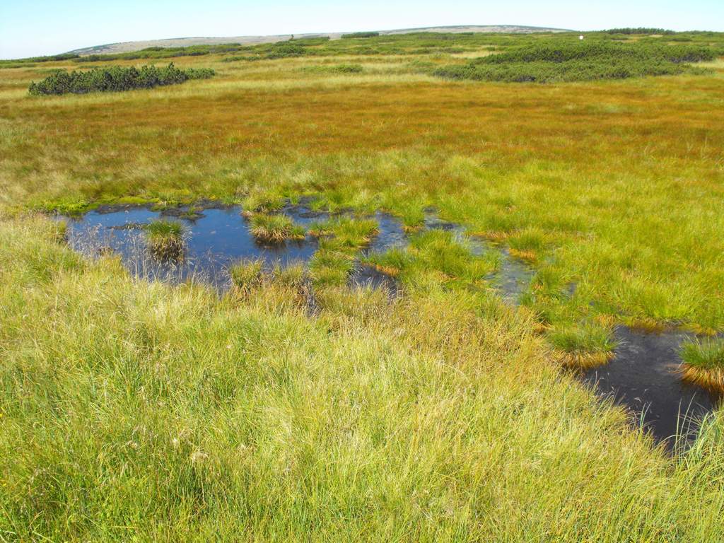
 Upa moor is one of the most valuable lots Krkonos natural and
important hydrological areas (in 1993 was included as a wetland of
international importance protected by the Ramsar convention).
Detainees in the bog waters give rise to the river UPA, (Upa creek
then over the edge of falling deeply into the giant mine) and White
Labe (flowing westward around the Meadow Kennels and Maid bridges
over Spindleruv Mlyn is the main stream flowing Elbe). Nature
reserve is now part of large NPR Sources Upa. Waterfall Upa is
divided into Upper and Lower Upa waterfall. Upper Upa waterfall
(120 m) is among the highest waterfalls in the Giant Mountains. It
lies west of Snezka near the giant mine.
Upa moor is one of the most valuable lots Krkonos natural and
important hydrological areas (in 1993 was included as a wetland of
international importance protected by the Ramsar convention).
Detainees in the bog waters give rise to the river UPA, (Upa creek
then over the edge of falling deeply into the giant mine) and White
Labe (flowing westward around the Meadow Kennels and Maid bridges
over Spindleruv Mlyn is the main stream flowing Elbe). Nature
reserve is now part of large NPR Sources Upa. Waterfall Upa is
divided into Upper and Lower Upa waterfall. Upper Upa waterfall
(120 m) is among the highest waterfalls in the Giant Mountains. It
lies west of Snezka near the giant mine.
Correction OVER BOGS water regime was not until 1996 significantly
affected by tourism, which was also badly finished xxxxxxxxx (task
No. 1). This problem was solved by restructured and replaced with
seats, increased wooden sidewalk and transversal bulkheads. Also
stally inadequate xxxxxxxx (task No. 1) was removed. Previously,
through a separate section bogs and again began to function as a
whole.
Northern part of moorland leads Route (blue) from the former Giant
Meadow shed to shed. In other parts of the peat entry is not
allowed.
International Network of Biosphere Reserves by UNESCO:
Biosphere Reserve Krkonose / Karkonosze (cross-border, Czech
Polish BR, published in 1992) Area of Conservation: EVL Krkonose
(CZ 524044, area 54.980 ha;)
Conditions of recognition of the logo: Please Stach a photo of
yourself and Krkonos moor. Please, do not leave the sidewalk!
Reply to questions and send them to the email in my profile:
The signboards are taken down during winter, the change is in
requirements of the log. Take a picture of yourselves at the
direction towards LUCNÍ BOUDA and towards SNEŽKA. Measure the above
sea level (altitude) at the opening map reference and send it to my
profile.
Krkonošská tundra
Tundrové ekosystémy

Krkonošská tundra zaujímá pouhá 4,4 % rozlohy NP (tj. zhruba 1600
ha), jedná se však o unikátní prostredí evropského významu, velmi
citlivé k antropogenním vlivum. Je rešena jako celek, protože ji
tvorí nedelitelná mozaika lesních (klecové porosty) i nelesních
biotopu nad horní hranicí lesa a v ledovcových karech.

Prírodní rezervace (od roku 1952) Úpské rašelinište (72,8 ha) se
nachází se v melké prolákline mezi Hranicním hrbetem a Studnicní
horou asi 2 km západne od Snežky, ve výšce 1400 - 1425 m n.m..
Chrání nejrozsáhlejší vrcholové rašelinište v Krkonoších, které je
pripomínkou subarktické tundry, která sem zasahovala v dobe ledové.
Mocnost rašeliny je xxxx - xxxx metru ( úkol c. 2.), Jsou tu vodou
vyplnené pukliny i vetší rašelinová jezírka, hluboká až xxxx metru
( úkol c. 3.) a také rašelinné kopecky zvané bulty. Ostruvky
klecovitých porostu vytvárejí stolové formy. Kosodrevina se tu
prolíná s porosty šáchorovitých rostlin, zejména suchopýry (zvané
také Krakonošovy vousy), jejichž bílé ostruvky v dobe zrání semen
dodaleka zárí. Rašelinište vzniklo predevším postupným odumíráním
rostlinek mechu rašeliníku (Sphagnum sp.), lišejníku, tráv a ostric
aj. již v dobe pred 5000-6000 lety.
Díky drsnému místnímu klimatu se tu uchovala rada druhu flóry a
fauny z ledové doby (tzv. glaciální relikty), napr. všivec sudetský
(Pedicularis sudetica), slavík modrácek tundrový (Luscinia
svecica), šídlo horské (Aeschna coerulea). Své nejjižnejší
rozšírení zde nalezl ze severu pocházející malý ostružiník moruška
(Rubus chamaemorus), krcící se v podrostu borovice kosodreviny
(Pinus mugo); ta zde má, jakožto druh puvodem alpský, zase své
nejsevernejší stanovište.
Úpské rašelinište je jedna z prírodovedne nejcennejších partií
Krkonoš a významnou hydrologickou oblastí ( v roce 1993 byla
zarazena mezi mokrady mezinárodního významu chráneného Ramsarskou
konvencí). Vody zadržované v rašeliništi dávají vznik rece Úpe, (ta
poté pres Úpskou hranu padá hluboko do Obrího dolu) a Bílému Labi
(tece západním smerem kolem Lucní boudy a u Dívcích lávek nad
Špindlerovým Mlýnem se stéká s hlavním tokem Labe). Prírodní
rezervace je dnes soucástí velkoplošné NPR Prameny Úpy. Úpský
vodopád se delí na Horní a Dolní Úpský vodopád. Horní Úpský vodopád
(120 m) patrí mezi nejvyšší vodopády v Krkonoších. Leží západne od
Snežky v blízkosti Obrího dolu.
REKOSTRUKCE PRES RAŠELINIŠTE Vodní režim byl však do roku 1996
významne ovlivnen turistickou cestou, která byla navíc nevhodne
povrchove upravena xxxxxxxxx ( úkol c. 1.). K náprave tohoto stavu
byla cesta rekonstruována a místy nahrazena zvýšeným povalovým
chodníkem a prícními prepážkami. Také naprosto nevhodné xxxxxxxx
bylo odstraneno. Dríve cestou oddelené cásti rašelinište tak opet
zacaly fungovat jako jeden celek.
Severní cástí rašelinište vede turistická cesta (modrá) od bývalé
Obrí boudy k Lucní boude. Do ostatních cástí rašelinište není vstup
povolen.
Mezinárodní sít biosférických rezervací UNESCO: Biosférická
rezervace Krkonoše/Karkonosze (preshranicní, cesko polská BR,
vyhlášená v roce 1992) Evropsky významná lokalita: EVL Krkonoše (CZ
524044, rozloha 54.980 ha;)
Podmínky uznání logu: Na zimu jsou tabule sundané, tudíž zmena v
podmínkách logu.
1.Vyfot te se smerem na LUCNÍ BOUDU a ješte smerem na Snežku, foto
pridejte k logu.
Zmerte na úvodních souradnicích nadmorskou výšku a pošlete me jí na
profil.
Additional Hints
(Decrypt)
Vasbezngvba obneqf vafvqr gur zrnqbj xraaryf
Vasbeznpaí gnohyr,