
BEAR TRAIL - stone beauties
Bear Trail is the oldest nature trail in Šumava (established in 1967) and as the name suggests paths, is linked to the history of shooting the last bear Sumava (November 14, 1856). The way you see the quantity of stone body with names like Skalni vyhlidka, romatische prospect Pernikova vez, Souteska lapku, Goticky portal, Kaple, Hrib, Kamenna kraska, Obri kostky and more. Come and around the beautiful Jeleni jezirko - is still on the watch. Bear path is complete in several versions..
Protection grounds: periglacial phenomens at Pernikovy vrch in Šumava.
 |
 |
Geological characteristics: Quaternary denudation of the Bohemian Massif. surroundings Pernikovy vrch (Trojmezenská hornatina), is built clear coarse-grained, isinglass stone The so-called : pleknštejn granit. Of the various forms of weathering and removal rocks here are in addition to shape emerging in recent humid fossil climate also shapes, characteristic of the area nival climate. From mezoform been large boulders prism shape with relatively sharp edges, which significantly differ from the rounded stone, resulting in the current climate prevailing chemical weathering folder. The following covers most of these slopes of mountains at high altitudes and creating soliflukcion stretched mantle rock. On slopes and tops of the mountains are preserved frost cliff and slopes, from a few meters high, beetling cliff vertical rock walls, transit at cryoplanation plattforms and terraces ( generated abolition frost cliffs ) The following released partially covered. Another development ( particularly transect ) frost cliffs here developed the rock wall, it is a few tens of meters long and often up to 10 m high rock formations, limited parallel walls significantly protruding above the surrounding terrain. Their continued widespread destruction incurred limited services, known as insulated roks. These periglacial mezoforms are often modeled in detail various microforms recents age, such as different rock niches and cavities, rock bowl, etc. In addition to described a recent periglacial forms are maintained unique remnants of older forms of weathering and ablation rocks, resulting in terciers tropical climate permanently wet rain forest, respectively. periodically dry (savannah) climate, as a cavity-type tafone and two boulders pocket rocks. As known periglacial phenomena that arise, the following continental or mountain glaciers. In this not glaciation area dominated by the harsh climatic conditions of mechanical weathering over chemical weathering. Periglacial areas of the Pleistocene was basically the entire Bohemian Massif and the Bohemian Forest in particular, where applicable also influence local glaciation, we find various speeches and weathering of rocks in removal nival climate. Fusion water that penetrated into the warmer periods fracture system in rocks, frozened here in cooling in ice. It was repeated by a compact rock gradually tearing and were characterized by different meso-and microforms relief.
Ceska geologicka sluzba
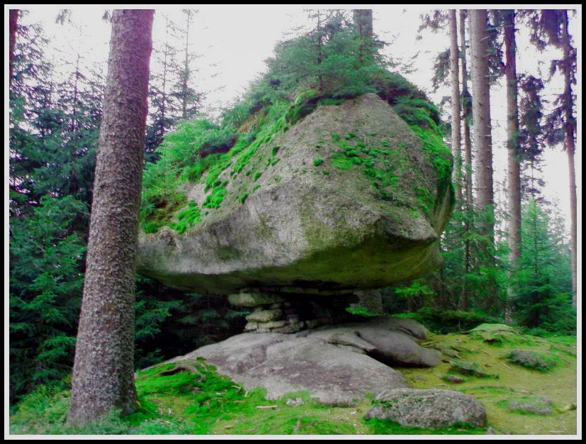
Detail of Plenkstein granite
Wiev from stone beautiful
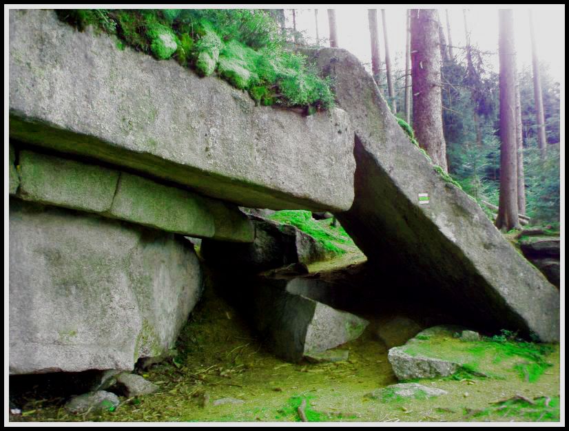
This earthcache leads you through the amazing granite rock city abridged version of the „Medvedí stezka“ (Bear trail). You can start at „Jelení Vrchy“ or away from „Ovesná“, and it will be our case. A little bit the train station Ovesna you come to the information board to learn history of „Medvedí stezka“. From there, follow the yellow marked path to further information table - OD PRVOHOR PO DNEŠEK - here are waiting for you the first two tasks. Question A you will find on this board, then you need to find the information metal table „ŽULOVÝ MASÍV PLECHÉHO“ which is installed near and here answer the question B. Path will lead you up through the roots, still following the yellow sign to the coordinates N 48° 48.649 E 013° 55.635 to the formation called „Perníková skála“ (Gingerbread rock). Here upload your photos with GPS in order for to see the oblique plate. Now you will go a little bit up to the hill through the „Souteska lapku“ around the beautiful rock formations up to the guidepost in „V Oreší“, here is the question C. On the forest way you will get to the rock gallery. There is a formation called the „Hrib“ (Mushroom) and here again take your photo with GPS according to spoiler. Here I recommend you to walk the full granite gallery, there is wonderful. The following rock formation on the coordinates N 48° 49.018 E 013° 54.667 is very interesting and therefore answer its name - the question D. From here the path a little bit drops aroud the refreshing stream and then will rise again to the „Kamenná kráska“ (Beauty of stone). From there a wonderful view of the countryside. Continue on to the coordinates N 48° 49.406 E 013° 54.345 , there is the question E- the name of the department. You start slowly to finish, rock city „Perník“ (Gingerbread) is the icing on the cake. From there the path is already sinking to „Jelení jezírko“ (Deer lake) and there is the last question F. There are already yellow sign hooks on the road on which you get into the „Jelení vrchy“ (Deer hills). I hope that this walk measuring less than 7 km you will enjoy as well as we.
Insert your photo spoiler
If you want to log this cache,you have to complete following tasks:
- 1 – How are modeled periglacial forms in the Rock city? – question A
- 2 – How is called this type of Pleknstejns granite? – question B
- 3 – Insert the photo of yourself with GPS and „Perníková skála“ (gingerbread rock)
- 4 – Guidepost in the nut grove - here find the altitude - question C
- 5 – Insert the photo of yourself with GPS with „Hrib“ according to spoiler
- 6 – How is called this formation ? – question D
- 7 – How is called this formation ? – question E
- 8 – How long paved sewer, Jeleni smyk from the outlet and connected to the channel? – question F
-
All answers send to my email krutizlab.geo@gmail.com
The logs which will not comply with the requirements will be deleted.
Don´t forget to visit site :NATURE TRAIL OF BEAR TRAIL
Map of the area BEAR TRAIL

Medvedí stezka je nejstarší naucnou stezkou na Šumave (vznikla v roce 1967) a jak napovídá název stezky, je spjatá s historií zastrelení posledního šumavského medveda (14. listopadu 1856). Cestou uvidíte množství kamenných útvaru s romatickými názvy jako Skalní vyhlídka, Perníková vež, Souteska lapku, Gotický portál, Kaple, Hrib, Viklan, Kamenná kráska a Obrí kostky a další. Pujdete i kolem krásného Jeleního jezirka - bude se porád na co dívat. Medvedí stezku lze absolvovat v nekolika variantách a smerech.
DUVOD OCHRANY: Periglaciální jevy na Perníkovém vrchu na Šumave
Geologická charakteristika: Kvartér denudacních oblastí Ceského masivu. Okolí Perníkového vrchu (Trojmezenská hornatina), je budováno svetlou hrubozrnnou, dvojslídnou tzv.pleknštejnskou žulou. Z mezoforem jsou nejrozšírenejší velké balvany hranolovitého tvaru s pomerne ostrými hranami, které se výrazne odlišují od zaoblených balvanu, vznikajících v soucasném podnebí pri prevládající chemické složce zvetrávání. Tyto hranáce pokrývají vetšinu svahu hor ve vyšších nadmorských výškách a vytvárejí soliflukcí rozvlecený zvetralinový plášt.Na svazích a vrcholech hor jsou zachovány mrazové sruby a srázy. Dalším vývojem (zejména protínáním) mrazových srubu se zde vytvorily tzv. skalní hradby, tj. nekolik desítek metru dlouhé a casto až 10 m vysoké skalní útvary, omezené rovnobežnými stenami, výrazne vycnívající nad okolní terén. Jejich pokracující destrukcí vznikly plošne omezenejší útvary, nazývané izolovanými skalami. Zde jako periglaciální oznacujeme jevy, které vznikají v predpolí kontinentálního nebo horského ledovce. V této nezalednené oblasti prevládá v drsných klimatických podmínkách mechanické zvetrávání nad zvetráváním chemickým. Periglaciální oblastí byl v pleistocénu v podstate celý Ceský masiv a zejména na Šumave, kde se uplatnoval též vliv místního zalednení, nacházíme nejruznejší projevy zvetrávání a odnosu hornin v niválním klimatu. Tavná voda, která pronikala v teplejších obdobích do puklinového systému v horninách, mrzla zde pri ochlazení v led. Jeho opakovaným pusobením byla kompaktní skála postupne trhána a vznikaly ruzné charakteristické mezo- a mikroformy reliefu.
Tato earthcache Vás provede úžasným skalním žulovým mestem zkracenou verzi Medvedí stezky. Lze zacít na Jeleních Vrších nebo smerem od Ovesné, a to bude náš prípad. Kousek od zeleznicni stanice Ovesna prijdete k informacní tabuli, kde se dozvíte histori Medvedí stezky. Odtud postupujte po žluté turistické znacce až další informacní tabuli - OD PRVOHOR PO DNEŠEK – zde Vás cekají první dva úkoly. Otázku A zjistíte na této desce, dále musíte najít poblíž instalovanou plechovou informacní tabulku ŽULOVÝ MASÍV PLECHÉHO a zde zodpovezte otázku B. Cesta Vás povede vzhuru pres koreny, stále po žluté znacce až na souradnice N 48°48.649 E013°55.635 k útvaru zvaného Perníková skála. Zde uploudujte své foto s GPS tak,aby za vámi byla videt šikmá deska. Ted Vás cesta opet trochu povede vzhuru do kopce pres Soutesku lapku kolem krásných skalních útvaru až na rozcestník V Oresi, zde je otázka C. Po lesní ceste se dostaneme ke skalní galerii. Zde je útvar zvaný Hrib a zde opet poridte svoji fotografii s GPS dle spoileru. Zde Vám doporucuji si celou tuto žulovou galerii projít, je zde nádherne. Následující skalní útvar na souradnicích N 48°49.018 E 013°54.667 je velice zajímavý a proto zodpovezte jeho název – otázka D. Odtud cesta kousek klesá kolem osvežujícího potucku, aby se zase vyšplhla nahoru až ke Kamenné krásce. Odtud je nádherný výhled do kraje. Pokracujete dále až na souradnice N 48°49.406 E013°54.345 , zde otázka E – jméno tohoto útvaru. Zacínáte pomalu finišovat, skalní mesto Perník je trešnickou na dortu. Odtud cesta již klesá až k Jelenímu jezírku a poslední otázka F. Zde se již žlutá napojuje na silnici, po které se dostanete do Jeleních Vrchu. Doufám, že se Vám tato procházka merící necelých 7 km bude líbit také tak, jako nám..
Vlozte vase foto dle spoileru
Jestlize budete chtit zalogovat tuto earthku, musite splnit nasledujici ukoly:
- 1 – Jak jsou modelovany periglacialni formy ve skalnim meste, otazka A
- 2 – Jak se nazyva tento typ Pleknstejnske zuly – otazka B
- 3 – Vlozte foto sebe s GPS a Pernikovou skalou
- 4 – Rozcestnik V Oresi – zde zjistete nadmorsku vysku – otazka C
- 5 – Vlozte foto sebe s GPS a Hribem dle spoileru
- 6 – Jak se nazyva tento utvar – otazka D
- 7 – Jak se nazyva tento utvar – otazka E
- 8 – Jak je dlouha dlazdena stoka, tzv. Jeleni smyk,od vypusti az po napojeni na kanal – otazka F
-
Odpovedi zasilejte na mail krutizlab.geo@gmail.com
Nezapomente navstivit stranku : Medvedi stezka
Mapa : MEDVEDI STEZKA