Jama Grotta Baredine Kroatien EarthCache
Jama Grotta Baredine Kroatien
-
Difficulty:
-

-
Terrain:
-
Size:  (other)
Please note Use of geocaching.com services is subject to the terms and conditions
in our disclaimer.
Jama Grotta Baredine Kroatien
Cave Baredine
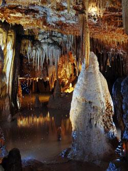
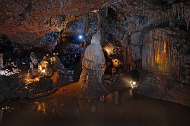
Get to know the mysterious play of nature which took thousands of years to develop, far away from daylight and the eye of man... Visit the underground world of the CAVE BAREDINE. This cave has an abundance of stalagmites and stalactites, underground sculptures created by patient and long-lasting performance of water. In this way incredible dripstones were created, the most prominent of which are the 10 meter long, high "curtains", a very realistic statue of Madonna, the body of the shepherdess Milka, the leaning tower of Pisa, the snowman - a torchbearer who became the trademark of the cave. In one of the halls you will pass by a cave 4 m wide and 66 m deep which descends to underground lakes. On your walk through the cave you will pass through 5 halls, 5 galleries of abstract and realistic sculptures, a pleasant 40-minute walk along the 300 meter long path under guidance of our tour guide and "curator". Another feature of interest of this adventure is the encounter with the underground animal world: you will see the human fish (Proteus anguinus), an endemic species that lives only here, in the karst landscape, and the miniature transparent crabs and beetles. At the entrance into the cave there is a glass case where you can see the remains of the pottery of the prehistoric man. Our distant forefather had probably, during hot and dry summers, put his pots here to be filled with water, drop for drop.
Cave Baredine is situated near the place Nova Vas, in the vicinity of the towns Porec, Visnjan and Tar. The road that leads to the cave is marked with signs, and next to the cave is a spacious parking lot for cars and buses. The cave is a protected geomorphologic natural monument. The depth of the cave is 132 meters with underground lakes whose depth sometimes reaches 30 meters. Temperature in the cave is non-varying and lies at 14°C. Next to the cave you can find an info and ticket stand, stands where you can buy postcards and souvenirs, a roofed terrace with gastronomic offer, an ethnological collection of old agricultural machinery, a gallery for photography exhibitions. For picnic lovers we have set a place with tables and benches next to the cave. For groups of school children we can organise games on the wide meadow next to the cave. You get to know mystical world of nature, which for millennia was far from natural light and the human eye ... Visit the underworld of the cave BAREDINE. This cave is a treasure chest of stalagmites and stalactites, underworld sculptures created by the patient work of water. Thus shapes have emerged, of which the 10-meter-long "curtains", a very realistic sculpture of Our Lady, "the body of the" Hirterin Milka, the Tower of Pisa and a snowman, who has become the trade mark of our cave known.

In one of the halls you go next to a 4-meter by 66 meter wide and deep chasm that stretches down to the underground lakes. In summary, looking at you through five halls, five galleries of abstract and realistic sculptures, a pleasant 40 minute walk from our leaders. The excitement of this adventure is also meeting the animals of the underworld, you are olm human fish (Proteus), an endemic species which lives only in our karst areas, miniature see-through crabs and insects. At the cave entrance is a museum showcase where pottery is on display dating from prehistoric times. Our prehistoric ancestors would probably warm and dry summers leave the pots in order to fill, drop by drop of precious water.
With Grotto BAREDINE also a love story of 13-em-century is bound. If we are to believe the legend, a nobleman named Gabriel fell from Porec in a beautiful Hirterin from the village of Nova Vas love named Milka. The old mother of Gabriel was able to cancel with no stunt, and this love has given the bandits kill three gold coins hidden around Milka too. Bandits have thrown good Hirterin into the cave. When Gabriel found out has a bad fate for his beloved, he got on his horse and disappeared. People have found later, but his horse in an obvious cave.
The tale tells that petrified corpse sad Hirterin from century to century in stages to their Promised looking slides to cave floor, where she is seeing now. Today's cavers decide that you can go digging through low to the next cave. That is, in fact, a confirmation of this legend that will meet one day the bodies of our Romeo and Juliet in the underworld and also to remain that way.
The greater part of the Istrian peninsula is composed of carbonate rocks in the more developed of caves and grottos. In the western part of Istria Carboniferous rocks are usually flattened and red soil, so-called "Terra Rosa", covered.
Particularly in this lively area, near Porec, near the village of Nova Vas, the cave was named Baredine, one of the most attractive caves of Istria. Some then discovered finds evidence that people have visited since prehistoric times this grotto. From 1973, the Grotto of members of the Association spelälogischen "Proteus has been investigated" and found underground lakes. At her suggestion, the Baredine in 1986 was published because of its specificity and richness of their ornaments for a natural monument. At the beginning of the nineties, it began actual work on reconstruction of the cave and it is open to the public since May 1995.
Developement of dolinas
The word dolina is derived from the Slovenian word for valley. As dolinas or sinkholes people name cylindrical-shaped, funnel-shaped or bowl-shaped depressions of mostly round or oval outline. They are formed by solution and washout of the rock on the surface by rainwater, which intrudes through a slit into the rock, or they form through effluent water which rinses loose material. Contrary to this the so called sinkhole is to be traced back to the fact that a hollow collapsed underground, for example because of an instable ceiling or as a result of tectonic movement. But these holes often are a hybrid of dolina and sinkhole. As vertical or diagonal funnels dolinas often lead into caves.
Your Task:
Take a picture of yourself (with GPS) on the coordinates N 45° 16.220 E 013° 39.719´, is not mandatory but would be nice of you. Thank you
1. What's the name of the Cave Climbing Centre?
2. Year of construction of the Fordson F (at museum tractor)
The museum should not be visited, the answer can be found on an information board (Baredine)
3. These red soils gave this part of the country's name?
Send the answer to: Example: you get tennisarm-2011-adria-meere@starfisch.de then immediately released.
The number of question marks correspond to the missing letters ?????????-????-?????-?????@starfisch.de
Höhle Baredine
Lernen Sie das geheimvolle Spiel der Natur kennen, das Jahrhunderte lang entwickelte, weit weg von dem Tageslicht, vom Augen des Menschen... Besuchen Sie die unterirdische Welt der HÖHLE BAREDINE. Diese Höhle ist reich an Stalagmiten und Stalaktiten, unterirdischen Strukturen, die durch geduldiges und langjähriges Schaffen des Wassers entstanden sind. Es sind wunderbare Tropfsteinformen entstanden, von denen besonders hervorzuheben sind: die hohen "Vorhänge" in einer Länge von 10 Meter, eine sehr realistische Statue der Madonna, Körper der Hirtin Milka, schiefer Turm aus Pisa, Schneemann – Fackelträger, der zur Schutzmarke dieser Höhle geworden ist. In einem der Säle werden Sie an einer Höhle vorbeigehen, die 4 m breit und 66 m tief ist und die bis zu unterirdischen Seen heruntergeht. Weiterhin bietet sich ein 40 Minuten langer Spaziergang durch 5 Säle, 5 Galerien mit abstrakten und realistischen Skulpturen, entlang des 300 m langen Pfads in Begleitung unseres Leiters und "Kustos". Es ist auch interessant zu erwähnen, dass dieses abenteuerliche Unternehmen auch eine Begegnung mit der unterirdischen Tierwelt ermöglicht: Sie werden den Grottenolm (Proteus anguinus) sehen können, eine endemische Tierart, die nur in unseren Karstgebieten lebt und winzige durchsichtige kleine Krebse und Käfer. Am Höhleneingang steht ein Glaskasten, in dem die Reste der Töpferei des prähistorischen Menschen ausgestellt sind. Dieser Vorfahr hat hier wahrscheinlich während der warmen und trockenen Sommern, seine Töpfe gelassen, die sich Tropfen für Tropfen mit wertvollem Wasser gefüllt haben.
Die Höhle Baredine liegt neben dem Ort Nova Vas, zwischen Städten Porec, Visnjan und Tar Der Weg zur Grotte ist mit Wegweisern gekennzeichnet und neben der Höhle befindet sich ein großer Parkplatz für Pkws und Busse. Die Höhle ist ein geschätztes geomorphologisches Naturdenkmal. Die Gesamttiefe der Höhle beträgt 132 Meter mit unterirdischen Seen, deren Tiefe manchmal 30 Meter erreicht. Temperatur in der Höhle ist konstant und liegt bei 14°C. Neben der Höhle befindet sich ein Infopunkt, Verkaufsstelle für Eintrittskarten und Ansichtskarten, Souvenirs und Ähnliches, überdeckte Terrasse mit gastronomischem Angebot, ethnologische Sammlung der alten landwirtschaftlichen Maschinen, Galerie für Fotografieausstellungen. Für Picknick-Liebhaber steht ein geeigneter Platz mit Tischen und Bänken neben der Höhle zur Verfügung. Für Schülergruppen können Spiele auf der weiten Wiese neben der Höhle organisiert werden.
Lernen Sie mysteriöses Naturspiel kennen, das durch Jahrtausende weit vom Tageslicht und Menschenauge entstand... Besuchen Sie unterirdische Welt der Grotte BAREDINE. Diese Grotte ist eine Schatzkammer von Stalaktiten und Stalagmiten, unterirdischer Skulpturen, die durch langmütige Wirkung des Wassers entstanden sind. So entstanden wunderbare Tropfsteinformen, von denen die 10 Meter lange "Vorhänge", dann sehr realistische "Gottesmutterform", die Leib der "Hirterin Milka", Turm von Pisa und ein Schneemann, der als Schutzsymbol dieser Grotte genannt wurde, bekannteste sind.
In einer von Hallen gehen Sie neben einem 4 Meter breiten und 66 Meter tiefen Schlund vorbei, der sich bis zu Grundseen streckt. Zusammengefasst betrachtend, Sie werden durch fünf Hallen, fünf Galerien mit abstrakten sowie realistischen Skulpturen während eines 40-minutigen angenehmen Spaziergang von unserem Führer durchgeführt. Die Merkwürdigkeit dieses Abenteuers ist auch Begegnung mit unterirdischer Tierwelt: Sie werden Grottenolm ( Proteus anguinus ), eine von endemischen Tierarten, die nur in unseren Karstgebieten lebt, als auch winzige durchsichtige Krebschen und Insekten sehen. Am Grotteneingang steht ein Museumsglaskasten, wo irdenes Geschirr aus vorgeschichtlicher Zeit ausgestellt ist. Unser vorgeschichtlicher Vorfahrmensch hat hier, wahrscheinlich bei warmen und trockenen Sommern, seine Gefäße gelassen, um diese Tropfen für Tropfen mit wertvollem Wasser anzufüllen.
Das Märchen erzählt, dass versteinerte Leiche trauriger Hirterin von Jahrhundert bis Jahrhundert stufenweise nach ihren Gelobten suchend zum Grottenboden rutscht, wo sie auch jetzt zu sehen ist. Heutige Speläologen bestimmen, dass man durch geringes Umgraben zur Nachbargrotte gelangen kann. Das ist, eigentlich, eine Bestätigung dieser Legende, dass sich eines Tages die Leichen unserer Romeo und Julia in der Unterwelt zusammentreffen und auch für immer so bleiben werden.
Der größere Teil der Halbinsel Istrien besteht aus karbonischen Felsen, in den mehrere von Höhlen und Grotten entstanden. Im westlichen Teil von Istrien sind karbonische Felsen meistens eingeebnet und mit Roterde, sogenannter "Terra Rosa", bedeckt.
Gerade auf diesem lebendigen Gebiet, neben Porec, in der Nähe des Dorfes Nova Vas, entstand die Grotte namens Baredine, eine von den attraktivsten Grotten von Istrien. Einige von dort entdeckten Funden zeugen, dass Leute seit der Vorzeit diese Grotte besucht haben. Ab 1973 wurde die Grotte von Mitgliedern des spelälogischen Vereins "Proteus" erforscht und dabei Untergrundseen gefunden. Auf ihre Anregung wurde die Grotte Baredine im Jahr 1986 wegen ihrer Eigenheit sowie ihrer Reichhaltigkeit von Zierden für ein Naturmonument bekanntgemacht. Am Anfang der neunziger Jahre wurde es mit tatsächlichen Arbeiten auf Rekonstruktion der Grotte begonnen und sie ist für Öffentlichkeit schon seit dem Mai 1995 geöffnet.
Entstehung von Dolinen
Das Wort Doline ist abgeleitet von dolina, dem slovenischen Wort für Tal. Als Dolinen oder Karsttrichter werden schlot-, trichter- oder schüsselförmige Senken von meist rundem oder elliptischem Grundriss bezeichnet. Sie entstehen durch Lösung und Ausspülung des Oberflächengesteins durch Regenwasser, das durch einen Spalt in den Gesteinskörper eindringen kann, oder indem das abfließende Wasser vorhandene Lockermassen abspült. Im Gegensatz dazu ist der sogenannte Erdfall auf den Einsturz eines Hohlraums unter der Erde zurückzuführen, etwa weil die Decke einer Höhle instabil ist oder infolge tektonischer Bewegungen. Häufig handelt es sich bei den Erdlöchern aber um eine Mischform von Doline und Erdfall. Als senkrecht oder schräg in den Untergrund führende Schächte münden Dolinen oft in Höhlen.
Logbedingung:
Mache ein Foto von Dir mit deinem GPS an den Koordinaten N 45° 16.220 E 013° 39.719´, ist zwar kein Pflicht mehr wäre aber schön von euch. Danke
1. Wie heißt das Cave Climbing Centre?
2. Baujahr des Fordson F (im Traktor Museum )
Das Museum muß nicht besucht werden, die Antwort findet man auf einer Infotafel (Baredine)
3. Diese roten Böden gaben diesem Landesteil den Namen?
Sende die Antwort an: Beispiel: tennisarm-2011-adria-meere@starfisch.de du bekommst danach sofort die Freigabe.
Die Anzahl der Fragezeichen entsprechen den fehlenden Buchstaben. ?????????-????-?????-?????@starfisch.de
Jama Baredine
Želimo vam puno zabave s ovom geološke ekspedicije!!
Upoznajte tajnu prirodu punu igru, koja je razvila stoljeća, podalje od svjetla, od očiju ljudi ... Posjetite podzemni svijet Jama Baredine. Ova spilja je puna stalaktita i stalagmita, podzemnih struktura uzrokovane pacijenta i dugogodišnji rad u vodu. Nastala oblici su, ističu od čega: visoke "zavjese" u dužini od 10 metara, vrlo realan kip Majke Božje, tijelo pastiricom Milke, kosi toranj u Pisi, snjegović - lučonoša za žiga u pećini postati. U jednoj od dvorana proći ćete pored pećine što je 4 m širine i 66 m dubine, a spušta do podzemnih jezera. Nadalje, 40 minuta duge šetnje kroz nudi 5 soba, pet galerija apstraktnih i realno skulpture, uz 300 metara dugu stazu u pratnji našeg vodiča i "kustosa". Također je zanimljivo da je to avanturistički tvrtka čini susret s podzemnim životinjskim svijetom: vi ćete biti u mogućnosti vidjeti čovječju ribicu (Proteus anguinus), endemska vrsta koja živi samo u našim krškim područjima i minijaturnih prozirnih malim rakovima i kornjaša. Na ulaza u špilju je staklo kutija u kojoj su ostaci keramike pračovjeka su izloženi. Ovaj predak vjerojatno bio ovdje tijekom vrućim i suhim ljetima, napustio posude koje su ispunjene kap po kap dragocjene vode.
Jama Baredine nalazi se kod mjesta Nova Vas, između gradova Poreča, Višnjan Tar put do špilje označena znakovima, i pored pećine se nalazi veliki parking prostor za automobile i autobuse.Špilja je cijenjena geomorfološki spomenik prirode.Špilje je 132 metara, s podzemnim jezerima čije dubina ponekad doseže 30 metara. Temperatura u špilji je konstantna i na 14 ° C. Osim špilji, informacije prodajno mjesto za ulaznice i razglednice, suvenire i slično, natkrivena terasa sa gastronomskom ponudom, etno zbirka starih poljoprivrednih strojeva, galerija za izložbe fotografija. Za ljubitelje piknika mjesto sa stolovima i klupama pored pećine su dostupni. Za grupe studenata mogu igrati na širokom livadi pored jame su organizirani.
Upoznajte tajnovitu igru prirode, razvija tisućama daleko od svijetla dana i oka čovjekova ... Posjetite podzemni svijet jama Baredine. Ova spilja riznica je stalagmita i stalaktita, podzemnih skulptura uzrokovanih strpljivim radom vode. Tako je nastao oblike imaju, od kojih su 10 metara dugi "zavjese", vrlo realističan "Lady form", tijelo "nesretne pastirice zove Milka," toranj u Pisi i snjegović koji je postao zaštitni znak našeg pećine, najbolje su poznati.
Priča kaže da je okamenjeni leš tužnu mljekarica iz stoljeća u stoljeće traže postupno svojim obećao listića u špilju katu, gdje se može vidjeti čak i sada. Speleolog utvrdilo je danas da možete dobiti kopanjem male susjedne pećine. To je, zapravo, potvrda legendi da će jednog dana organi naše Romea i Julije u podzemnom svijetu susresti, i oni će tako i ostati zauvijek.
Veći dio istarskog poluotoka sastoji se od karbonatnih stijena, nastalih u nekoliko špilja. U zapadnom dijelu Istre su karbon stijene uglavnom izravnati i crvene zemlje, pod nazivom "Terra Rosa", koje pokriva.
Pogotovo u ovom živahnom području, u blizini Poreča, u blizini sela Nova Vas, imenovan je jama Baredine. Od najatraktivnijih jama Istre Neki od nalaza otkriveno postoji dokaz da su ljudi posjetili od davnina ovoj pećini. Od 1973, Grotto članova udruge spelälogischen "Proteus" je istraženo, dok podzemna jezera pronađena. Na njezin prijedlog, Jama je objavljen u 1986, zbog svoje prirode, a njegovo bogatstvo ukrasa za spomenik prirode. Početkom devedesetih godina počeo stvarni rad na rekonstrukciji pećine i to je otvoren za javnost još od svibnja 1995.
formiranje ponora
Riječ je izvedena iz jame dolini, Slovenski riječi za dolinu. Kao ponikve ili ponor drhtanje, konus-ili zdjela u obliku udubljenja od najčešće kružne ili eliptične tlocrta spominju. Oni se formiraju rješenje i ispiranja površinske stijene koje kišnice, koja može prodrijeti kroz otvor u stijeni tijela, ili teče voda ispire postojeće spremište mase. Nasuprot tome, tzv ponor na kolapsa šupljine je zbog pod zemljom, na primjer, jer krov pećine ili je nestabilan zbog tektonskih pokreta. To su često u jazbinama, ali hibrid jame i jame. Kao vodeći okomito ili koso u podzemnim osovine ponikve često rezultiraju u pećinama.
Blog uvjet:
Uzmi sliku od vas sa svojim GPS koordinate na N 45 ° 16.220 E 013 ° 39.719 ', Iako nije obavezno, ali bi bilo lijepo od vas. hvala
1. Što je centar Cave Penjanje?
2. Godina u Fordson F (u traktor muzeju) Muzej ne moraju biti posjetio, odgovor se može naći na oglasnoj ploči (Jama)
3. crvene tla dao ovaj dio imena zemlje?
Odgovor na: Primjer: tennisarm-2011-adria-meere@starfisch.de ste dobili odmah dobijete odgovor ući. .
Broj upitnicima odgovaraju slova koja nedostaju ?????????-????-?????-?????@starfisch.de
 Wenn euch der Earthcache gefallen hat könnt ihr den Banner in euer Profil mit einfügen.
img title="Click for Larger Image" src="http://imgcdn.geocaching.com/cache/large/03bbbeac-712e-4f70-af23-c29cc719294f.jpg?rnd=0.1383444" alt="Banner Jama" style="border-width:0px;" /
Additional Hints
(Decrypt)
Qvr Namnuy qre Sentrmrvpura ragfcerpura qra sruyraqra Ohpufgnora !!!
Gur ahzore bs dhrfgvba znexf pbeerfcbaq gb gur zvffvat yrggref !!!
Oebw hcvgavpvzn bqtbinenwh fybin xbwn arqbfgnwh !!!