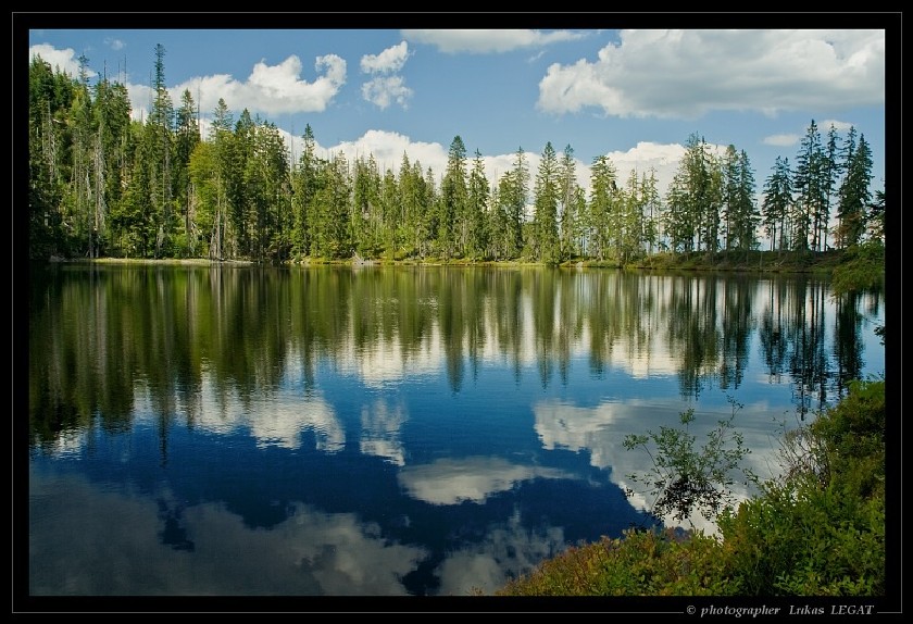
Prášilské jezero
Prasilske jezero je jednim z peti ceskych sumavskych ledovcovych jezer. Lezi na vychodnim vybezku hory Polednik (1.315 m) ve vysce 1.080 m nad morem asi 5 km jihovychodne od obce Prasily a asi 10 km zapadojihozapadne od Srni.
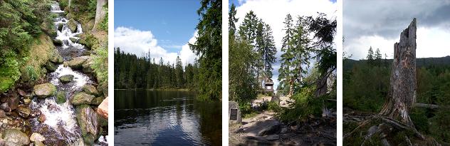
Jezero se rozklada v ledovcovem karu, ktery ma tvar obraceneho kuzele s vrcholem posunutym k jezerni stene, jez cni nad jezerem do vysky 150 m. Je hrazeno celni 9 m vysokou morenou. Az 280 m dlouhe a 180 m siroke jezero ma obvod 730 m a plochu 3,91 ha. V jezere, ze ktereho vyteka Jezerni potok, je zadrzeno 275.000 m krychlovych vody. Prumerna hloubka ciní 7,5 m, v nejhlubsich mistech dosahuje az 15 m.
V blizkosti je bazinata kotlina, ktera je zrejme zbytkem dalsiho dnes jiz zarostleho jezera. Podle starych lidovych povesti v jezere prebyva divukrasna panna se zlatymi vlasy a modrýma ocima, ktera laka svym tklivym zpevem kolemjdouci pocestne k sobe do hlubin. Protoze se voda z jezera vyuzivala pri plavbe dreva, byla jeho hraz umele navysena. Na hrazi je pomnicek venovany studentovi mediciny O. Koreisovi, ktery se zde utopil.
Oblast Prasilskeho jezera byla v minulosti krajinou, kam nebyl pristup povolen. S odstranenim hranicniho pasma se i tato oblast stala pristupnou pro navstevniky. Jezero i s horou Poledník tvori prirodni rezervaci o rozloze 158 ha.
Pristup k jezeru je mozny z obce Prasily po cervene znacce (4,5 km). Z parkoviste asi 2 km vychodne od Prasil smerem na Srni vede k jezeru trasa zluté znacky s napojenim na zelenou a cervenou (3,5 km).
Ledovcova jezera
V obdobi asi pred 10 000 lety, v horskych udolnich oblastech, ktere byly drive pokryty ledem doslo vlivem zmeny klimatickych podminek k postupnemu vzniku jezer. Led, ktery puvodne pokryval horska udoli, zacal postupne tat a po jeho roztati po nem zbyla v udoli voda. Jelikoz ledovce casto ustupovaly do nizin, modelovaly udoli a tahly pred sebou morenu (celni val zeminy a kameni), ktera po roztati ledu zamezila odtoku vznikle vody.
Cache
Pro uznani teto cache musite splnit nasledujici podminky:
1) Ponorte se do hlubin jezera a zmerte jaka je jeho nejvetsi hloubka ;)
2) Vyfotte se u jezera (po změně pravidel nepovinné).
Odpoved zasilejte pres profil a fotografii nahrajte k logu.
Prášily Lake
Prasilske Jezero (Prasily Lake) lies on the slope of Polednik Peak ("Noon Mount" - 1,315 m), 1,080 above sea level, about 5 kilometres south-east of the small village Prasily and about 10 km south-west of the village Srni.
It is one of five morainic lakes in the Czech part of the Sumava mountains (Bohemian Forest). It is about 280 m long and 180 m wide lake with girth 730 m. The lake is 3.91 ha large and the deepest point is at 15 m. The moraine, which holds 275,000 cubic metres of water, is 9 m high. The rock face towers above the water level to the height 150 m.
The lake pier forms a mound of 9 m height formed of granite boulders and two smaller moraine mounds. The water flows from a lake through Jezerni potok (Lake Brook) to Kremelna-river, which is a tributary of Otava, Vltava and Elbe-rivers.
On the shore there is a stone memorial to O. Kareis, a student who got drowned here in 1927.
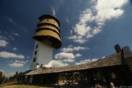
Behind the lake (9 km further down the trail) there is the Polednik Peak (1315 m above sea level) with its 37 m high observation tower which was open to the public in 1998. It offers magnificent views of the central Sumava and the Bavarian Forest. When the weather is good, one can see as far as the Alps.
This area along the border was forbidden for the public in the second half of the 20th century, during the communist era. Now it is protected in a nature reserve (about 158 ha large) together with Polednik Peak.
The red marked path from Prasily (4.5 km) leads to the lake. The access is also possible from the parking-lot which lies about 2 km east of Prasily (in the direction of the village Srni) along the yellow sign continuing along the green one and then the red one (about 3,5 km).
Glacial Lakes
A glacial lake is a lake with origins in a melted glacier. Glacial lakes can be green as a result of pulverized minerals (rock flour) that support a large population of algae.
A retreating glacier often leaves behind large deposits of ice in hollows between drumlins or hills. As the ice age ends, these will melt to create lakes. These lakes are often surrounded by drumlins, along with other evidence of the glacier such as moraines, eskers and erosional features such as striations and chatter marks.
Cache
To claim this earthcache you will need to do the following:
1) How deep is the deepest point in the Prasily Lake?
2) Take a photo with GPS and the Prasily Lake.
E-mail us through our profile the answers.
Zdroj / Information:
http://www.jiznicechy.org/cz/index.php?path=prir/prasil.htm
http://www.jiznicechy.org/en/index.php?path=prir/prasil.htm
http://www.sumavanet.cz/mszapad/prasily.asp?lng=en
http://en.infoglobe.cz/moutains/europe/czech-republic/sumava-bohemian-forest/articles-to-mou ntains/prasily-lake/#detail