Am Infozentrum auf dem Hoherodskopf beginnt ein sieben Kilometer
langer geologischer Pfad, welcher zu einer Reise durch die
Erdzeitalter einlädt. Er endet in Ilbeshausen-Hochwaldhausen. An
den Wochenenden und Feiertagen zwischen Mai und Oktober fährt die
Buslinie "Vulkanexpress" zum Ausgangspunkt der Wanderung zurück.
Diese letzte Station lehrt die Entstehung, das Alter und den
Kreislauf der Steine. Vor über 4 Milliarden Jahre war unsere Erde
eine glühende Kugel aus Magma. Alle Elemente, aus denen sie
besteht, waren bereits vorhanden. Als sie began sich abzukühlen,
bildete sie langsam ihren jetzigen Aufbau: Die schweren Elemente
sammelten sich in der Tiefe und die leichteren im Erdmantel. Erst
eine Milliarde Jahre später, als die Oberflächentemperatur sank,
bildete sich eine feste Kruste. Im Erdinneren wirken die Kräfte bis
heute: Die Hitze im Erdkern erzeugt Strömungen und bringt Bewegung
in die Kruste. Die einzelnen Kontinentalplatten schwimmen auf dem
zähflüssigem Erdmantel, stoßen aneinander, schieben sich
übereinander oder trennen sich. An den Plattenrändern tauchen
riesige Gesteinsplatten in den Erdmantel, wo sie aufgeschmolzen
werden (Subduktion), während anderswo neue Landmassen durch Vulkane
entstehen. Auch von außen wirken Kräfte auf die Erde: Sonne, Wind,
Kälte, Eis und Regen führen zur Verwitterung von Gesteinen an der
Oberfläche. Gebirge werden abgetragen, Sande und Geröll
verschoben.
At the information center on the Hoherodskopf a seven
kilometers long geological path begins, which invites to a journey
through the geological eras. It ends in Ilbeshausen-Hochwaldhausen.
At weekends and holidays between May and October the busline
"Volcano Express" goes back to the starting point of the hike. This
last station teaches the origin, age and the cycle of stones. More
than 4 billion years ago, the Earth was a fiery ball of magma. All
the elements which constitute it, were already present. When it
began to cool, it gradually formed its present structure: the heavy
elements gathered in the depths and the lighter in the mantle. Only
one billion years later, when the surface temperature dropped, it
formed a solid crust. In the interior the forces are still at work
today: The heat in the Earth's core generates currents and brings
movement in the crust. The different continental plates are
floating on the viscous mantle. They encounter each other, they
slide over together or they separate. At the plate boundaries huge
slabs of rock plunge into the mantle, where they are melted
(subduction), while elsewhere, new land masses are created by
volcanoes. Even from the outside forces acting on the earth: sun,
wind, cold, ice and rain lead to the weathering of rocks on the
surface. Mountains erode, sand and gravel is shifted.
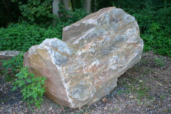
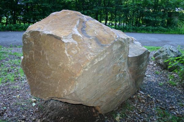
Um die Log-Erlaubnis zu erhalten:
a) Schieße ein Foto von dir und deinem GPS-Gerät beim Gneis ohne
die Daten der Infotafel zu zeigen! [optional seit 1. Janauar
2011]
b) Beantworte mir über mein Profil folgende Fragen: Wie heißt die
Periode des Erdalterums, in der dieser Gneis entstand? Aus welcher
Region stammt er und wie alt ist der Stein? Gesteine werden nach
der Art ihrer Entstehung in drei große Gruppen unterschieden.
Benenne die Gruppen, die in einem ständigen Kreislauf miteinander
verbunden sind!
To get permission to log:
a) Take a photo of yourself and your GPS device at the gneiss
without showing details of the table! [optional since 1 January
2011]
b) Use my profile to answer the following questions to me: What is
the period of the Palaeozoic this gneiss is originated? Where does
it come from and how old is the stone? Rocks are differentiated in
three major groups the way they came into being. Name the groups
that are connected in a constant cycle!
Unvollständige bzw. fehlerhafte Logs werden gelöscht. Ich
versuche stets zeitnah Logfreigabe zu erteilen.
Incomplete or incorrect logs will be deleted. I always
try to give permission promptly.