The Cantilever EarthCache
-
Difficulty:
-

-
Terrain:
-

Size:  (not chosen)
Please note Use of geocaching.com services is subject to the terms and conditions
in our disclaimer.
Overview
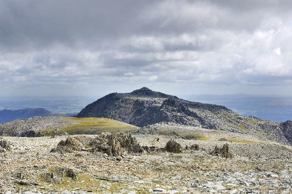
The Glyders, or more correctly Y Glyderau, are one of the most expansive areas of land above 2000ft in Wales, and are a major feature of the Snowdonia National Park. The range runs from Mynydd Llandegai in the north-west to Capel Curig in the south-east, and sit between two of the area's major mountain passes, The Pass of Llanberis (Nant Perris) in the south and Nant Ffrancon (Cwm Ogwen) in the north. These valleys separate the Glyders from Snowdonia’s highest mountains, with Snowdon to the south and the Carneddau to the north. As a result the mountains offer some of the best views in the whole of Snowdonia and have been the vantage point for many a postcard photo.
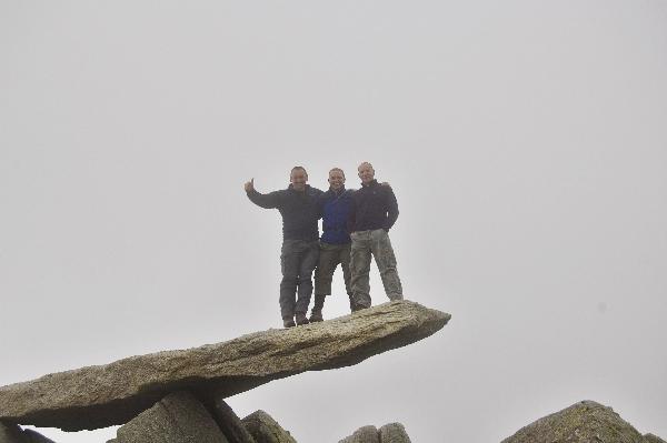
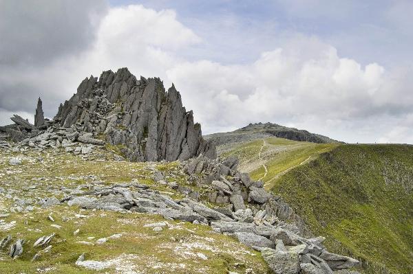
Among the ranges most distinctive features are the heavily weathered summits of Glyder Fawr and Glyder Fach which are characterised by a series of large rocky tors. The tors were formed during the last ice age when the mountain tops protruded above the ice, and were exposed to thousands of years of intense weathering. These features such as Castell y Gwynt and "The Cantilever Stone" offer some fantastic bouldering opportunities in a stunning setting.
Glyder Fach is the smaller neighbour of its sister peak Glyder Fawr. At 995m it is the second highest peak in the Glyder Range and is also one of the most impressive. During the last ice age the summit of the mountain protruded above the ice sheet and was exposed to a harsh Arctic climate that heavily weathered its bedrock. This weathering led to the summit becoming covered by a myriad of broken stone and boulders capped by several large tors, from one of which the famous cantilever stone protrudes. One of these tors is the famous Castell y Gwynt,(that translates as Castle of the Wind) which is situated to the west, sitting astride a broad ridge that connects the two Glyders. This tor offers a superb foreground to photographs of Snowdon it also presents some hugely entertaining bouldering set within a dramatic location. Although when viewed from Snowdon the mountain appears unimpressive and rounded, its northern slopes consist of a series of steep cliffs riddled with deep gullies and jutting buttresses.
The mountains are also home to Llyn Idwal, one of Britain’s most beautiful and most ecologically important lakes. Lying in a deep hanging valley in the shadow of the Devil's Kitchen it is an extremely popular destination for rock climbers, walkers and anglers. Its habitats are considered to be so special that it is protected by both international European law as a Special Area of Conservation and a Ramsar site.
Another of the ranges famous lakes is the Llyn Marchlyn Mawr Reservoir on the northern flank of Elidir Fawr, which is used by the Dinorwig Power Station, as part of a 1728 MW hydroelectric pump-storage system, that operates through a man-made cavern within the mountain. At times of peak electricity use, water is quickly pumped through six 288MW turbines reaching peak production within 6 seconds.
Geology
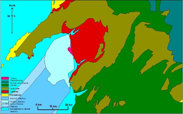
The main structural feature of Snowdonia is of course the broad belt of rugged mountains that runs diagonally across it through from the Carneddau to Snowdon, with the Glyders forming the central mass of peaks. It corresponds with the complex downfold of Ordovician rocks known as the Snowdon syncline. The oldest rocks (Pre-Cambrian) in the region are found to the of the range on the island of Anglesey. They consist of metamorphosed sedimentary and volcanic rocks over 6000m thick, highly deformed by earth movement. Lower Palaeozoic rocks mark the development across the area of a great depositional trough in which accumulated thousands of metres of marine sediments. The lower rocks (Cambrian) rest unconformably on the older formations. This trough marks the establishment of a sedimentary basin that covered all of Wales, much of England, parts of Ireland and extended into Belgium. The basin was situated on the edge of a continental mass which lay to the south-east, with the Iapetus Ocean on the north-west. At the end of the Cambrian, slight uplift exposed the erosional deposits, and a new period of submergence during the Ordovician, led to more deposition and more unconformity.
Volcanic activity is the outstanding feature of the Ordovician period. Vulcanism spread throughout the region and eventually culminated in eruptions of central Snowdonia giving birth to Glyderau as well as Snowdon and the Carneddau. This volcanic activity coincided with the continued deposition of marine sediments and was a prelude to the later closure of the Iapetus Ocean. Though volcanic activity ceased at the end of the Ordovician, marine sedimentation continued into the Silurian. At the end of the Silurian, earth movements culminated in the Caledonian orogeny, a major period of uplift, folding and fracturing which partly destroyed the marine trough and resulting in the closure of the Iapatus Ocean and the resultant continent-continent collision. The Lower Palaeozoic seas retreated from North Wales and the strong earth-movements transformed the landscape, and the marine rocks of the Cambrian, Ordovician and Silurian periods were replaced by the continental rocks of the Devonian period. Subsequent erosion has revealed the major Caledonian structures such as the Snowdon syncline and the Harlech dome just to the south (Rhinogs). The Devonian period is followed unconformably by strongly transgressive Carboniferous rocks. The marine transgression in the Carboniferous covered most of North Wales with only the highest mountains probably remaining unsubmerged as islands. A second period of major earth movement (Hercynian) affected the Carboniferous and older rocks, with the main movements occurring along existing fractures. Apart from Pleistocene and recent sediments, no post Hercynian sedimentary rocks are found in Snowdonia. During the Tertiary era, North Wales was situated at the edge of a landmass which was undergoing uplift in relation to the development of the North Atlantic Ocean. The uplift of the landmass during the Tertiary resulted in intensive erosion of overlying rocks, exposure of the Lower Palaeozoic rocks forming the Snowdon syncline and Harlech dome, and development of an upland plateau. The uplift resulted in the dominant primary drainage directions of the North Wales area.
The river systems formed part of an extensive drainage system draining the uplifted continent towards the south-east. The denudation of the mountains and the carving out of the valleys took place in stages. In parts of Snowdonia, imperfect plateau surfaces occur, probably the result of erosion controlled by higher base levels (river erosion). They were primarily developed by river erosion controlled by an intermittently falling base level (rejuvenation). Some of the plateau surfaces (below 180m) are thought to have been marine cut and end abruptly as if along a cliff line. The low-level coastal platforms are definitely pre-glacial and the whole series of erosion plateau surfaces indicate a falling base level in the Tertiary period. The higher surfaces are thus older than the lower ones and are less well preserved. Rivers in the Tertiary rejuvenation, exploited structural weaknesses and created some river capture, which in turn caused more rejuvenation. All evidence now points to the fact that the Glyder area was deeply dissected by rivers attempting to grade themselves to a succession of lower base levels, down to levels less than 60m above sea level. Although glaciers have considerable deepened the valleys and later-glacial rivers also, the main valleys and mountain outlines were already in existence prior to the Pleistocene glacial phases e.g. Nant Ffrancon and The Pass of Llanberis. The modern physical landscape and geography of Snowdonia mainly reflects the influence of intensive glacial erosion during the Pleistocene epoch. During the late Pleistocene glacial phase, a large British Ice Sheet developed in response to global cooling. This ice sheet developed by coalescence of several ice centres, one of which was centred in North Wales. Welsh ice was centred on the Migneint plateau and the Arenig Mountains with outlet glaciers radiating from that centre. These outlet glaciers carved fairly extensive glacial trough valleys, some good examples are the valleys of Nant Ffrancon and Pass of Llanberis. Deposits were dredged in frozen conditions from the floor of the Irish Sea by ice approximately 700m thick. During phases of more severe climatic conditions, Welsh ice quickly spread over the coastal plains and south Anglesey preventing the Irish Sea ice from advancing. Erratics from the mainland have been recorded on the west of Anglesey, so the coast was subject to Welsh and Irish ice at different times, thus tills of both are found. During this period the tops of the highest peaks protruded above the ice sheet as nunataks, with large areas around Snowdon, the Glyderau and the Carneddau undergoing extensive periglacial weathering. The majority of glacial landforms found beyond the mountain areas were last formed or modified during the last glacial maximum approximately 18,000 yrs BP (Dimlington Stadial). The freshest glacial deposits and landforms plus those found in high mountain areas were last formed/modified during the last glacial even (Loch Lomond Stadial or Younger Dryas) approximately 11,000 - 10,000 yrs BP. Snowdonia is an area which once supported local glaciers during the Loch Lomond Stadial. Glaciers emerged from the cwms and were channelled down existing valleys (carved during the previous glacial phases), and in a few cases carved out new ones. The post-glacial landscape evolution has largely developed through landscape adjustments especially isostatic rebound (uplift), slope modification and coastal processes (including sea-level rise).
As with all high mountain walks, please go prepared with waterproof clothing, stout boots and plenty of water. The weather can change very quickly and be cool even in summer, you will see people in pumps and flip flops though this is definitely not recommended.
Just a note of thanks to "Happy Landins" for their Help and Guidence to us, to set this Cache
In order to log this cache
1. Please take a picture of you and your group standing on the Cantilever stone, with Gps. Dont worry it will not move, see pics....
Also email answers to the following questions do not post answer on cache page.
1. What is the bearing as you walk along the stone, North, South, East, West, or somewhere in between.
2. The Tors that protruded above the ice during the last ice age have a specific name..... what is it? (The answer is on the Cachepage)
3. Just for fun... Estimate the weight of the Cantilever Stone

Additional Hints
(Decrypt)
Nccebk 40 lneqf Rnfg bs Tylqre Snpu Fhzzvg. Lbh Pna'g zvff vg !!