Stone Forest EarthCache
-
Difficulty:
-

-
Terrain:
-

Size:  (not chosen)
Please note Use of geocaching.com services is subject to the terms and conditions
in our disclaimer.
Stone Forest is a fabulous natural phenomenon most known with its
Bulgarian name of "Pobitite Kamani", which means "stones beaten
into the ground".
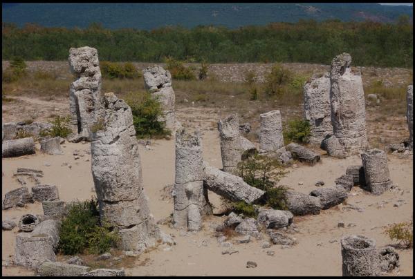
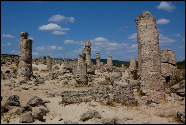
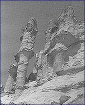
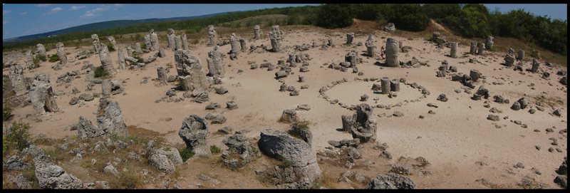 These are numerous limestone pillars as high as 10 m, hollow or
solid cylinders, truncated cones or single rocks and cliffs.
Nowadays is believed that these carbonate - cemented sandstone
structures were formed due to microbial methane oxidation around
natural gas seepages - so called "bubbling reefs". The cementation
occurred in the sub bottom marine sands some 50 million years ago
and now is exposed by subsequent erosion of the surrounding
unconsolidated sediments and vertical tectonic movements of the
earth crust.
These are numerous limestone pillars as high as 10 m, hollow or
solid cylinders, truncated cones or single rocks and cliffs.
Nowadays is believed that these carbonate - cemented sandstone
structures were formed due to microbial methane oxidation around
natural gas seepages - so called "bubbling reefs". The cementation
occurred in the sub bottom marine sands some 50 million years ago
and now is exposed by subsequent erosion of the surrounding
unconsolidated sediments and vertical tectonic movements of the
earth crust.
The spectacular landscape of "Pobitite Kamani" is spotty spread in
a North - South orientated belt about 3 km wide and 8 km long. The
stones are clustered in seven large groups and several separate
small areas embracing a total area of more than 7 square
kilometers.
The structures of "Pobitite Kamani" consist of carbonate - cemented
sand and silt deposits of Lower Eocene age, the same sediments in
which they occur. Except of the exposed on the earth surface forms
they are develop in another one to three underground levels more
(all four levels can be observed clearly on the outcroppings in the
"Karierata" site – west part of the country). The forms of any
level usually grow upon a solid limestone substratum most probably
with the same origin.
The main, "Dikilitash" group is the most impressive and in a best
state of preservation. The place is easy reachable by the road E70
which crosses it approximately 18 km west of Varna and is site of
organizing tourism. It comprises some 300 big and small pillars in
large strips (about 850x120 m) and over 50 ones in a smaller spot
southward. Some of them are broken into two or three segments;
other lay down, looking as being excavated from their roots.
Several basic hypotheses about the genesis of the phenomenon have
been developed ranging from designing of the structures by
mechanical acting of the environmental factors (wind, rain, sea
waves) to the precipitation of carbonate from percolating ground
waters (stalactite mode of formation) to coral complexes, algal
bioconstructed build-ups and lithified forest. The answer of the
origin was recently found in the Kattegat area of gas seepages,
offshore Denmark where the modern submarine landscape "the bubbling
reefs" is very similar to those of "Pobitite Kamani" (see two
images et the end of the page).
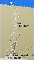
Natural gas seepages are known from many places all over the
World, both on land and offshore. They occur where suitable
pathways have been developed from the gas source to the surface.
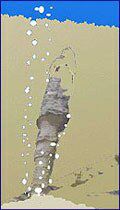
Once gas migration path established a methane oxidation occurs
inducing precipitation of carbonate which litifies the sediment
along gas channel (see "genesis 1").Cementation of the sediment
goes on around the methane pathway, fills channel and the pillar
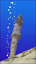
structure grows from outside. Similar process may occur laterally
forming a substratum layer (see "genesis 2").Exposure of the
carbonate - cemented sandstone structures on the seafloor happens.
As a result of submarine and earth surface erosion of surrounding
unconsolidated sediments due to sea levels droppings and risings
(see” underwater"). After many, many years with the help of
vertical tectonic movements of the earth crust the result of these
processes is exhibit now to make us admire to these miraculous
sculptures. (See outcrop "Karierata").
|
|
|
|
| genesis 1 |
genesis 2 |
underwater |
Karierata |
However, the recently obtained scientific results suggest that
carbonate formation in the area of "Pobitite Kamani" may have more
complex origin and continues today by precipitation of carbonates
from meteoric groundwater.
To log this Earth Cache
1. Take a photo of yourself, your GPS and one of the stone “trees”
Answer by email the following questions
2. How big is the area - square kilometers ?
3. What is the height of the tallest “tree”?
Additional Hints
(No hints available.)