Geolehrpfad Kreuzeck EarthCache
-
Difficulty:
-

-
Terrain:
-

Size:  (other)
Please note Use of geocaching.com services is subject to the terms and conditions
in our disclaimer.
Geolehrpfad beim Kreuzeuckhaus mit Information über die Enstehung der Umgebung
Geological learning path by the Kreuzeckhaus with information about the originate of the enviroment.
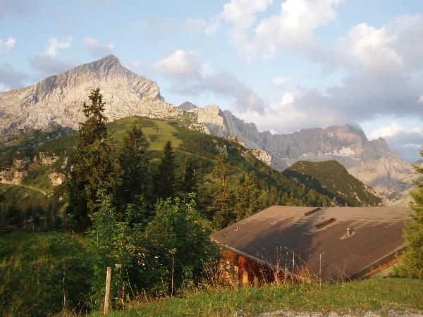
Während unserer Hüttentour im August 2009 haben wir im Kreuzeck-Haus übernachtet – ein schöner Ausgangspunkt für Spaziergänge zur Hochalm und zum Osterfelderkopf sowie auf die Alpspitze (2628 m, mit Klettersteig). Das Kreuzeck-Haus, auch unter dem Namen Adolf-Zoeppritz-Haus bekannt, ist mit der Kreuzeck-Bergbahn von Garmisch oder zu Fuß, zum Beispiel von Hammersbach über das Waldeck, einfach zu erreichen. Beim Kreuzeckhaus startet auch ein Geo-Lehrpfad, welcher über die Hochalm zum Osterfelderkopf führt. Vom Osterfelderkopf geht es mit der Alpspitzbahn wieder nach unten. Der Lehrpfad ist ca. 2 km lang (400 Höhenmeter).
Entstehung der Wettersteingebirge
Der Kalk des Wettersteingebirges entstand vor vielen Jahrmillionen, wie auch bei den nahe gelegen Massiven, aus Ablagerungen im Tethysmeer. Mächtige Schichten aus Muschelschalen und Korallen wurden zu Gestein verpresst, das später (im Rahmen der Kontinentaldrift) aufgefaltet wurde.
Die formenden Kräfte wirkten hierbei in Richtung Norden, denn die afrikanische Platte schob sich vor ca. 60 Mio. Jahren gegen Europa.
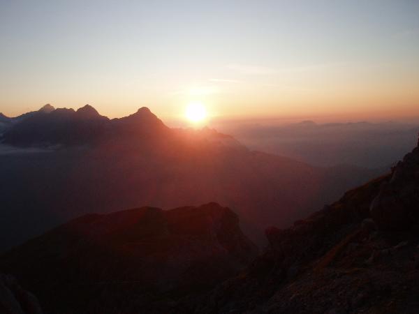
 Die heute zu sehende Struktur der Oberfläche ist weitgehend auf die Errosionswirkung zurückzuführen. Ein Resultat dieser natürlichen "Schöpfung" ist beispielsweise die Nordwand der Alpspitze), die sicherlich zu den schönsten Wand-Pyramiden im nördlichen Alpenraum gehört. Die heute zu sehende Struktur der Oberfläche ist weitgehend auf die Errosionswirkung zurückzuführen. Ein Resultat dieser natürlichen "Schöpfung" ist beispielsweise die Nordwand der Alpspitze), die sicherlich zu den schönsten Wand-Pyramiden im nördlichen Alpenraum gehört.
|
Um diesen Cache zu erfüllen, musst mann vorläufig ein Frage beantworten, weil Infotafel G1 verschwunden ist. Das Antwort findet mann an der Infotafel G13 (Es ist also nicht notwendig, den kompletten Pfad zu gehen.)
Station G1 (Frage 1) findet man hier: N 47° 27.057 E 011° 03.992
Bitte machen Sie ein Foto von sich oder einem persönlichen Gegenstand an der Stelle, an der sich ehemals das Infotafel G1 befand und lade es hoch beim Log.
Station G13 (Frage 2) findet man hier: N 47° 27.006 E 011° 03.976
Bitte senden Sie mir das Wort, das in diesem Bild durch Fragezeichen ersetzt wurde: 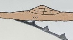
Logs ohne Foto oder ohne Antwort können gelöscht werden.
English
During our holiday in August 2009 we have stayed in the Kreuzeckhaus, a good place to start a walk to Hochalm, Osterfelderkopf or the Alpspitze (2628 m. / Via Ferrata). The Kreuzeckhaus, also knowned as Adolf-Zoeppritz-Haus, can be reached very easy by cable-lift "Kreuzeckbahn" from Garmisch, or by feet; for example from Hammersbach via Waldeck. In the neighbourhood of the Kreuzeckhaus also starts a geological path, which leads via Hochalm to the Osterfelderkopf. From Osterfelderkopf you can take the cable-lift "Alpspitzbahn" back to Garmisch. The geological path is ca. 2 km (400 metres climbing)
Origin of the Wettersteingebirge
The lime of the Wetterstein mountains arised millions of years ago, in the same way as the nearby mountains, from deposits in the "Tethys"lake. Immense layers of mussel shels and corals were pressed into stone, which were unfolded later (within the framework of continental drift).
The forming forces worked hereby in direction Northern, because the African plate shoves for ca. 60 million years against Europe.
 The current visible structure of the surface can be reduced to the working of erosion. The current visible structure of the surface can be reduced to the working of erosion.
A result of this natural "creation" is for example the northern wand of the Alpspitze, which is for sure one of the most beautiful "wall-pyramids" in the northern Alps.
|
To log this cache you have to answer 1 question for now, because sign G1 has disappeared. The answer can be found at sign G13 (so it's not necessary to walk the whole path)
Sign G1 (Question 1) is located at: N 47 27.057 E 11 03.992
Please make a picture of yourself or a personal item at the place where sign G1 used to be and add it yo your log.
Sign G13 (Question 2) is located at: N 47 27.006 E 11 03.976
Please send me the word that has been replaced by question marks in this picture:
Logs without a picture or answer sent to me can be deleted.
Additional Hints
(No hints available.)