PLEASE NOTE: There have been a proliferation of cache logs received recently where answers to the earthcache questions are never sent. This will no longer be permitted. I reserve the right to delete all logs not meeting this basic earthcache requirement. Effective 8/12/20, all cachers must submit an email or a message with answers to the questions below, ideally before, but within seven days of logging this cache as a find. I understand there are times when access to the internet is limited. When that is the case, I will be happy to work with you on timelines if needed.
Mount Sunflower was designated the Kansas high point in 1961. The elevation was officially plotted at 4,039 feet by a United States Geological Survey. It is located in Wallace County, on the Harold family ranch just east of the Kansas-Colorado border. The lofty summit (if you can really call it that!) is more than 3,300 feet above the state's topographic low point in Montgomery County in southeastern Kansas. According to the Kansas Geological Survey, much of Mount Sunflower's formation is due to the uplift of the Rocky Mountains during the Cretaceous period of geologic time approximately 80 million years ago.
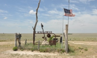
A common definition of a mountain is “a natural elevation of the earth's surface rising more or less abruptly to a summit”. One need only glance at the surrounding landscape to see that Mount Sunflower is not a mountain at all but is better described as High Plains prairie landscape.
Be prepared to drive long distances on gravel roads to reach this special place. There are no restroom facilities nearby, though the landowners have graciously provided a covered picnic area. There is no admission fee to visit Mount Sunflower. You may encounter cattle during your visit; they are harmless and this is their home. Please remember that you are a guest on private property when visiting and be respectful of the area at all times.
In order to log this cache as a find, please send me an email or message with answers to the following questions:
- Determine the change in elevation from the beginning of the “final approach” to the top of Mount Sunflower. With your GPSr, take a measurement of the elevation at the final turn on your way "up" to Mount Sunflower. Subtract this measurement from Mount Sunflower's elevation.
- Please also answer the following: Mount Sunflower was designated as the Kansas high point in what year? What geological process caused the formation of Mount Sunflower?
Although not required, feel free to post lots of photos. I love looking at them!

Information for the development of this EarthCache came from the websites for the Kansas Geological Survey, University of Kansas; and the Wallace County Economic Development Alliance.
I would like to thank the Harold family for granting permission for this EarthCache. While in the area, don't forget to log the virtual cache, Mount Sunflower Conquest, GC2A76.

Congratulations to Pullings for being First to Find!
