Chaîne des Puys EarthCache
-
Difficulty:
-

-
Terrain:
-
Size:  (other)
Please note Use of geocaching.com services is subject to the terms and conditions
in our disclaimer.
English
Français
Deutsch
!!!
As long as the access to WP3 and WP4 is denied, please do these tasks at WP5.
L'accès est interdit au WP3 et WP4. Pendent il est comme ca, réalisez ces exercises au WP5.
So lange der Weg zu WP3 und WP4 gesperrt ist, bitte diese Aufgaben an WP5 erfüllen.
The Chaîne des Puys is a chain of 80 volcanoes which developed 90,000 to 6,000 years ago. They stretch across 30km from north to south.
La Chaîne des Puys possède 80 appareils volcaniques. Les premières éruptions ont eu lieu il y a 90 000 ans environ, les plus récentes il y a moins de 6 000 ans. Les volcans sont alignés du Nord au Sud sur environ 30 kilomètres.
Die Chaîne des Puys ist eine Kette aus etwa 80 Vulkanen, die vor 90.000 bis 6.000 Jahren entstanden ist. Sie erstreckt sich über 30km von Nord nach Süd.
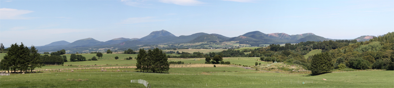
You can find here divers volcanic forms. The most of the volcanoes in the chain belong to the type Stromboli. They produce thin lava and mostly shape simple craters. They consist of basalt. The Puy de Pariou is belonging to this form.
Ici on trouve diverses formes volcaniques. La plupart des volcans sont de type strombolien à cratères simples. La lave étant généralement assez fluide. Ces volcans sont formés de basalte. Le Puy de Pariou appartient à ce type.
Man findet hier verschiedene vulkanische Formen. Die meisten der Vulkane der Kette weisen den Stromboli-Typ auf. Sie fördern dünnflüssige Lava, bilden meist einfache Krater und bestehen aus Basalt. Zu dieser Form gehört auch der Puy de Pariou.

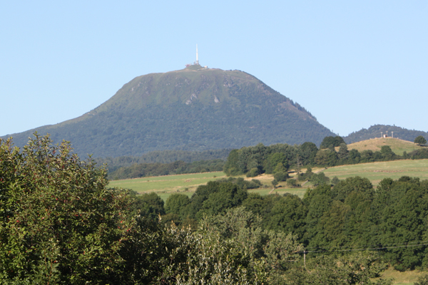
The other type of volcanoes you can discover here exists of trachyte, locally named dômite. The lava is very viscous, builds domes, and is rich of silicate. The stones are grey. Eruptions of this type of volcanoes (Pelée type) can be very explosive. Like the Puy de Dôme most of these domes are located in the middle of the chain.
L'autre type de volcans est formé de trachyte, localement appelé dômite. La lave est très visqueuse, forme des dômes et est riche en silice. Les rochers sont gris. Ce type de volcans (type Peléen comme la montagne Pelée en Martinique) peut être très explosif. Comme le Puy de Dôme la plupart de ces dômes se trouvent au cœur de la Chaîne des Puys.
Der andere hier vorkommende Vulkantypus besteht aus Trachyt, lokal auch Dômit genannt. Die Lava ist zähflüssig und bildet Kuppeln. Sie ist reich an Silizium. Das Gestein ist grau. Ausbrüche dieser Art der Vulkane (Pelée-Typ) können sehr explosiv sein. Wie der Puy de Dôme befinden sich die meisten Kuppeln dieses Typus in der Mitte der Chaîne des Puys.
Your tasks:
Vôtres exercises:
Deine Aufgaben:
WP1: N45° 48.262 E2° 58.963 / WP2: N45° 48.271 E2° 58.519
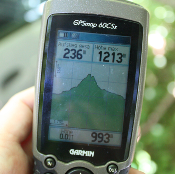
Park at WP1 and go onto the Puy de Pariou. At WP2 you can decide if you are going the sunny south west route or the woody north route. We ascended in the north and descended in the south east. It was a trip of 6km.
Laissez la voiture à WP1 et montez au Puy de Pariou. A WP2 vous pouvez choisir entre la route sud qui est ensoleillée ou la route nord boisée. Nous sommes montés au nord et descendus au sud est. C'est une randonnée de 6km.
Parke an WP1 und gehe auf den Puy de Pariou. An WP2 kannst Du Dich entscheiden, ob Du die sonnige Südwestroute oder die bewaldete Nordroute nehmen willst. Wir sind im Norden hinauf und im Südosten herunter und sind dabei 6km gewandert.
WP3 WP5: N45° 47.724 E2° 58.199
(OPTIONAL) Take a photo of you and your GPS with the Puy de Dôme in the background. Add this photo to your log.
(OPTIONEL) Prenez une photo avec vous et votre GPS, avec le Puy de Dôme au fond. Joignez la photo à votre log.
(FREIWILLIG) Mache an WP3 ein Foto von Dir und Deinem GPS-Gerät mit dem Puy de Dôme im Hintergrund. Lade das Foto später mit Deinem Log hoch.
WP4 WP5: N45° 47.722 E2° 58.272
Go to WP4. Draw a sketch of the crater before you and the puys behind it. Name two of the puys. A map can be helpful. Take a photo of the sketch and add it to your log.
Allez au WP4.Dessinez une esquisse du cratère devant vous et des puys en arrière-plan. Nommez au moins deux des puys. Peut-être une carte pourrait être utile. Prenez une photo de l'esquisse et joignez la photo à votre log.
Gehe zu WP4. Mache eine Skizze vom Krater, der vor Dir liegt und den Puys hinter dem Krater. Benenne mindestens zwei der Puys. Hier kann eine Karte der Gegend hilfreich sein. Fotografiere die Skizze und füge das Foto Deinem Log bei.
WP5: N45° 47.789 E2° 58.428
At WP5 you find an information panel. Send us a mail with the 3 phases of erosion (green text). The mail should reach us not later than the log notification.
À WP5 vous trouvez un panneau d'information. Envoyez par mail les 3 phases de l'érosion (texte vert). Le mail doit arriver avant la notification du log.
Malheureusement le panneau est détruit. Dans nous souvenir il y a un deuxième panneau avec les réponses au fond de la montagne (descendre sud est l’escalier au WP5). Si c’est juste, écrivez-nous, s’il vous plaît, avec des coordonnées. Merci!
An WP5 steht eine Informationstafel. Schreibe uns eine Mail mit den 3 Phasen der Erosion (grüner Text). Die Mail sollte spätestens mit der Benachrichtigung über Dein Log eintreffen.
Additional Hints
(No hints available.)