The Cathedral / La Catedral
Introduction
Mount Teide or, in Spanish, El
Teide, is the highest elevation of Spain and the islands of
the Atlantic (it is the third largest volcano in the world from its
base) is 3.718 meters. Is an active volcano which last erupted in
1909 from the El Chinyero vent on the Santiago (northwestern) rift
and is located on Tenerife, Canary Islands. The volcano and its
surroundings comprise the Teide National Park
(Parque Nacional del Teide in Spanish). The
park has an area of 18900 ha and was named a World Heritage Site by
UNESCO on June 29,
2007. It is also from the end of 2007 one of the
Twelve Treasures of Spain. Territorially belongs to the
municipality of La Orotava.
At 3718 m above
sea level, and approximately 7500 m above the floor of the Atlantic
Ocean, Teide is the highest mountain in Spain, highest point in the
Atlantic Ocean and the 13th highest mountain in the European Union
(highest mountain not in the Alps).(Note: The actual summit stands
3 meters (10 ft) higher than the triangulation station, and
associated bench mark, which has an altitude of 3,715 m
(12,188 ft)). The island of Tenerife itself is the third largest
volcanic ocean island on Earth by volume. Teide is also the third
highest volcano on a volcanic ocean island. It is also unstable and
possibly in a more advanced stage of deformation and failure than
the much publicized Cumbre Vieja. The United Nations Committee for
Disaster Mitigation designated Teide as a Decade Volcano, because
of its history of destructive eruptions and its proximity to
several large towns, of which the closest are Garachico, Icod de
los Vinos and Puerto de la Cruz. Teide together with its neighbour
Pico Viejo and Montaña Blanca form the Central Volcanic
Complex.
Within the Teide National Park occur
many different volcanic features of which La Catedral is but one.
The supplied coordinates are of this rock formation. Parking is
available at N 28º 13.392’ – W 16º 37.838 and from
there choose the best view of The Cathedral.
La Catedral is one of the best examples of
“phonolyte necks” in the Cañadas del Teide
crater.
Phonolite
Phonolite is a rare igneous, volcanic (extrusive) rock of
intermediate (between felsic and mafic) composition, with aphanitic
to porphyritic texture.
The name
phonolite comes from the Greek meaning (more or less) "sounding
stone" because of the metallic sound it produces if an unfractured
plate is hit, hence the English name clinckstone.
Phonolite is
unusual in that it forms from a highly silica undersaturated melt
by low degrees of partial melting (less than 10%) of highly
aluminous lower crustal rocks such as tonalite, monzonite and
metamorphic rocks. Melting of such rocks to a very low degree
promotes the liberation of aluminium, potassium, sodium and calcium
via melting of feldspar, with some involvement of mafic minerals.
The melt formed is silica undersaturated (i.e.; quartz is absent
from the melts or solidified rocks), with feldspathoid species
dominating over feldspar species in the melt.
Phonolite
occurrences are associated with a few geological processes and
tectonic events, which can lead to the melting of appropriate
precursor lithologies. These include intracontinental hotspot
volcanism, such as may form above mantle plumes covered by thick
continental crust. A-type granites and alkaline igneous provinces
are usually associated with phonolites. Phonolites may also be
produced by low degree partial melting of underplates of granitic
material in collisional orogenic belts.
Phonolites, as
they are products of low degree partial melts, are silica
undersaturated, and have feldspathoids in their normative
mineralogy.
Mineral
assemblages in phonolite occurrences are usually abundant
feldspathoids (nepheline, sodalite, hauyne, leucite and analcite)
and alkali feldspar (sanidine, anorthoclase or orthoclase), and
rare sodic plagioclase. Biotite, sodium rich amphiboles and
pyroxenes along with iron rich olivine are common minor minerals.
Accessory phases include titanite, apatite, corundum, zircon,
magnetite and ilmenite. Phonolites are silica under-saturated, as
illustrated by the position of phonolite in the TAS classification
and QAPF diagrams.
The
EarthCache
The idea behind this EarthCache is to
show you how “phonolite necks” are formed.
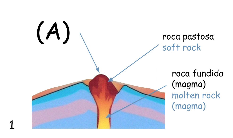
During the eruption the rock in the
volcano conduit was molten (1).
After the eruption the magma cooled
down very slowly and solidified. As the rock contracted, prismatic
joints were formed (2).
Long afterword, erosion and
meteorization destroyed the volcano. However, the highly resistant
rock of the volcano conduit was left standing out on the landscape
(3).
To validate your “found”
log for this EarthCache you need to:
1 - On photo 1's legend there is an
(A), please e-mail me what is exactly written at its place on the
"TheCathedral" infoboard;
2 - Draw a sketch of The Cathedral
with the estimated height of this rock formation and upload
it.
3 - (Optional) Upload a photo
of you and your GPSr with The Cathedral on the
background.
ATTENTION: Any log
without sketch upload will be deleted within a week’s
time.
___________________________________________________________________________
Las coordenadas dadas son de la
formación rocosa. Puede aparcar en N 28º 13.392’ – W
16º 37.838 y desde ahí elegir el mejor local para mirar a La
Catedral
Esta formación rocosa es uno de
los mejores ejemplos de “pitón fonolítico” en la
cratera de Cañadas del Teide, situado a mas de 2000 metros de
altitud.
Con esta Earthcache se pretende
enseñar como son formados los “pitones
fonolíticos”.
Durante la erupción la roca de la
chimenea volcánica estaba fundida (1).
Después de la erupción, el magma
solidificó, enfriándose muy lentamente; al contraerse la roca se
formaron fisuras con forma de prisma (2).
Mucho tiempo después la erosión
destruyó el volcán. La roca de la chimenea volcánica quedó
sobresaliente en el paisaje
(3).
Para tener su log validado usted
tiene que:
1 - En la legenda de la foto 1
hay un (A), por favor envíe-me un e-mail con lo que estay
exactamente escribido en su lugar en el infoboard de "La
Catedral";
2 - Hacer un pequeño dibujo de La
Catedral con su altura estimada y hacer su upload;
3 - (Opcional) Hacer el
upload de una foto suya con el GPSr y La Catedral como
fondo.
ATENCIÓN: Logs
sin el upload del dibujo serán apagados en una
semana.
Sources:
http://en.wikipedia.org/wiki/Phonolite
http://en.wikipedia.org/wiki/Teide