🇬🇧 It is not allowed to stop your car at the island or at the bridge! And it is dangerous! For safety reasons, it should be a passenger who takes the photos.
🇩🇰 Det er strengt forbudt at standse bilen på øen eller på broen! Og det er farligt! For din sikkerheds skyld bør det være en passagerer der tager billederne.
🇸🇪 Det är inte tillåtet att stanna bilen på ön eller på bron! Och det är farligt! För din säkerhets skull bör en passagerare ta bilderna.
🇩🇪 Es ist nicht erlaubt anzuhalten, während der gesamten Querung über den Öresund! Zudem wäre es sehr gefährlich, daher solltet ihr einen Beifahrer dabei haben der die Bilder machen kann!
Logging requirements: 


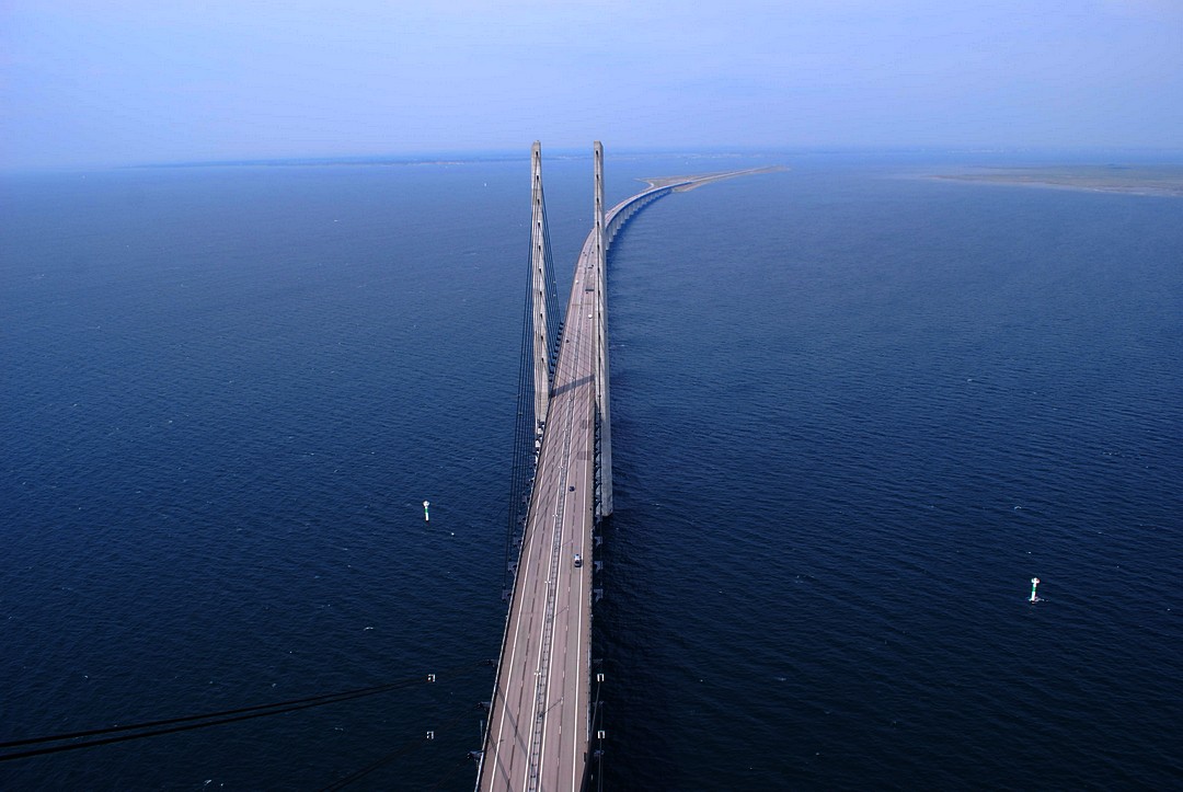
Picture taken by iPowl (© 2008 iPowl). Thanks for the permission to use it here!
🇬🇧 The islands Peberholm (the artificial island where the EarthCache coordinates are placed) and Saltholm (the Island North of Peberholm) is the very top of a large underwater formation between Denmark and Sweden, called the Drogden shelf [Drogdentærskelen, Limhamnströskeln]. The shelf, with shallow waters (less than 8 meters/24 feet) has it's Southern edge about where the windmill park is placed and it's Northern edge about 5 kilometers/3 miles North of the bridge. On both sides of the shelf (North and South), the water is much, much, deeper.

The Drogden shelf is an important geological formation for the conditions in the Baltic sea. The shelf prevents water to run freely from the Kattegat sea/the North sea into the Baltic sea and normally most water is running North over the shelf. Once in a while, when the meteorological situation is perfect, the water is changing running direction and salty water from the ocean is running into the Baltic sea, this phenomena is called a ”water breakthrough”. Without the shelf, the water in the Baltic sea would have been almost as salty as the ocean and if the shelf would have been just slightly higher so it would have prevented the water breakthroughs, the Baltic sea would have consist of a much larger share of fresh water from the some 200 larger rivers around the Baltic sea. As it is now, with the shelf placed where it is, the water in the Baltic sea is brackish [brakvand/bräckt vatten/brackwasser]. It is though not only the water direction in Øresund that regulates the salt level in the Baltic sea, as there are also two other large sounds between the Baltic sea and the North sea.
The shelf between Malmö and Copenhagen is also the reason for why the Øresund bridge is built in Southern Øresund, where the distance between the Danish and Swedish coastline is long, and not between Helsingborg and Elsinore (Helsingør in Danish), where the distance is much shorter but the water much deeper. The engineers evaluated that it would be easier to build a bridge in shallow waters than in deep, even though the length of the bridge has to be much longer. Maybe also the fact that Copenhagen and Malmö are much larger cities than Elsinore and Helsingborg is part of the equation...
Peberholm (pepper islet) is named in contrast to the larger natural island to the North, Saltholm (salt islet). The artificial island is a very interesting place for understanding development of nature. When the island was ready, it was left in it's post glacier conditions as it was in order for the scientists to see in what way Nature would claim it's rights and how fast. No people are allowed to enter the island by foot, but every year, the flora and fauna is investigated by Danish and Swedish scientists.
To log this cache you have to:
1. If passing by car: Take a photo of the road-sign with the EU-flag ( ) and the country name (either “Danmark” or “Sverige”, depending on which direction you are passing the Øresund bridge) when passing the national border east of Peberholm, close to the additional waypoint. Get you GPS unit in the picture. Again – it is not allowed to stop your car at Peberholm or at the bridge!
1. If passing by train: Take a photo of yourself, your GPS-unit and the view from the top of the bridge, all in one picture.
1. If passing by boat: Take a photo of yourself and your GPS-unit with Peberholm or Saltholm in the background.
2. Take a nice or interesting photo of own choice from Peberholm or the bridge.
3. Post your log along with the pictures taken.
4. Send a message to the cache owner (Löjan) with an estimation of the maximum elevation of the Saltholm island (the bigger island North of the island you are driving on when passing Øresund).
Since this it a quite frequently logged Earth Cache, we would appreciate if you do no. 3 and no. 4 at the same time.
Do not post the solutions to the task (4), just send it in the message. If no e-mail is sent to the cache owner, or if the answer is very much off the track, we reserve the right to delete the log after one reminder. You do not have to wait for any confirmation from us to log. If you need to add additional information, we will contact you.
Note: Due to new rules for Earth Caches, logs will not be deleted for not containing the required photos.
För att logga denna cache ska du:
1. Om du åker bil: Ta ett foto av vägskylten med EU-flaggan ( ) och landsnamnet (Danmark eller Sverige, beroende på i vilken riktning du passerar Øresundsbron) när du passerar landsgränsen öster om Peberholm, nära additional waypoint-flaggan. Ta med GPSen i bilden. Kom ihåg – det är inte tillåtet att stanna bilen på Peberholm eller på bron!
1. Om du åker tåg: Ta en bild av dig själv, din GPS och något av utsikten från toppen av bron, allt i samma bild.
1. Om du åker båt:Ta en bild av dig själv och din GPS med antingen Peberholm eller Saltholm i bakgrunden.
2. Ta en fin eller intressant bild efter eget val från Peberholm eller bron.
3. Posta loggen tillsammans med bilderna du tagit.
4. Sänt ett meddelande till cacheägaren (Löjan) med din uppskattning av hur hög Saltholms (den större ön norr om Peberholm) högsta punkt är.
Eftersom detta är en ganska välbesökt Earth Cache vore vi tacksamma om du gör punkt 3 och punkt 4 samtidigt.
Var snäll och posta inte lösningen på uppgiften (4), utan sänd den bara i meddelandet. Om inget meddelande sänds är cachen inte 'hittad' och vi förehåller oss rätten att ta bort loggen efter en påminnelse. Detsamma gäller om din uppskattning av högsta punkt är väldigt fel. Du behöver inte vänta på bekräftelse för att logga - om något behöver kompletteras hör vi av oss.
Notera: Pga nya regler för earchcacher så kommer inga loggar att raderas bara för att de inte innehåller de foton som krävs.
For at logge denne cache skal du:
1. Hvis du kører i bil: Tage et billede af vejskiltet med EU-flaget ( ) og landenavnet (Danmark eller Sverige, afhængigt af hvilken retning du passerer Øresund) når du passerer landegrænsen øst for Peberholm, tæt på addtitional waypoint-markeringen. Få med din GPS i billedet. Husk – man må ikke standse bilen på Peberholm eller på broen!
1. Hvis du kører i tog: Tag et billede af dig selv, din GPS og nogle af udsigten fra toppen af broen, det hele i det samme billede.
1. Hvis du sejler:Tag et billede af dig selv og din GPS med enten Peberholm eller Saltholm i baggrunden.
2. Tag et smukt eller interessant billede efter eget valg fra Peberholm eller broen.
3. Upload billederne sammen med din log.
4. Send en besked til cache owner (Löjan) med dit bud på maximale højde af Saltholm (den store ø nord for Peberholm).
Venligst upload (3) og send beskeden till cache owner (4) på det samme tidspunkt.
Lad venligst være med at skrive svaret på opgaven (4) i loggen, men send det i beskeden. Hvis der ikke bliver sendt en besked, eller hvis dit bud er meget forkert er cachen ikke 'fundet' og logen kan derfor blive slettet. Du behøver ikke vænte på svar før du logger found – hvis der mangler någle oplysninger vil du høre fra os.
Notera: Pga nya regler för earchcacher så kommer inga loggar att raderas bara för att de inte innehåller de foton som krävs.
Um den Cache zu loggen müssen folgende Aufgaben erfüllen:
1. Wenn ihr mit dem Auto fahrt: Mache ein Foto von dem Straßenschild mit der EU-Flagge () und dem Ländernamen (entweder „Danmark“ oder „Sverige“, das hängt natürlich von eurer Fahrtrichtung ab). Wenn du die Grenze östlich von Peberholm passierst, nahe dem Wegpunkt/Waypoint mache ein Bild mit GPS. Und nochmals: Es ist nicht erlaubt anzuhalten!
1. Wenn ihr mit dem Zug fahrt: Mache ein Foto von dir, deinem GPS und dem Blick vom höchsten Punkt der Brücke, alles in einem Bilde.
1. Wenn ihr mit dem Boot fahrt: Mache ein Foto von dir und deinem GPS mit Peberholm und Saltholm im Hintergrund.
2. Mache ein interessantes Foto von Peberholm oder der Brücke. Motiv nach eigener Wahl.
3. Schreibe dein Log mit den dazugehörigen Bildern.
4. Schreibe eine Nachricht an den Cachebesitzer (Löjan) mit der geschätzten maximal Höhe von der Saltholm Insel (die große Insel nördlich von Peberholm, der Insel mit den Koordinaten)
Da dies ein ziemlich häufig geloggter Cache ist, wäre ich euch verbunden wenn ihr Nr. 3 und 4 gleichzeitig macht.
Schreibe die Antwort zu Nummer 4 nicht im Log, sondern sende sie in der Nachricht! Wenn der Besitzer keine Nachricht erhält oder die Antwort weit daneben liegt, wird der Log gelöscht. Auf eine Bestätigung muss nicht gewartet werden, sollten Informationen fehlen werden wir uns melden.
Vielen Dank für die Übersetzung mustermannxx!
Note: Due to new rules for Earth Caches, logs will not be deleted for not containing the required photos.