[DE]
Im Juni 2009 wurde das deutsch-niederländische Wattenmeer durch die Welterbe-Kommission der UNESCO als Weltnaturerbe anerkannt. Das Gebiet umfasst die Flächen der Wattenmeer-Nationalparks in Schleswig-Holstein und Niedersachsen sowie eines Schutzgebiets in den Niederlanden mit einer Gesamtfläche von 10.000 Quadratkilometern. Mitten im Nationalpark Niedersächsisches Wattenmeer – und somit jetzt mitten im Weltnaturerbe – liegt die Insel Langeoog.
Wie alle ostfriesischen Inseln ist auch Langeoog eine nacheiszeitlich gebildete Düneninsel. Der geologische Prozess, der zur Entstehung dieser Inseln führte, begann vor ca. 10.000 Jahren. Anders als die nordfriesischen Inseln vor der Küste Schleswig-Holsteins und Dänemarks sind die ostfriesischen Inseln keine Überbleibsel früheren Festlands. Vielmehr entstanden sie durch Sedimentation, verursacht durch die Gezeiten und Fluten, die das Wasser in ständiger Bewegung halten, wobei die Strömungsrichtung mit Ebbe und Flut wechselt. Die Wassermassen transportieren dabei große Mengen von Sand, der sich im flachen Wasser bei geringerer Strömung ablagert. Dort wird er durch den Wellengang zu Strandwällen und Platen (Sandbänken) geformt, die durch Pionierpflanzen bewachsen und dadurch befestigt werden. Langeoog zeichnet sich dabei innerhalb der ostfriesischen Inseln durch eine besonders hohe Lagestabilität aus.
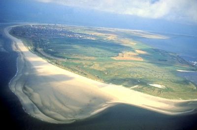
Das Flinthörn (Flint = Feuerstein und Hörn = Fluthaken) bezeichnet das Gebiet im äußersten Südwesten Langeoogs, südlich der im 19. Jahrhundert entstandenen Süderdünen. Es entstand als Folge der außerordentlich stabilen Lage Langeoogs aus einer eigenständigen, sich anlagernden Sandplate, der sogenannten Flinthörnplate. 1937 bis 1944 wurde, parallel zum Seedeich auf der Ostseite der Flinthörndeich erreichtet; bemerkenswert ist, dass das Deichvorland (die Salzwiese) und die Dünenlandschaft aber kaum vom Küstenschutz beeinflusst wurde. So ist hier bis heute die ursprünglichste auf Langeoog vorkommende Salzwiese erhalten geblieben, was vor allem an der natürlichen Entwässerung durch gewundene Priele deutlich wird.
Große Bedeutung hat der Bereich des Flinthörns als Brutgebiet für stark bedrohte Seevogelarten und als Rast- und Nahrungsgebiet für tausende von Zugvögeln.
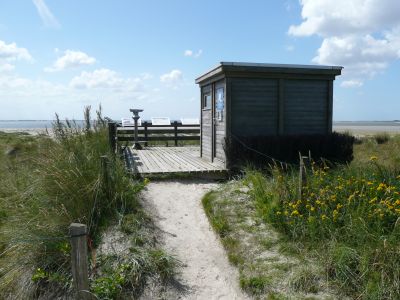
Das Flinthörn, das seit 1963 unter Naturschutz steht, ist heute Ruhezone des Nationalparks und darf damit ganzjährig nicht betreten werden. Um dem Besucher dennoch einen Einblick in die Entstehungsgeschichte und die Pflanzenwelt des Flinthörns zu ermöglichen, wurde ein Lehrpfad eingerichtet, der bei N53°43.900 E007°28.145 am Deichfuß beginnt und am Rande der Dünen bis zur Infohütte bei N53°43.584 E007°28.112 und weiter durch die Dünen an den Strand führt. Von der Aussichtsplattform an der Infohütte aus können bei Hochwasser verschiedene Vogelarten beobachtet werden. Der Pfad ist durch eine Pfahlreihe markiert und darf nicht verlassen werden.
Für diesen Cache gelten folgende Logbedingungen:
- Beantwortet folgende Fragen und sendet die Antworten an diese E-Mail-Adresse. Bitte gebt in der Betreff-Zeile Euren GC-Nicknamen an. Anschließend könnt Ihr sofort loggen. Sollten die Antworten nicht zufriedenstellend sein, werde ich mich bei Euch melden.
- Welche drei Dinge braucht eine Düne?
- Wie viele Wattschnecken oder Schlickkrebse pro Quadratmeter findet man im Wattenmeer?
- Welche am Flinthörnpfad vorkommende Pflanze verbirgt sich hinter der Tabakbezeichnung „Bahndamm, letzter Schnitt“?
- Wie hoch war der höchste Sturmflutwasserstand am Flinthörn und wann wurde er gemessen?
- Optional: Macht ein Foto von Euch auf dem Naturpfad, beispielsweise an der Infohütte und fügt es dem Online-Log bei. Dabei kommen natürlich Fotos von interessanten Menschen besser an als z. B. Fotos von langweiligen GPS-Geräten.
Viel Spaß!
[EN]
In June 2009, the UNESCO World Heritage Committee inscribed the Wadden Sea on the World Heritage List as a transboundary property of Germany and the Netherlands. The Wadden Sea comprises the Dutch Wadden Sea Conservation Area and the German Wadden Sea National Parks of Lower Saxony and Schleswig-Holstein with a total area of 10.000 suqare kilometres. In the middle of the Wadden Sea National Park of Lower Saxony – and thus now in the middle of the World Heritage – lies the island of Langeoog.
Like all the East-Friesian islands, the island of Langeoog is a dune island that has basically been formed in the post-glacial period. The geological process by which the islands came into existence began about 10,000 years ago. Unlike the North Frisian Islands on the coast of Schleswig Holstein and Denmark the East Frisian Islands are not remains of former mainland. Instead they were created by sedimentation caused by the tide and floods. They keep the water in constant movement and the direction of the current changes with the tides. These bodies of water are carrying a significant amount of sand. In shallow water, when the carrying capacity of the current is not sufficient anymore, the sand is deposited and the waves shape it into barrier beaches and Platen (sandbanks) which are reinforced by plant growth. Langeoog has proved to have the most stable location of the East Frisian Islands.
The Flinthörn (Flint = flintstone and Hörn = flood hook) names the southwesternmost area of the island of Langeoog, south of the Süderdünden (southern dunes) formed in the 19. century. It was formed due to Langeoog’s extraordinary stable location from a discrete sand Plate, the so-called Flinthörnplate, that attached itself to the main island. From 1937 to 1944, the Flinthörn dike was built in parallel to the sea dike on the east side; it is remarkable, that the dike foreland (the salt meadows) and the dune landscape have nonetheless not significantly been influenced by coastal protection. Thus, the most untouched salt meadows of Langeoog have been preserved here, which is particularly to be recognized from the natural drainage by meandering tidal creeks.
As breeding grounds for threatened seabirds and as resting and foraging grounds, the area of the Flinthörn has great importance for thousands of migratory birds.
The Flinthörn has been a nature protection area since 1963. Today it belongs to the rest-area oft the National Park and therefore may not be entered at any time. In order to deliver insight into Flinthörn’s history, flora and wildlife anyway, a nature trail was established. It begins at the dike-foot at N53°43.900 E007°28.145 and follows the dunes, leading to a viewing platform and an info cabin at N53°43.584 E007°28.112 and further on through the dunes to the beach. From the viewing platform at the info cabin, different kinds of seabirds can be watched during high tide. The path is marked by a file of piles and may not be left.
In order to log this cache, please:
- Answer the following questions and send your results to this e-mail-address. Please enter your GC nickname in the subject line. Afterwards you may log immediately. I will contact you if your answers are not satisfactory.
- What are the three things a sand dune needs to form?
- How many laver spire shells or sandhoppers per square meter can be found in the wadden sea?
- Which plant growing at the Flinthörn trail hides behind the tobacco name “Bahndamm, letzter Schnitt” (“railroad embankment, last cut”)?
- What was the highest storm flood water level at Flinthörn and when was it measured?
- Optional: Take a photo of yourselves on the nature trail, e.g. near the info cabin and attach it to your online log. Photos of interesting people are liked better, of course, than e. g. photos of boring GPS devices.
Have fun!