The Canadian Heritage Rivers System (CHRS) was established in
1984 to give national recognition to the important rivers of
Canada. It is a co-operative program between the federal and
provincial / territorial governments to conserve the features and
heritage values of significant rivers. Each government participates
on the Canadian Heritage Rivers Board to review nominations and
oversee the system. For a river to be included in the system it
must be of outstanding significance in one or more areas: human
history, natural history, or recreational value. The river must
also be managed to protect and enhance its heritage resources for
the benefit and enjoyment of future Canadians.
The Kicking Horse flows through the Eastern and Western Main
Ranges of the Canadian Rocky Mountains, leaving the Yoho National
Park downstream from Wapta Falls to tumble through the spectacular
lower Kicking Horse River Canyon to its confluence with the
Columbia River. The section of the river system designated a
Canadian Heritage River consists of the 49 km headwaters section
which lies within Yoho National Park, along with the 18.5 km Yoho
River, the Kicking Horse’s primary upstream tributary.
The Kicking Horse courses through one of Canada’s outstanding
natural heritage river environments, Yoho National Park. Its
watershed contains features which offer evidence of the earth’s
evolutionary history over a period of 600 million to 800 million
years. Most notable of these features are:
- the Burgess Shale, a UNESCO world heritage site containing
fossils of more than 140 species, dating back more than 500 million
years
- many of the highest peaks in the Canadian Rocky Mountains’
Eastern and Western Main Ranges, 28 of which exceed 2900 meters in
height
- ”U” shaped valleys and cirques representing long periods of
glacial activity
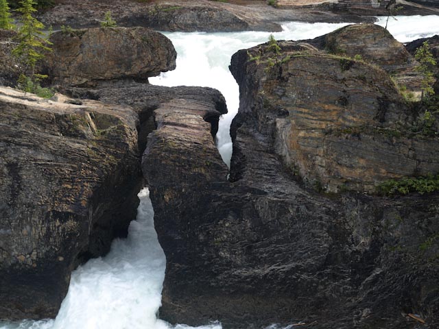
- fluvial erosion features such as river terraces, gorges,
hoodoos, alluvial fans, outwash plains and the natural
bridge that is the subject of this earthcache
- the Wapta and Waputik icefields
To claim your find, you must e-mail a short note to the cache
owner which contains all the following information:
- The text GC1WHDF Natural Bridge on the Kicking Horse River on
the first line.
- The number of people in your group.
- Explain the geologic processes that created the natural
bridge. You will find the necessary information on signs
installed at the site.
- As proof of visit, what is the topic of the signs posted 120
meters, 333 degrees true from the posted coordinates?
Photos of you or your GPS with the natural bridge in the
background would be most appreciated.
This earthcache was established with permission from Parks
Canada and complies with their geocaching guidelines. In granting
permission for this earthcache, Parks Canada conveyed that all
geocachers must stay on the designated trails and that no items are
to be removed or left at the site.
SOURCES: “CHRS – Kicking Horse River” on the internet at
http://www.chrs.ca/Rivers/KickingHorse/KickingHorse-F_e.htm#2,
on-site signage.