[EN]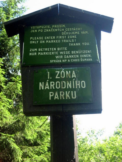 You can find it in the western part of Šumava range (Bohemian Forest) on the north-east slope of Debrník hill. Best way to reach it is to use blue touristic trail from the parking place in Nová Hurka. The place is reachable from both touristic trail and cycling route. Do not forget that you’re in the most protected part of the national park.
Today’s form of Šumava range and Bavarian Forest Mountains developed during Alpine folding some 60 millions years ago. As one of the oldest mountain ranges in Europe is formed from Paleozoic rocks mainly granite, gneiss and schist. It lies on the edge of influence of Atlantic and continental climate. There are small differences between temperatures and precipitation in winter and summer. Especially in higher places there uses to be a cold and wet climate. Mountain range is covered with trees with plenty of plateaus and mountain edges extended above occasionally. On Šumava there are many springs developing into rivers whose valleys complete the looks of the landscape. Both Šumave range and Bavarian Forest lies on main European water division between Black and Northern See. The shape of the mountains was formed by the instrumentality of glaciers during glacial periods. From these times remained on Šumava like survival numerous peat-bogs and glacial lakes, which are significant variegation of hydrological relations on Šumava and Bavarian Forest. Glacial cirques originated by the instrumentality of glaciers too. After the decline of the glaciers, there were felt natural glacial lakes that are a special hydrological feature of Šumava. They are located at an altitude of about 1000m. Their state is influenced by their acidification (caused by an increased amount of nitrogen and sulfur oxides in the air) due to acidic deposition and natural state of the lakes. In mid-seventies last remaining fish species were extinct and after that also crustaceans disappeared and the composition and occurrence of the plant had changed too. Unique ecosystems have developed here where the lead role was played by microorganisms in pelagial. Slight turns in events have happened after 1990 when the level of emissions has decreased. That is why the level of sulfur, nitrogen and ammonia ions has decreased while the pH of the water went higher. In the future, we will see if this change will lead to the renewal of original species. There were 11 glaciers on the slopes of the highest mountains in Šumava range about 10000 ago. These glaciers hollowed lake grounds surrounded by curved stone walls from front moraines. When the glaciers melted these hollowed basins were filled with water and formed originally 10 lakes. Some of these shallower lakes were silted with sediments and formed peat moores like Stará jímka next to Prášilské lake or northern corrie of Roklan. Nowadays we can visit 8 lakes lying about 1000 above see level on the level of snow line of those days. Five of those are located on the Czech side of Šumava Range; these are Lakes Laka, Prášilské a Plešné Lake in the area of National Park and Cerné and Certovo Lake in protected landscape area of Šumava. Remaining 3 lakes – Big and Small Javorské and Roklanské Lake are in the area of Bavarian Forest in Germany.
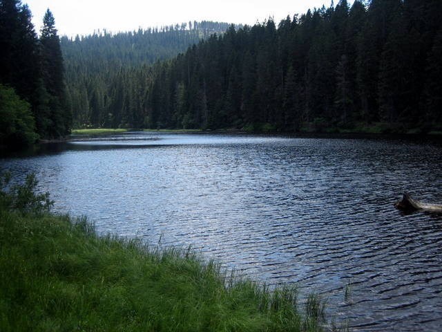
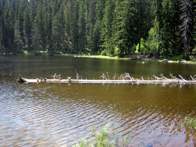
Lake Laka is the shallowest of all these lakes and it is the only one on the Czech side with islands and it is slowly being silted. Sediments have already been cleared (e.g. in the year 1906). Its flora is quite rich. On peat islands dominates mainly bent-grass (Carex canescens and C.nigra) and reed mace (Juncus bulbosus). The same plants grow on the lake’s strands. Among many kinds of algae are very rare ones listed on the Red List of Threatened Species (like Batrachospermum vagum or Binuclearia tectorum). In the last century, the lake was known as a home of many trouts, each year 400-500 was caught here and because of its breeding, the lake weir has to be heightened in the thirties. In the sixties, the trouts were still bred here but due to the waters’ oxidization, the fishes disappeared. Larger species living here are mainly eft (Triturus alpinus) and the great variety of spineless animals like dragonfly, stonefly, alderfly or sedge fly.
At the end of Tertiary during the cooling of climate there formed glacier from avalanches on the hill-sides. While they slowly melted they pushed in front a lot of loosened stones and rubble which formed great dykes which held melted glacier water after the last Ice age ended. Unique glacier lakes developed after the glaciers melted about 10-12 thousands year ago. While the glaciers moved they pushed in front of them big layers of debris which formed huge dykes so called moraine walls which held melting waters. Later the lakes became supplied by different streams and springs. In the whole Šumava Range we can find 8 lakes; three are in Bavaria and five are located on the Czech side. Lakes are in the middle of mountains forests. In the mountains’ valleys which used to be covered in ice, the lakes have formed due to climate changes. The ice which used to cover this valley started to meld and melted water had remained in the valleys. The glaciers often moved in the direction to the lowlands sculpturing the valleys and dragging with itself moraine (front walls of debris) which after the glacier had melted prevented the water from running out. In this fashion, the lakes were formed at the end of the Ice age also in the Alps, Scandinavia, Northern Germany, Poland or in Baltic states.
To log this Earthcache all you have to do is carry out two things:
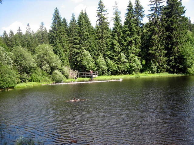
1) On your GPS take the measurements of altitude of right rear Corner of the wooden platform over the lake near the information boards and send me via profile the result
2) Take photo of yourself or your GPS with readable coordinates in front of the signpost with a visible signpost of Lake Laka (voluntary task)
[CZ] Leží v západní cásti Šumavy na SV svahu vrcholu Debrník. Nejrychlejší prístup je po modré znacce z parkovište v Nové Hurce. Je v dosahu znacené turistické trasy i cyklotrasy. Nezapomente, že jste v I. zóne Národního parku!


Základ dnešního masivu Šumavy a Bavorského lesa vznikl pri alpínském vrásnení v tretihorách asi pred 60-ti milióny let. Jako jedno z nejstarších evropských pohorí je tvoreno horninami prahorního a prvohorního stárí, zejména žulou rulou a svorem. Leží na rozhraní klimatického vlivu atlantského a kontinentálního podnebí. Typické jsou relativné malé rozdíly v teplotách a srážkových úhrnech mezi létem a zimou. Zejména ve vyšších polohách prevládá chladné a vlhké klima Je to zalesnené zaoblené pohorí s castými náhorními plošinami a místy vystupujícími vrcholy nejvetších Šumavských hor. Na Šumave pramení také nekolik rek, které dokreslují svými údolími ráz krajiny. Šumava i Bavorský les tvorí hlavní evropské rozvodí mezi Cerným a Severním morem. Tvár pohorí dále dokreslilo pusobení ledovcu v dobách ledových. Jako pozustatek techto dob zbyla na Šumave cetná rašelinište a ledovcová jezera, která jsou významným zpestrením hydrologických pomeru Šumavy i Bavorského lesa. Cinností ledovcu vznikly také kary. Po ústupu ledovcu pak za nahromadenými morénami zustala prirozená ledovcová jezera, která jsou specifickým hydrologickým jevem na Šumave. Vyskytují se v nadmorské výšce kolem 1000 m. Jejich stav je v soucasné dobe ovlivnen stupnem acidifikace (okyselení zpusobené zvýšenými koncentracemi oxidu dusíku a síry v ovzduší) v dusledku kyselé depozice a prírodních pomeru jezer. V polovine 70-tých let vyhynuly poslední prežívající ryby, pak prakticky vymizeli planktonní korýši a zmenila se druhová skladba i cetnost rostlinných druhu. Vyvinuly se unikátní ekosystémy s dominantní rolí mikroorganismu v pelagiálu. Urcitý obrat ve vývoji nastal po roce 1990, kdy došlo k podstatnému snížení emisí. V souladu s tím došlo k poklesu síranových, dusicnanových i amonných iontu a k vzrustu pH ve vodách jezer. Zda tyto zmeny povedou k obnove jezerních ekosystému ukáže budoucnost. Asi pred 10 000 lety bylo na svazích nejvyšších šumavských hor 11 ledovcu, které vyhloubily budoucí jezerní dna hrazená obloukovými valy celních morén. Po roztátí ledovcu se vyhloubené jímky naplnily vodou, a tak vzniklo puvodne 10 jezer. Jejich následné zanášení sedimenty zpusobilo úplné zazemení a zrašelinení melcích karu jako Staré jímky u Prášilského jezera nebo severního karu na Roklanu. Dnes mužeme navštívit 8 jezer ležících v nadmorské výšce kolem 1000 m, na hranici nekdejší snežné cáry. Pet z nich se nachází na ceské strane Šumavy - jezero Laka, Prášilské a Plešné na území NP, Cerné a Certovo jezero v CHKO Šumava, zbylá tri – Velké a Malé Javorské a Roklanské jezero leží v Bavorském lese na územní Nemecka.
Jezero LAKA je ze všech jezer nejmelcí, na ceské strane jediné s plovoucími ostruvky se sklonem k zazemnování. Dokonce byly jeho sedimenty v minulosti odstranovány (napr. v roce 1906). Jeho vegetace je pomerne bohatá - na rašelinných ostruvcích prevládají hlavne ostrice (Carex canescens a C. nigra) a sítina (Juncus bulbosus) a stejne tak brehy jsou lemovány temito druhy. Mezi množstvím druhu ras jsou i velmi vzácné rasy, uvedené v Cervené knize ohrožených druhu (jako napr. Batrachospermum vagum nebo Binuclearia tectorum). V minulém století bylo jezero známé množstvím pstruhu, kterých se rocne ulovilo 400 - 500 kusu a kvuli jejich chovu byla také v 30-tých letech 19. století zvýšena hráz. Ješte v 60-tých letech 20. století sem byli dosazováni pstruzi, ale následkem okyselování ryby i ve zdejších vodách vymizely. Z vetších živocichu zde mužeme zastihnout colka horského (Triturus alpinus), jinak se zde vyskytuje pomerne velké množství bezobratlých - vážky, pošvatky, strechatky, koretry nebo chrostíci.
Koncem tretihor v ledových dobách pri ochlazování klimatu se vytvorily na úbocích svahu ze snehových lavin ledovce. Pri postupném tání tlacily pred sebou množství uvolneného kamene a šterku, z nichž se pod svahy nakupily mohutné hráze, které zadržely vodu vzniklou z roztátých ledovcu po ústupu poslední ledové doby.
V horských údolních oblastech, které byly dríve pokryty ledem došlo vlivem zmeny klimatických podmínek k postupnému vzniku jezer. Led, který puvodne pokrýval horská údolí, zacal postupne tát a po jeho roztátí po nem zbyla v údolí voda. Jelikož ledovce casto ustupovaly do nížin, modelovaly údolí a táhly pred sebou morénu (celní val zeminy a kamení), která po roztátí ledu zamezila odtoku vzniklé vody. Tímto zpusobem vznikla koncem ledové doby ledovcová nebo karová jezera napr. i v Alpách, Skandinávii, Severním Nemecku, Polsku a Pobaltí.

Aby vám byl uznán log, musíte splnit 2 úkoly:
1) Zmerte za pomoci vaší GPS nadmorskou výšku pravého zadního rohu drevené terasy nad jezerem poblíž informacních cedulí na zadaných souradnicích a výsledek mi pošlete pres profil 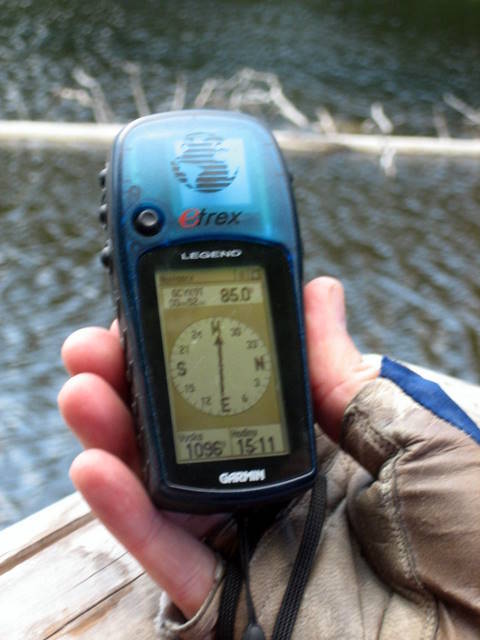
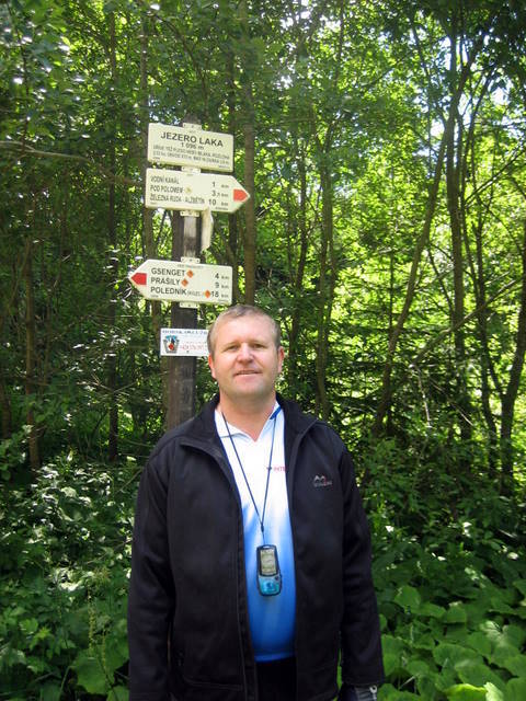
2) Vyfotte se u rozcestníku tak, aby byla videt tabulka Jezero Laka spolecne s vámi nebo s vaší GPS s citelnými souradnicemi (dobrovolný úkol)
[DE] Lacka-See ist der höchstgelegene und der kleinste Gletschersee in Böhmerwald.
Optimaler Ausgangspunkt ist der Parkplatz in Nova Hurka (Neu Hurkenthal).
Um Cache zu loggen sollten euch zwei Sachen nachzukommen:
1) Messt euch mit euren GPS die Seehöhe rechter hinterer Ecke der hölzernen Terrasse über den See bei Infotafeln. Die Antwort bitte per e-mail an mich.
2) Macht es einem Foto von euch oder euren GPS mit Wegweiser im Hintergrund. Das Foto hängt an euer Log an (freiwillige Aufgabe).
Logs ohne e-mail oder Foto werden gelöscht!
Sources/Zdroje:
RIHOVA AMBROZOVA, J. Ledovcova jezera, karova jezera. From Encyklopedie hydrobiologie : výkladový slovník [online]. Praha: VSCHT Praha, 2007 [cit. 2008-07-01]. Available from www: <http://vydavatelstvi.vscht.cz/knihy/uid_es-006/ebook.html?p=L003>
http://www.npsumava.cz/
wikipedie