The path is paved for only a little bit, most of it is hard pack but it can get rocky or muddy. Mountain bikes or jogging strollers will do fine. It is all downhill to the cache site (but that means it's all uphill back to your car). The slope is gentle, making for an easy walk, and the path is a favorite of long-time locals. I was concerned about ruining this special place by putting a cache here, but they told me that the more people that enjoyed the creek, the better, since there would be more people willing to defend it.
If you read nothing else below, read this:
The path to this cache is part of the City of DuPont Parks and Open Space. In early July 2009, the city of DuPont obtained easements to open this trail up to the public. However, this access could be removed at any time especially if users of the trail do not treat it with the proper respect. Please don't spoil it for others by littering or leaving the trail. This is a great opportunity for the caching community to show responsibility by practicing CITO (cache in, trash out).
The cache is not meant to be a difficult find, hopefully to reduce the risks of bushwhacking. But it is just off the main trail near a bridge that leads to the southern rim switchback trail, and could be easily exposed to muggles. Please take extra care when finding, examining, and replacing the cache so that muggles of the wrong sort don't see you. The hint below is a spoiler.
WARNINGS: (1) The cache is not near the active train tracks. Please do not approach them. (2) There is no poison oak at the cache site, but there are large amounts of it once you get to the beach, especially on the right side (facing the Sound). Don't let young ones go to play in the trees unless they know what they are doing. Here is what poison oak looks like. Please warn all members of your party. Leaves of three, let them be.
FTF, STF, and TTF prizes: Take one (your choice) of the following (all others please trade equal or up).
- Three arrowheads
- Homemeade soap
- Small leather pouch with Native American turtle design
- Fort Nisqually magnet
- Two DuPont magnets
- Fort Nisqually collector patch
Please enjoy your visit to this cache, the creek, and the beach, and feel free to share your pictures with us. A pdf map of the creek and local historic sites provided by the DuPont Historical Museum can be downloaded here. Now on to the good stuff...
Sources
The history that I have compiled below is not necessary to find this cache. I include it only because I was interested in learning more about the creek and thought others might be interested, too. There are current and ongoing controversies surrounding the creek that require a little perspective. Those who wish to debate these controversies would do well to learn about the creek's past. I am not a historian nor a naturalist, just an interested citizen. If there are any errors in what you read below, please contact me and I will correct them.
The more I learned about this area, the more intrigued I became. It is so rich in history and beauty, that I felt this cache deserved a more thorough description. So here are the fruits of my research. If you are interested, take some time to learn about the creek's past and what's going on with it today. You might want to print this out and read it as you walk the path to the cache.
My sources for all this material are:
A very special thank you to:
- Steve Wyant, DuPont resident and Sequalitchew Creek Watershed Council member
- Johanna Jones, Manager, DuPont Historical Museum
Sequalitchew Creek
From Nisqually-Sequalitchew.com:
For such a small, unassuming little creek, the Sequalitchew has been at the heart of some big events in the history of Washington State as well as some heated controversies that continue even to this day.
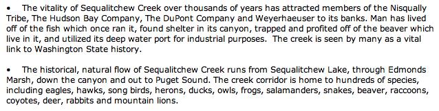
But it hasn't always been so small. Where today you can barely hear it in some places as you walk the trail, historically, it provided a wealth of salmon and trout to the Sequalitchew-Nisqually Indians who lived at its mouth. Even more recently, in the 20th century, the creek was strong enough to provide electricity for the DuPont Company's entire operation as well as the village where the employees lived.
So what happened to the creek and what is so controversial? Below I will present a brief history of events to demonstrate what a fascinating place this is and why it has been so pivotal to this region. This is not meant to be a complete history of the area, but hopefully it is enough to give you a picture of what life was like here in times past.
The history of Sequalitchew Creek is the history of DuPont itself. To make it simple, this history can be broken down into distinct periods: the Native American period, Fort Nisqually, the DuPont Company, and finally Weyerhaeuser and the Present Day. But first let's look at the natural state of the creek.
The Natural Creek
The creek begins at Sequalitchew Lake on North Fort Lewis, which in turn is fed by American Lake. The creek leaves the lake at its western tip and winds its way southwest into DuPont, crossing DuPont-Steilacoom Road approximately 900 feet south of the intersection with Center Drive. From here, it flows west and feeds Edmonds Marsh, a major wetland encompassing 130 acres which provides home to a great variety of flora and fauna as well as one infamous geocache.
After leaving the marsh, it heads west past the second Fort Nisqually site, under the Sequalitchew Creek Bridge, under Center Drive and then down into the canyon. From the History, dated 1994:
| Sequalitchew Creek emerges from Edmond Marsh, passes north of the DuPont village, and travels its last one-and-a-half miles to the sound. Here the Creek flows through a lush canyon, where its flow is augmented by underground flows from the Vashon aquifer and multiple springs, and several smaller seeps. For this reason, the canyon portion of the Creek can have a small flow, even when the Creek is slow or almost dry upstream. The steep-sided canyon is topped by the old DuPont Works Site. Within, it is thick with big leaf maples, red alders, vine maples, and sword ferns. The Creek side is lined with red huckleberry, creeping buttercups, salmonberry and mosses. Second-growth Douglas firs, western hemlocks, and western red cedars populate the upper reaches of the canyon walls and the plateaus above. Both canyon and Creek are home to a variety of wildlife. The Creek itself is populated with frogs (including the threatened red-legged frog), salamanders, perch, stickleback, bluegill, bass, cutthroat trout, coho, and chum salmon. A survey of wildlife on the DuPont site showed more than 130 species of bird, including great blue herons, ospreys, and a wide array of waterfowl. Residents have sighted bald eagles, deer, raccoons, muskrats, coyote, rabbits, foxes, mink, beaver, and river otters. One resident reported rumor of a black bear in the canyon several years ago. |
Though the creek flow is not what it used to be (more on this later), life in the canyon is still lush and stunningly beautiful. Please take some time in your log to comment on what you see especially if you have any encounters with the native wildlife.
Native Americans at Sequalitchew Creek
Archaeological evidence shows signs of man in this area for 5,700 years. While most specific locations important to the tribe of Sequalitchew-Nisqually Indians are not known outside the tribe (to prevent souvenir-gathering), we do know that the creek itself was a vital part of their daily life. From the History:
| Sequalitchew Creek is historically significant to the Nisqually Tribe, both as a fishery and as a cultural resource. The Sequalitchew Nisqually village was located at the mouth of Sequalitchew Creek until the first wave of European settlement, in the mid-1800's. The mouth of the Creek then was vastly different than today: Sequalitchew Creek met the sound as a wide shallow cove. The word Sequalitchew itself means "long, run-out tide." We believe this to be a description of the beaches at Sequalitchew Cove. |
Here is what it is believed the village looked like at the mouth of the creek. Note (obviously) that there is no railroad running along the beach. The Northern Pacific Railroad Company built the dike for the tracks in 1912. This effectively closed the cove as it was known to the Sequalitchew Tribe and turned the village area into a wetland (since the creek could not flow freely into the Sound). You will see all this at waypoint 2 though no parts of the village remain.
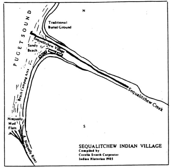
It is this village that Capt George Vancouver saw as he was surveying the west coast in 1792. Try to imagine seeing the free flowing creek, the shallow, open cove, and the two longhouses. It is no wonder that later expeditions would stop at this point and found the first European settlement in the Puget Sound region.
Fort Nisqually
It was 40 years later, in 1832, that Britain's Hudson Bay Company sought to expand its holdings in the northwest in order to be the leader in the lucrative fur trade. A small team of men arrived at the mouth of the Sequalitchew Creek that year and, in 12 days, built the Nisqually House, the first building on Puget Sound to be built by white men. The first Fort Nisqually followed the next year; it was placed on the bluff above the creek near what is today the golf course. In the following years, HBC built its presence there trading with and employing the local tribes as well as Hawaiians, Alaskans, Russians, and Americans. In 1837, the first steamship in the Sound, the S.S. Beaver, arrived to service the Fort.
In 1839 American Methodist missionaries arrived and set up their mission north of the creek. These were the first Americans to settle in the Puget Sound region. In 1841, American Lt. Charles Wilkes arrived and built an observatory on the bluff west of the Fort and south of the creek. This was used as a headquarters in surveying Puget Sound. A marker is currently set at what is believed to be the location of the observatory, and the city of DuPont has plans to build a park there. Together with the missionaries, Lt. Wilkes and his men conducted the first 4th of July celebration in the Sound.
By 1843, with the fur trade dwindling, the HBC shifted its focus to agriculture. In conjunction with this shift, Fort Nisqually was moved about a mile eastward next to the upper banks of the creek where more farmland existed. The site of the second Fort is visible as you drive along Center Drive. The remaining buildings of the Fort were moved to Point Defiance in 1934 in an effort to preserve them.
For the most part, relations between the natives and the employees of the Fort were never hostile. It wasn't until the 1850s when more and more American settlers began to arrive and claim land that hostilities began. In 1854, the Treaty of Medicine Creek, between the Washington Territory, the United States, and nine Native American tribes (including the Nisqually) was proposed but only offered the tribes meager lands away from their traditional homes. Chief Leschi of the Nisqually refused to sign (or signed under protest).
In October of 1855, violence between members of the Nisqually tribe and American militiamen marked the start of the Puget Sound Indian War. The war was a series of skirmishes that took place around the Sound over the course of the next year. While there were many tribes that were involved in the fighting against the Americans, it was Chief Leschi who was singled out by the American territorial governor. The Indians were outmanned and ran short of supplies, and in November of 1856, Chief Leschi was captured, and his brother Quiemuth surrendered shortly thereafter. Quiemuth was mysteriously murdered in the governor's offices while in custody, and Leschi himself was convicted of murdering an American militiaman. William Fraser Tolmie, then Chief Factor of Fort Nisqually, spoke out in defense of Chief Leschi, but his pleas were ignored and Chief Leschi was hanged in 1858. (In 2004, a Historical Court convened in Pierce County and exonerated him of any wrongdoing.)
The result of all this was the formation of the Nisqually Reservation and the removal of all tribal members to that reservation. Though the reservation was larger than originally outlined in the treaty and it was located along the Nisqually River, the members of the Sequalitchew-Nisqually village were forced to leave what had been their home for thousands of years.
With their success in the war, the Americans were left unopposed in their expansion. The Treaty of 1846 between the British and the Americans had defined the border at the 49th parallel, leaving Fort Nisqually and other HBC holdings within American territory. They were allowed to continue operating, but ongoing conflicts with encroaching settlers, tax collectors, and revenue agents made operation of the fort increasingly difficult. In 1869 HBC sold the fort and its properties to the American government. American homesteaders then moved in.
The DuPont Company
In 1906, a new player arrived in the form of E.I. du Pont de Nemours. With the aim of creating an explosives manufacturing plant, he and his company purchased all the land in what is now the city named after him. Employee homes were built along the back side of the 1843 Fort Nisqually site and later in what is now known as the Historic Village. Plant buildings were spread out all over the area (to provide adequate buffers in case of accidental explosions), and operations began in 1909. The following year, a narrow-gauge railroad system was built for transporting equipment and powder, and a wharf was constructed at the mouth of the creek for loading powder onto transport ships. The path that you will walk to the cache follows the creek and is in fact the narrow gauge railroad line that once connected the operational plant on the bluffs above to the wharf and the waiting ships below.
The Company took full advantage of the resources provided by the Sequalitchew Creek. A diversion of the creek was made just west of Center Drive, and the water was allowed to run along the top of the southern bluff and then plunge down the canyon wall to a powerhouse which was built about 300 yards up from the mouth of the creek. This system provided enough hydroelectricity to power the entire plant operations of the Company as well as the employees' homes. Water from the creek was also used to irrigate local farmland. Employees and families would go to the mouth of the creek in the fall armed with pitchforks to catch the plentiful salmon as they returned. And for recreation, the creek provided a natural swimming hole, and employees built picnic tables and even changing cabins alongside.
For 70 years, the DuPont Company operated and maintained this plant and transported its explosives for use all across the country. The town continued to grow with shops, a newspaper, a church, and schools, and in 1951, it was incorporated as a city and its houses were sold to the employees who lived there.
It was during the 1950s that a diversion to the creek was created just south of Sequalitchew Lake. Ft. Lewis receives much of its water supply from the lake, and if the upper creek were to back up into the lake (as it did when beavers built their dams), this could contaminate the water supply. The diversion was created, with the agreement of the DuPont Company, to ensure adequate water flow from the lake at all times. The diversion travels west from the lake, crossing DuPont-Steilacoom Rd about a half-mile north of the natural creek. It continues west then turns north to enter the Sound at Solo Point.
The original intent of the diversion was not to take away from the natural flow of the existing creek. But over time, without adequate oversight, creek levels began to drop.
Weyerhaeuser and Today's Controversies
In 1976, the DuPont Company packed up and moved out of town. A new owner, Weyerhaeuser, purchased all of the DuPont Company land with the intent of making a wood and paper products manufacturing center. It planned on using the DuPont Company's wharf to ship its products worldwide. Environmental groups objected to this plan, chief among them, the Nisqually Delta Association, due to the wharf's close proximity to the Nisqually Wildlife Refuge. Years of delays and lawsuits, including two visits to the state Supreme Court, produced no results, which is just how the environmental groups wanted it. Weyerhaesuser abandoned its plan for a wood products plant, but was moving forward with efforts to develop a residential and small business community called Northwest Landing.
In 1985, Weyerhaeuser discovered that much of the land it had purchased from the DuPont Company was contaminated with toxic chemicals. Land on both sides of the creek would have to be cleaned up before any further development could be undertaken. In cooperation with the DuPont Company, and with the oversight of the Department of Ecology, much of the area of the current golf course and a parcel of land north of the creek have been cleaned up over the past 20 years. As you're walking to the cache, you may wonder why only part of the path is paved with asphalt. This section of the rail bed was found to be contaminated with lead and arsenic. Ecology decreed that "capping" it with asphalt would be sufficient. Also, don't go digging around in the golf course; there might be bad stuff under there.
In the '90s Weyerhaeuser leased a portion of its land north of the creek to Lone Star Northwest (forebearer to Glacier Northwest which is now becoming part of Cal Portland) for the purpose of a gravel mine named Pioneer Aggregates. The proposed mine would install a conveyor belt system along the creek to transport mined gravel to the wharf to be shipped out via barge. Nisqually Delta Association and other groups took up the cause of the creek again. This time however a settlement was reached with all interested parties in 1994. The mine was approved, but a new transport facility was to be built near Solo Point. The creek and the wharf, along with a 200 foot buffer, would be protected from the mine. Pioneer Aggregates began operation in 1997. All was proceeding according to the agreement, until...
In 2007, Glacier Northwest put forth a proposal to expand the Pioneer Aggregates mine. The 178-acre expansion is southeast of the present mine, much closer to Center Drive, and a portion of it actually cuts into the Sequalitchew Creek ravine where the paved section ends, for about 3 football fields in length. To mine the gravel, groundwater must be removed, and Pioneer Aggregates is proposing the creation of a new, man-made "North Sequalitchew Creek". The new creek would be a drainage system for an underground aquifer and would feed into Sequalitchew Creek, of which the upper section back to center drive would go dry and the level of the marsh would drop by about 1.5' from current levels. The company argues that this system will increase creek flows, potentially allowing salmon to return to the creek. Opponents argue that the draining of the aquifer will lower the water table for other wetland areas including Edmond Marsh, causing them to dry up sooner.
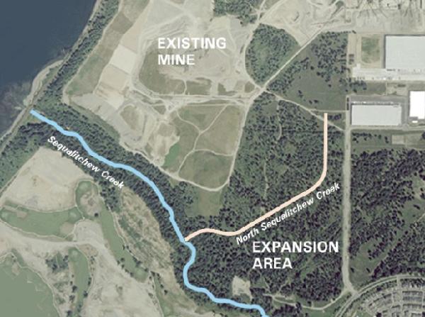
In January of 2009, the City Council approved the expansion of the mine with a few conditions. (1) Impacts on Edmond Marsh would be lessened by replacing invasive vegetation with native vegetation. (2) Any wetlands that would be removed would need to be replaced. (3) Excavation of the north side of the Sequalitchew Creek ravine would not be allowed, but a new pipeline would be installed to drain the new North Sequalitchew Creek into the existing creek.
A public hearing was scheduled for April of 2009, but was cancelled at the request of the applicant (Glacier Northwest). No reason for this cancellation was given, and at the time this cache is being published, no new date has been set.
Currently CalPortland is seeking to re-negotiate the 1994 Agreement which stated that they would "do nothing to affect the flows of Sequalitchew creek" along with "mining above the aquifer" and some other items they want changed to allow them to begin bulldozing. So, with the public and the city in a holding pattern waiting to see what will happen next in the expansion debate, let's re-visit the other controversial topic: the Ft. Lewis creek diversion. The diversion seems to have much greater flow than the upper creek and it's not at all clear that all that water is being diverted on purpose (there seems to be some inadvertant seepage from the creek to the diversion). Questions remain: Is Ft. Lewis really diverting that much water? Are they monitoring it? Is it truly necessary? With Pioneer Aggregates proposing a new creek which would restore flow to the lower creek, it makes one wonder why the city doesn't seek to limit the use of the diversion which would restore flow to the entire creek. In 1994, the DuPont City Council did pass a resolution to do just that, but nothing seems to have come of it. Perhaps it's time to re-visit this issue.
The Future of Sequalitchew Creek
Aside from the controversies regarding the creek itself, the city is moving forward with an end-goal of making the creek a protected and highlighted resource for all to enjoy. This includes formal trailheads with restrooms, maps, and signs near city hall and at a proposed new park at the site of the Wilkes Observatory. In addition, the city's plan calls for the creation of another park north of the creek near the mouth with views of the Sound, picnicking and other recreational opportunities.
Also, just south of the creek, a business and technology park is being planned which will surround the golf course. The park is a 260-acre development for office buildings, warehousing, and light industry. It will protect and highlight historical sites in the area and provide access to the creek trail.
Conclusion
Well, if you made it this far, congratulations! When you visit the creek and walk the path, you will see just how beautiful it is. Further, if you made it through all those words above, you may have an understanding of how important this creek was to the people who have lived and worked alongside it for hundreds and even thousands of years. If you want to be involved in the debate or just want to keep an eye on events as they happen, visit the city's website above or any of the other sites that monitor the creek. Above all, happy caching!