Rotes Moor EarthCache
-
Difficulty:
-

-
Terrain:
-

Size:  (not chosen)
Please note Use of geocaching.com services is subject to the terms and conditions
in our disclaimer.
Ein Foto der location wäre super!!
a picture of the location would be nice!!!
Parken: N 50 27.635 E 009 59.102
Deutsche Version:
Das Rote Moor
Das Rote Moor ist ein Hochmoor in der Hessischen Rhön. Es liegt im
Naturschutzgebiet gleichen Namens innerhalb des Biosphärenreservats
Rhön und ist Bestandteil des europaweiten Schutzgebietssystems
Natura 2000. Das Rote Moor ist nach dem in der Bayerischen Rhön
liegenden Schwarzen Moor (66,4 Hektar) mit 50 Hektar das
zweitgrößte Hochmoor in der Hohen Rhön. Das Rote Moor entstand,
nach der letzten Eiszeit vor etwa 12.000 Jahren. Im Tertiär
lagerten sich tonige Sedimente ab. Vor 25 bis 18 Millionen Jahren
förderten Vulkane ausgedehnte Lavaströme zu Tage, die zu
verwitterungsresistentem Basalt erstarrten. Während der letzten
Eiszeit lag die Rhön im Periglazialbereich, sie war also nicht von
Gletschern bedeckt. Große Hangmulden entstanden durch Firnerosion
und Bodenfließen. In Gebieten, in denen Wasser stauende Sedimente
wie Tone oder lehmige Verwitterungsrückstände der Basalte die
Mulden abdichteten, konnten sich über Niedermoorstadien Regenmoore
bilden. Die klimatischen Bedingungen mit hohen Niederschlagsmengen
sowie niedrigen Bodentemperaturen begünstigten das Moorwachstum.
Durch Pollenanalysen konnte die Entwicklung bis zur La-Tène-Zeit
zurückverfolgt werden.
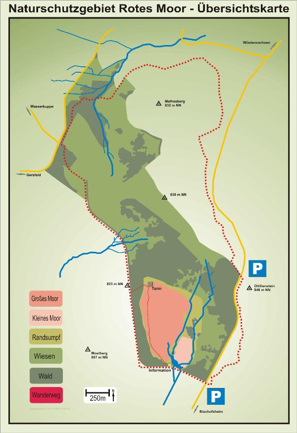
Das Rote Moor besteht aus zwei voneinander getrennten
Hochmoorteilen, nämlich dem Großen Roten Moor und dem Kleinen Roten
Moor. Zwischen ihnen liegt ein von dem Bach Moorwasser
durchflossener Niedermoorstreifen. Diesen sieht man als den
gemeinsamen Randsumpf beider Moorteile an. Im Norden und besonders
im Nordosten des Großen Moores, also nördlich des Kleinen Moores,
ist der Randsumpf besonders breit.
Im Roten Moor scheint es größere Wasseransammlungen (Kolke) wie im
Schwarzen Moor nie gegeben zu haben. Dies geht sowohl aus den
ältesten Beschreibungen des Moores der 1920er Jahre als auch aus
dem Charakter der Torfschichten hervor, da in diesen keine Spuren
solcher Moorgewässer erkennbar sind.
<
Um diesen Earthcache zu loggensende die Antwort zu folgender
Frage an meine email (siehe Profil)
Wie heißt der Abfluß am tiefsten Punkt des Moores?
Logs ohne das die Antworten an meine email
gesandt wurden, werden gelöscht!
Es darf gleich geloggt werden, Antwortmail vom Owner nur bei
eventuellen Problemen...;)
English Version:
The Red Moor
The red moorland is a highmoor in the Hessian Rhön. It lies in the
protected area of same name within the biosphere reservation Rhön
and is a component of the European-wide protected area system
Natura 2000. The red moorland is after in the Bavarian Rhön lying
black moorland (66.4 hectares) with 50 hectares the second largest
Hochmoor in the high Rhön. The red moorland developed, after the
last ice age before approximately 12,000 years. In the Tertiary
period tonige sediments settled. Before 25 to 18 million years
promoted volcanos expanded lava stream to day, which solidified to
decomposition-resistant basalt. During the last ice age the Rhön
lay in the Periglazialbereich, it was covered thus not of glaciers.
Large slope hollows resulted from Firnerosion and ground flowing.
In areas, in which water such as clay/tone or lehmige decomposition
arrears of the basalts the hollows sealed accumulating sediments,
rain moorlands could form over lowermoorstadien. The climatic
conditions with high amounts of precipitation as well as low ground
temperatures favoured moorland growth. The development up to the
La-Tène-time could be retraced by polling analyses.
The red moorland consists of two from each other separated high
moorland parts, i.e. the large red moorland and the small red
moorland. Between them of the brook moorland water of
durchflossener lowermoorparts lies. One regards these as the common
edge sump of both moorland parts. In the north and particularly in
the northeast of the large moorland, thus north the small moorland,
the edge sump is particularly broad. In the red moorland it seems
to have never given larger lodgements of water (scours) as in the
black moorland. This comes out both from the oldest descriptions of
the moorland of the 1920er years and from the character of the peat
layers, since into this no traces of such moorland waters are
recognizable
To log the Cache please send the answer of the following
question to my e-mail address
(check my profile).
How is the discharge at the deepest point of the moorland
called?
Logs without sending the answers to my email
will be deleted!
You can log your visit directly, ownermail only if there are any
problems!!!
Additional Hints
(No hints available.)