Pan kaplan v kapli plakal / Mr. chaplain cried in the chapel
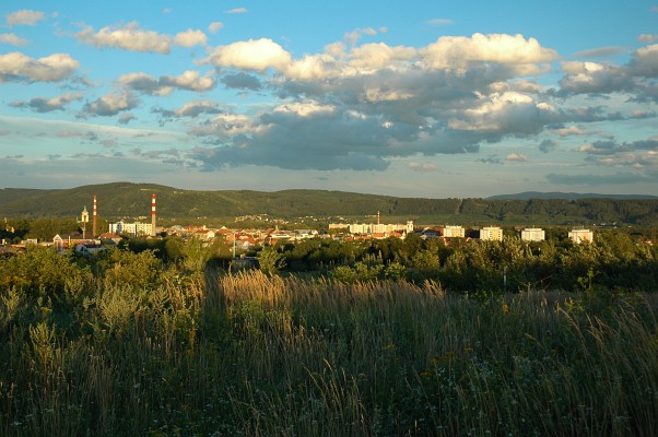
Úvodní souradnice Vás zavedou ke Kapli Nanebevzetí Panny Marie. Finální souradnice vypocítáte pomocí jednoduchého vzorce. Celková trasa je dlouhá okolo 6 km a na kole trvá približne 30 minut.
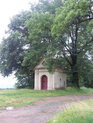
1.Stage: Kaple Nanebevzetí Panny Marie
Souradnice: N 49°31.680, E 017°36.015

Kaple Nanebevzetí Panny Marie zvaná Na spravedlnosti. V techto místech bývalo poslední rozloucení odsouzeného na smrt. V poli proti kasárnám v Hranické ulici je kríž, udávající približné místo popravište, které se nacházelo v blízkosti staré cesty do Hranic.
Pocet všech velkých stromu rostoucích v blízkosti kaple, v okruhu 30m, započítejte i jeden pařez? -> AB
2.Stage: Kaple sv. Josefa
Souradnice: N 49°31.653, E 017°35.352
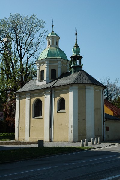
Rane barokní stavba z r. 1695 v sousedství pošty. Témer identické rešení klenby kaple sv. Josefa s architekturou kaple sv. Josefa Kalasanského u piaristického kostela ji vrazuje do tvurcího okruhu G. P. Tencally, autora prestavby kostela sv. Františka Serafinského. V interiéru kaple nás zaujme hlavne kopule zdobená freskami.
Kaple sv. Josefa byla postavena za dekana Jirího Balšánka, který se zasloužil i o vybudování chudobince sv. Alžbety vedle této kaple (dnes je zboren), kaple sv. Petra na hrbitove, rozšírení kaple P. Marie a zbudování kaple sv. Barbory ve farním kostele a také nechal postavit v r. 1694 mariánský sloup na námestí. Mezi lidmi kolovala povest, že našel na fare pod hromadou kamení poklad, zlaté mince, které pak vynaložil na výstavbu všech výše uvedených památek.
Na tabulce popisující kapli je jediný letopocet ve tvaru? -> 1C9D
3.Stage: Kaple sv. Petra
Souradnice: N 49°31.733, E 017°34.991
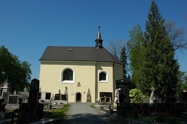
Kaple sv. Petra se nachází na mestském hrbitove. Kaple byla vystavena r. 1688 na hrbitove ležícím mimo hradby, hrbitov byl založen na konci 16. století. Kaple byla puvodne vybavena hlavním a dvema bocními oltári, obrazy Krížové cesty, varhanami, v 70. letech 20. století však došlo pod záminkou rekonstrukce interiéru (nové obklady a osvetlení) k odstranení posledních zbytku puvodního vybavení, vcetne puvodních omítek a maleb. Uvnitr kaple jsou umísteny tri náhrobní kameny z konce 17. století, zvenku na jižní stene je umísteno dalších 9 náhrobku z 18. – 20. století. Kaple prošla v letech 2001 – 2004 kompletní rekonstrukcí, slouží jako smutecní obradní sín.
Na tabulce popisující kapli je jediný letopocet ve tvaru? -> 1698, 16E8
Pozor hrbitov není otevren 24 hod. denne !
Otvírací doba:
od 1.4. do 10.11. a od 20.12. do 27.12. -> 6:30 – 21:00 hod.
od 11.11. do 19.12. a od 28.12. do 31.3. -> 6:30 – 17:00 hod.
4.Stage: Kaple sv. Rocha
Souradnice: N 49°31.563, E 017°34.865
Osecká ulice, kaple byla postavena na památku morové epidemie r. 1716, které padlo za obet 145 osob.
Na tabulce popisující kapli jsou tri letopocty, nás zajímá ten poslední tretí letopocet, ten je ve tvaru? -> 178F
5.Stage: Kaple sv. Anny
Souradnice: N 49°31.937, E 017°34.051
Postavena r. 1699. Nejvyšší bod mesta, 286 m n.m., je odtud vynikající rozhled do celého údolí Moravské brány.
Letopocet na vodojemu v blízkosti kaple je ve tvaru? -> 19GH
6.Final
Souradnice:
N 49° GA.EGB (kde soucet techto peti císel je 17)
E 017° G(F/H).(A-B)CD (kde soucet techto peti císel je 18)
-------------------------------------------------------------------------------------
(ENGLISH)
The first coordinates will lead you to the Chapel of Assumption of Virgin Mary. You will get the final coordinates by a very easy formula. This track is approximately 6 km long and should take you 30 minutes by bike.
1.Stage: The Chapel of Assumption of Virgin Mary
Coordinate: N 49°31.680, E 017°36.015
The Chapel of Assumption of Virgin Mary is also called 'On the Justice'. This used to be a place to say one last good-bye to a person sentenced to death. There is a cross in the fields opposite the Hranicka street barracks which tells us roughly where used to be a place of execution. This was very close to the old road to Hranice.
Question: What is the number of all big trees growing near the chapel, include stump? -> AB
2.Stage: St. Joseph´s Chapel
Coordinate: N 49°31.653, E 017°35.352
An early baroque building from 1695 close to the post office, which was built under
Dean George Balšánek who was credited with building the St.Ann´s poorhouse adjacent to this chapel (It has been pulled down.), with building up the St. Peter´s cemetery chapel and with a column of the Virgin Mary in the Square in 1694.
The chapel interior includes wall paintings from the 18th Century.
Question: What is the date on the table describing the chapel? -> 1C9D
3.Stage: St. Peter´s Cemetery Chapel
Coordinate: N 49°31.733, E 017°34.991
dates from 1698. Old grave stones are set into its wall. It is now under reconstruction as a ceremonial hall.
Question: What is the date on the table describing the chapel? -> 16E8
Attention the cemetery isn´t open 24 hours a day!
The opening hours are:
from 1.4. till 10.11. and from 20.12. till 27.12. -> 6:30 – 21:00
from 11.11. till 19.12. and from 28.12. till 31.3. -> 6:30 – 17:00
4.Stage: Rochus Chapel
Coordinate: N 49°31.563, E 017°34.865
in Osecká Street is a memorial of the plague in 1716, which claimed 145 victims.
Question: On the table describing the chapel, there are three dates, what is the last date? -> 178F
5.Stage: St. Anna´s Chapel
Coordinate: N 49°31.937, E 017°34.051
It was built in 1699. With its 286 metres above the sea level it is the highest point of the town. There is an excellent view over the Moravian Gate valley.
Question: What is the date on the water tower close to the chapel? -> 19GH
6.Final
Coordinate:
N 49°GA.EGB (and the sum of these five numbers is 17)
E 017° G(F/H).(A-B)CD (and the sum of these five numbers is 18)