The Potomac River flows into the Chesapeake Bay, located
along the mid-Atlantic coast of the United States . The river is
approximately 383 statute miles (665 km) long, with a drainage area
of about 14,700 square miles (38,000 km²). In terms of area, this
makes the Potomac River the fourth largest river along the Atlantic
coast of the USA and the 21st largest in the USA. Over 5 million
people live within the Potomac watershed.
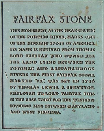
The Potomac River runs from the Fairfax Stone in West Virginia
to Point Lookout, Maryland. The average flow is 10,800 ft³/s (cubic
foot per second). The largest flow ever recorded on the Potomac at
Washington, D.C. was in March 1936 when it reached 425,000 ft³/s
(cubic foot per second). The lowest flow ever recorded at the same
location was 600 ft³/s (17 m³/s) in September 1966. An average of
approximately 486 million gallons of water per day (21 m³/s) is
withdrawn daily in the Washington area for water supply.
The river has two sources. The source of the North Branch is at
the Fairfax Stone located at the junction of Grant Tucker, Preston
counties in West Virginia. The source of the South Branch is
located near Hightown in northern Highland County, Virginia. The
river's two branches converge just east of Green Spring in
Hampshire County, West Virginia to form the Potomac.
The Tidal or Lower Potomac River lies below the fall line. This
stretch encompasses the Potomac from about one mile (2 km) below
the Washington DC-Montgomery County, MD line, just below the Little
Falls of the Potomac River where the tidal river begins, to the
Chesapeake Bay. The Potomac River brings together a variety of
cultures throughout the watershed from the coal miners of upstream
West Virginia to the urban residents of the nation's capital and,
along the lower Potomac, the watermen of Virginia's Northern
Neck.
Tides are caused by the gravitational interaction between the
Earth and the Moon. The moon’s gravitational attraction
causes the oceans to bulge toward the moon with another bulge
occurring on the opposite side. Since the earth is rotating while
this is happening, two large tide events happen each day.
What happens when you mix salt water and fresh water from
streams and rivers? You get an estuary – a fascinating and
important transition zone between land and sea. Estuaries are found
in sheltered bays, inlets, and lagoons where freshwater rivers and
streams meet and mix with the salt water, forming a melting pot of
organic and mineral nutrients. The nutrient-rich soup of the
estuary nourishes plankton and plants, which in turn, nourish
oysters, clams, crabs, and birds.
The Chesapeake Bay is the largest estuary in the United States.
Numerous tidal freshwater sub-estuaries ring the upper reaches of
the Chesapeake Bay and its tributaries, which are sites of active
sedimentation and bayhead delta development. The Potomac River is
one of its many sources to this estuary. Freshwater runoff from
hills and creeks makes its way to the river and dilutes its
salinity, creating an estuary containing a nutrient soup ideal for
growing plankton, the base of the food chain. Estuaries also
provide transitional places for young fish to adjust to
ocean’s salinity. Twice daily, tidal rhythms pull waters in
and out of the river. The word “estuary” comes from the
Latin word “aestus,” meaning tides.
An amazing diversity of shellfish and fish , contributing to a
complex food web exist within the river. Microscopic larvae from
crabs, clams and other shelled animals swim with other zooplankton
and feed on tiny plants called phytoplankton. These plankton
nourish mussels, ghost shrimp, marine worms and other animals that
feed by filtering estuarine waters. Larger animals such as moon
snails and crabs scavenge the mud for these smaller animals. These,
in turn, serve as an important food source for birds and other
predators such as us.
Estuaries are defined as semi-enclosed coastal bodies of water
that have a free connection with the sea and within which seawater
is measurably diluted by fresh water. The fresh-water sources for
most estuaries are streams, rivers, and even groundwater for some
areas. Water circulation characteristics may also be used to
classify different types of estuaries. The movement of water in
estuaries is regulated by the ebb and flow of tides; differences in
the density of water; and wind. Because most estuaries are
influenced by lunar tides, the once-daily (diurnal) or twice-daily
(semidiurnal) rise and fall of water results in a net flow out of
the estuary. In the strictest sense, estuarine circulation usually
refers to the residual water movement after the short-term tidal
effects are removed. Thus, circulation is the time-averaged current
in an estuary and is sometimes described as net current, nontidal
flow, or tidal residual.
Each estuary is unique with respect to physical, chemical, and
biological characteristics, but estuaries share many common
features. For example, rivers provide a continuous input of
sediment into the estuary. Turbidity is a measure of the amount of
suspended particles, which includes fine sediments, in the water.
Circulation within the estuary redistributes the suspended sediment
and a turbidity maximum usually is located in the region of the
estuary where fresh water from the rivers contacts the more saline
coastal waters.
Chemical interactions between the sediment particles and
dissolved ions in seawater result in an attraction between
particles that causes the particles to stick together (flocculate).
The heavier and larger particles settle out of the water column and
are deposited on the bottom. Over time, these deposits may fill
navigation channels.
In summary, estuarine habitats benefit us because:
- they create a rich nursery environment for fish and other
species. Tens of thousands of birds, mammals, fish, and other
wildlife rely on estuarine habitats to live, feed, and
reproduce.
* acre for acre, they are among the most biologically productive
ecosystems on earth.
* they serve as buffers, protecting shorelines from erosion and
flooding.
* they filter pollutants, improving water quality.
To log this Earth Cache email the answers to the following
questions:
1. What was the water level at the time of your visit at this spot
- high or low?
2. What evidences of wildlife did you observe?
3. Do you see any estuarine habitats?
4. What causes tides?
5. What two forms of erosion control are easily seen?
6. Post of picture of you or your GPS at the posted
coordinates