Eschbacher Klippen EarthCache
-
Difficulty:
-

-
Terrain:
-
Size:  (not chosen)
Related Web Page
Please note Use of geocaching.com services is subject to the terms and conditions
in our disclaimer.
 Deutsch:
|
|
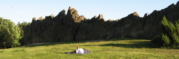
Die Eschbacher Klippen sind Teil des Usinger Quarzgangs, der im
Gelände über eine Länge von 6 km verfolgt werden kann. Die
Mächtigkeit des Ganges beträgt bis zu 80m, d.h. er ist wesentlich
breiter als die hier zu sehenden Felsen. Entlang einer Störung
stießen heiße wässrige Lösungen auf aus denen zuerst das Material
Schwerspat (BaSO4) ausgeschieden wurde. Der Schwerspat
wurde später durch das Mineral Quarz (SiO2) ersetzt. Die
schwarzen und braunen Abscheidungen auf Spalten und Klüften
bestehen aus Eisen- und Manganoxiden/hydroxyden. Der Gang entstand
vor etwa 270 Millionen Jahren, d.h. er ist jünger als die
Gebirgsbildung des Taunus vor etwa 320 Millionen Jahren. Durch die
hohe Verwitterungsbeständigkeit von Quarz ist der Gang im Gelände
häufig als Wölbung zu erkennen, die beständigsten Bereiche des
Ganges sind als Felsen erhalten.
Um den Cache als Fund zu loggen bitte eine eMail an mich mit der
Antwort auf folgende Fragen:
a) Wie nennt man die Gesteinsformation rechts neben dem
gewöhnlichen Gangquarz (siehe Informationstafel) ?
b) Welche Höhe haben die Eschbacher Klippen (diese Information
findet Ihr nicht vor Ort, also schätzt Ihr am besten oder nutzt das
Internet) ?
Optional: Wenn möglich hängt bitte eine Foto an das Log welches
Euch mit dem GPS in der Hand vor/auf den Eschbacher Klippen
zeigt.
Nachdem Ihr Eure Antworten geschickt habt
könnt Ihr Euren Besuch sofort online loggen (wartet nicht auf meine
Bestätigung). Sollten Eure Antworten nicht korrekt sein dann melde
ich mich schon, Logs ohne Mail mit den Lösungen muss ich leider
wieder löschen.
|
 English:
|
|
The Eschbacher Klippen are Part of the Usinger quartz channel which
can be traced in the area for about 6 km. The thickness of such a
channel is about 80m; this means it’s broader as you can see
on the rocks here. Along a pertubance hot aqueous solution reached
the top and released barium sulfate (BaSO4). The barium
sulfate was later replaced by quartz (SiO2). The black
and brown separations on splitting and fissures are composed of
iron- and manganese oxide/hydroxide. The channel was formed about
270 million years ago; this means it’s younger than the
orogenesis of the Taunus about 320 million years ago. Due to the
high weathering resistance of quartz you can see it as a bulge
often in the area; the resistant parts of the channel are preserved
as rocks.
To log your find please answer me the following (by email) you can
find the information for a) on the information panel:
a) What the name of the structure on the right side of the ordinary
quartzchannel ?
b) What’s the height of the “Eschbacher Klippen”
(this information cannot be found there, just estimate the height
or use the Internet) ?
If possible please attach a picture of you, you’re GPS taken
with the Eschbacher Klippen in the background to proof you visited
the site.
You can log immediately your visit online
after having sent the answers. It is not necessary to wait for my
confirmation as I'll contact you in case there are errors in your
answers. Should you log without sending me an answer I'll have to
delete your log.
|

Additional Hints
(No hints available.)