This location now requires reservations which are available at Glenwood Springs Website
This EarthCache is designed to highlight a few spectacular features of Dead Horse Creek in the White River National Forest. We will be looking at Hanging Lake and Spouting Rock.
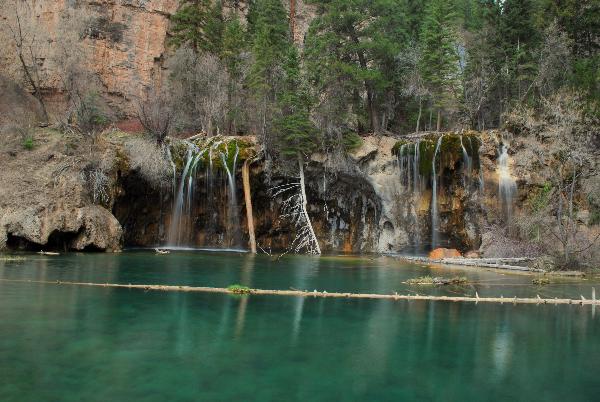
Hanging Lake is located in Dead Horse Canyon a side canyon of Glenwood Canyon along Dead Horse Creek, a tributary of the Colorado River. The lake was formed by a fault that caused the lakebed to drop away from the valley floor above. From here the rest of the work was done by the mineral-laden waters of Dead Horse Creek. The shoreline is composed of travertine deposited on the rocks and logs.
Travertine is a sedimentary rock which forms as calcium carbonate is deposited from water that is saturated with calcium bicarbonate. In this location the travertine is created by the dissolved limestone of the Mississippian Leadville Formation picked up when Dead Horse Creek flows through it.
Limestone (calcium carbonate) is slightly soluble in water, similar to the way salt dissolves in water. When the water contains carbon dioxide it forms a weak acid, called carbonic acid. The addition of carbon dioxide greatly increases the solubility. A small amount of carbon dioxide is found in rainwater and it picks up even more as ground water when it infiltrates through the soil. It picks up this additional carbon dioxide from decaying organic matter and plants. In this way the water passing through the soil and into the underlying rocks has the capacity to dissolve limestone.
Many of the rocks in the area are layered and there are many cracks and fractures in them. Ground water trickling through the soil moves into and along these cracks. The ground water begins to dissolve the surface of the rocks exposed through these cracks. It is through this slow process that passages and large caverns are made. Water moving through soluble rock will continue to dissolve it until the water becomes saturated with calcium and carbonate ions.
Eventually these solution cavities grow until the unsupported ground surface collapses forming a sink hole. Sink holes act as giant funnels greatly increasing the amount of ground water entering the underground system. Sometimes surface streams are diverted underground through openings known as swallow holes. It is possible for entire rivers to enter the solution passages in this way. All water infiltrating the ground moves rapidly downward until all passages and cracks are filled at a saturation point know as the water table. Water below the top of the water table continues to circulate but it is much slower moving than through the cracks and spaces above it. Finally this water will reappear at a lower elevation on the ground surface, in this case, at Spouting Rock. Spouting rock is the feeder for Hanging Lake. It is a waterfall spouting directly from the face of a cliff. Below the waterfall is a shallow "cave" which was created through the erosional force of the back-splash of the waterfall.
All along the creek you will see the travertine hanging off of the wall above the lake, forming the downstream shoreline of the lake, and seeming to "cement" all of the rocks along the stream together all the way down to the confluence at the Colorado. This travertine is composed primarily of calcium carbonate, the mineral calcite. Calcite is deposited by groundwater saturated with the calcium and carbonate ions. This is mainly the result of the loss of carbon dioxide into the air. Saturation may also take place when the water evaporates.
Here's the chemical formula representing the dissolved mineral calcite precipitating out of the water:
Ca(HCO3)2 --> CaCO3 + H2O + CO2
This can also be represented as:
calcium bicarbonate --> calcite + water + carbon dioxide.
Travertine is often used as a building material. It is one of several popular natural stones that are used for countertops, flooring tiles, paving patios, and garden paths. The largest building in the world constructed mostly of travertine is the Colosseum in Rome. Other notable buildings using travertine extensively include the Sacré-Cœur Basilica in Paris and the Getty Center in Los Angeles, California.
Plan on spending at least 2 hours here and be sure to bring a camera for the breathtaking views of over a dozen waterfalls, Hanging Lake, Spouting Rock, Colorado River, and the towering amphitheaters of both Glenwood and Dead Horse Canyons.
The trailhead is a bit tricky to find. The trailhead is located at a rest area only accessible from eastbound I-70. If you are traveling westbound on I-70 you must pass Hanging Lake and exit at the Grizzly Creek. At Grizzly Creek exit the interstate, turn left, and immediately turn left again onto I-70 eastbound. You will then get off at the Hanging Lake Exit, park at the rest area, and then follow the paved path along the Colorado River to the trailhead. The total hike will be just shy of 3 round-trip miles with an elevation gain of just over 1,000 feet. The trail is rocky but well marked. When you come to the sign for the Dead Horse Trail make sure you follow the arrow to Hanging Lake. The last tenth of a mile or so is a bit steeper but there are handrails and finally you will have to go some steps carved into the rock. This section has some dangerous drops but nothing too bad and again a handrail is provided. Once at the top of the steps you are reach the boardwalk along the lake. As you head back toward the "steps" you will see the sign for Spouting Rock on your right. Follow this short trail to the level above the lake to find Spouting Rock. The return to your car will be the same way back down. This trail does have the potential to be very dangerous in icy conditions and though a visit in winter can be very rewarding be honest with yourself about your abilities and use common sense in deciding to go on or not. Likewise in warm months you will need to remember to bring water because this is a moderately strenuous hike.
Parking Area - N 39 35.364 W 107 11.425
Trailhead - N 39 35.559 W 107 11.058
To claim this as a find:
1. Post a photo of yourself and your GPS with Hanging Lake in the background. (Optional but appreciated)
2. Post a photo of yourself and your GPS with Spouting Rock in the background. (Optional but appreciated)
3. What creates and renews the shore around the lake?
4. How many acres is the lake?
5. Estimate the distance the water is dropping into the lake?
Not sure who started it but please DO NOT go out on the log.
From this point on (10/19/09) I will just delete find logs from anyone I find out does this.
E-mail the answers to me for numbers 3, 4, and 5 and post the photos with your log within a few days.
Good luck and good caching.
- Rev Mike