Emerald Pool EarthCache
-
Difficulty:
-

-
Terrain:
-

Size:  (other)
Please note Use of geocaching.com services is subject to the terms and conditions
in our disclaimer.
On the Volcanic Island of Dominica in the heart of the rain forest in Morne Trois Pitons National Park. Dominica is one of the filming sites for Pirates of the Caribbean movies and is an incredible location.
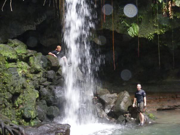
Emerald Pool is a popular tourist destination whether one travels to the island by cruise ship or otherwise. Several tours are shuttled to the site or it is easy to have a taxi take you there independently. Entrance into the park is US$5.00 and is a short hike to the falls. It is rumored that if you swim in the Emerald Pool is will take 10 years off of your life (I mean to say, it will ADD 10 years to your life haha...thanks to dcachfinder for pointing out that was worded backwards.) Dominica is an island born of volcanic origins and is shown by many different types of geologic formations all over the island and rain forest. There is a lot of flora and fauna and different species of animal life in the rain forest as well. The water of emerald pool runs through a volcanic canyon and over into a grotto. There is a cave that is behind the falls and one can walk behind the falls without getting wet if you prefer. Lava can be dynamic and can create many unusual types of formations, particularly caves.
Dominica lies at the center of the Lesser Antilles Island arc, where the islands of the Active Arc (see Lesser Antilles Arcs map on this website) are large and complex comprising many coalesced stratovolcanoes. The island has an area of 750 sq.kmWhereas all the other volcanic islands of the Lesser Antilles have only one active volcano, Dominica has nine and yet there has been no major magmatic eruption since Columbus visited the island and as a result it has today the best and most extensively preserved tropical rainforests. The youngest dated volcanic deposits on the island are associated with the Morne Patates dome on the flanks of the large active Plat Pays Volcano that comprises the southwestern end of the island. This was a Pelean eruption (similar to the eruptions of Mt. Pelee on Martinique in 1902 and 1929) and radiocarbon ages from the block and ash deposits suggest it occurred about 500 years ago. In addition there have been two steam explosions (phreatic activity) in the Valley of Desolation in 1880 and 1997. Frequent seismic swarms and vigorous and widespread geothermal activity today characterize the island. In fact it is the most worrying of all the Caribbean volcanic areas and there is a general feeling that it (like Montserrat pre-1995) is long overdue for an eruption. What is of particular concern is that the capital Roseau and most of the islands infrastructure lie on a pyroclastic flow fan derived from the Wotten Waven caldera situated on the eastern outskirts of the capital. The pyroclastic deposits of the Roseau area abound with ignimbrites (pumiceous pyroclastic flows), surge and airfall deposits with radiocaron ages ranging from 38,000 to 1000 years B.C. (from Wikipedia) There are numerous types of lava caves, the most common and most extensive being lava tubes. But not all lava caves are lava tubes. Other types of lava caves include the following classifications: * Volcanic rift or fissure caves, which form along volcanic rift zones and eruptive fissures, or in fractures associated with volcanic activity. These are tectonic in formation, caused by “stress in lava during and after solidification.” They may also be the site of fissure eruptions, and the walls covered with spatter. Notable rift caves include Crystal Ice Cave, formed in Idaho’s Great Rift (and now part of Craters of the Moon National Monument and Preserve). Caves in the Great Rift are known up to 800 feet deep. * Inflationary caves tend to be small chambers which form when lava under pressure pushes up surface rock from below and then drains back down. One surface expression of this is the tumulus, a fractured hillock of lava which is often hollow. In some cases volcanic gases may exert pressure on solid or semi-solid lava and form what is basically a bubble of thin rock. Rarely, the latter may be big enough to qualify as a cave. * Lava mold caves, which form when lava flows around trees or even large dead animals. The engulfed material eventually burns or decays away, but ends up leaving a hollow space with the original shape. Usually these are not very large but can get somewhat complex where groups of fallen logs were touching, and may then form caves that go in several directions where the resulting voids intersect. Such caves are known from Washington (USA), near Ape Cave, and from most notably from Japan in the Yoshida-tanai area. Elephant mold caves are known from the Nyiragongo volcano in Africa, and one in the shape of a Tertiary-age Rhinoceros is known from Blue Lake, Washington (USA). * Open vertical volcanic conduits are voids open to the surface which remain after magma has erupted. They tend to be narrower near the top and bell out below, requiring a roped descent for exploration. The deepest known example is Thrinukagigur in Iceland at 204m deep. * Pit craters form when magma that doesn’t quite reach the surface drains to form a void, and the ground above it slumps. These huge open-air pits with their sheer walls are analogous to some of the large shafts formed by solution, and typically require a roped descent for exploration. While most have no extension beyond the visible floor, others may have entrances into adjacent (now empty) magma chambers, such as was seen when the crater of Mauna Ulu in Hawai`i Volcanoes National Park was explored by a team of Swiss cavers. In Na One, a pit crater on Hualalai Volcano in Hawaii, a narrow opening at the bottom of an 130m-deep pit crater leads into an open vertical volcanic conduit, with a total depth of 268 m.
Logging Requirements:
1. Name what kind of cave the falls runs over.
2. photo of yourself at the falls to verify location.
Additional Hints
(No hints available.)