Vor etwa 200.000 Jahren, während der Saalekaltzeit, breiteten sich gewaltige Eismassen von Skandinavien ausgehend über das heutige Norddeutschland aus. Im sogenannten
Drenthestadium dieser Eiszeit erreichten die Gletschervorstöße mit ihrer maximalen Südausdehnung (gepunktete Linie unten) die Ruhr. Die Gletscher führten über tausende von Kilometern Gestein mit sich, das sie beim Abschmelzen schließlich absetzten. Heute findet man diese Gesteinsbrocken daher an Stellen, an denen der jeweilige Gesteinstyp eigentlich nicht vorkommt. Bei größeren Blöcken spricht man von
Findlingen oder
Erratischen Blöcken (von lat.
errare = irren).
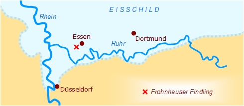 Das heutige Ruhrgebiet während des Drenthestadiums der Saalekaltzeit
Während der Ausschachtungsarbeiten zur A40 wurde im Essener Stadtteil Frohnhausen ein mehr als 7 Tonnen schwerer Granitblock gefunden, dessen Zusammensetzung auf eine Herkunft in Mittelschweden schließen lässt. Aufgrund seiner Größe wurde er zum Naturdenkmal erklärt und vor dem Gebäude der Realschule Essen-West in unmittelbarer Nähe zum Fundort öffentlich ausgestellt. Eine Informationstafel existiert vor Ort leider nicht; so soll dieses EarthCache-Listing auch dazu dienen, die verfügbaren Daten der Öffentlichkeit zugänglich zu machen.
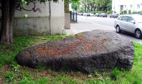 Der Findling neben dem Eingang der Realschule Essen-West
Petrografische Daten für Experten:
Gesteinstyp: Revsund-Granit. Grundmasse: Quarz (grau), Alkalifeldspat (weiß bis schwach rosa), Plagioklas (weiß), Biotit (schwarz), Hornblende (schwarz-grünlich), mittel bis grobkörnig. Einsprenglinge: leistenförmige Alkalifeldspäte (weiß) sind eingeregelt. Erscheinungsbild: Der Findling ist an den Kluftflächen durch die Oxydation des Eisens (Hämatit) stark verwittert; der Granit ist grobkörnig; der graue Quarz ballt sich um die Mikrolin-Kristalle zusammen und der Biotit bildet Fasern, die sich den Mikrolin-Kristallen anschmiegen.
Quelle der petrografischen Daten: Claudia Bergrath, Dirk Schnell: Die Findlinge im Essener Stadtgebiet - Ihre Herkunft, Schutzwürdigkeit und Präsentation, Universität Essen, 1998. Mit freundlicher Unterstützung der Unteren Landschaftsbehörde Essen sowie des Geologischen Dienstes NRW. Foto und Grafik: geotb.
Bedingung für die Logerlaubnis
Beantworte die folgenden vier Fragen und sende mir deine Antworten per E-Mail (über das Kontaktformular in meinem GC-Profil). Du kannst dann sofort loggen, ich werde mich melden, wenn etwas nicht stimmt. Fotos sind natürlich willkommen, werden aber nicht ausdrücklich zur Bedingung gemacht.
Frage 1: Der Findling hat annähernd Keilform. In welche Richtung weist seine Spitze? Wähle zwischen NW, N und NO.
Frage 2: Wie groß ist seine Ausdehnung in Längsrichtung (gerundet) in Metern?
Frage 3: Woher stammt das Gestein ursprünglich?
Frage 4: An der Wand des Schulgebäudes hinter dem Findling befindet sich ein gelbes Gas-Hinweisschild. Wie lautet die zweistellige Zahl vor dem Komma unten auf dem Schild?
Glacial Erratic in Frohnhausen
About 200.000 years ago, during the Saalian ice age, enormous masses of ice originating from Scandinavia spreaded over today's North Germany. In the so called
Drenthe stage of this ice age the glaciers advanced to their southern maximum (dotted line below) and reached the river Ruhr. Glaciers carried rocks over distances of thousands of kilometers and deposited them when they retreated. Today such rocks are found at places where they differ from the size and type of rock native to the area in which they rest. (
Erratics take their name from the latin word
errare = to err.)
 Today's Ruhr area during Drenthe stage of Saalian ice age
During excavation work for Highway A40 in Essen-Frohnhausen a more than 7 tons granite boulder was found, the composition of which suggests its origin in Middle Sweden. Due to its size it was declared a Natural Monument and exhibited publicly in front of the building of secondary school Essen-West, close to where it was found. Sadly, there is no information panel at the site; hence the purpose of this EarthCache listing also is to provide available facts to the public.
Erratic boulder next to the entry of secondary school Essen-West
Petrographic data for experts:
Type of rock: Revsund granite. Matrix: quartz (grey), alkali feldspars (white to light pink), plagioclase feldspars (white), biotite (black), amphibole (black-greenish), middle to coarse-grained. Inclusions: alkali feldspars (white). Appearance: At the joints the boulder is highly wheather-beaten due to the oxydation of iron (hematite); the granite is coarse-grained; the grey quartz conglomerates around the microcline crystals and the biotite forms fibers that huggle against the microcline crystals.
Source of petrographic data: Claudia Bergrath, Dirk Schnell: Die Findlinge im Essener Stadtgebiet - Ihre Herkunft, Schutzwürdigkeit und Präsentation, University of Essen, 1998. With kind support by Untere Landschaftsbehörde Essen and Geologischer Dienst NRW. Photo and diagram: geotb.
To log this EarthCache
Answer the following four questions and send me your answers throught the contact form in my GC profile. You may log at once, I'll contact you if something is wrong. Photos are welcome but not formally required.
Question 1: The boulder is approximately wedge-shaped. In which direction points its head? Choose NW, N or NE.
Question 2: What is the largest extension (rounded) of the boulder in meters?
Question 3: What is the origin of the stone?
Question 4: There is a yellow gas indicator sign on the wall of the building behind the boulder. What is the two-digit number before the comma at the bottom of the sign?