|
   |
|
|
| Map |
 |
| Budapest |
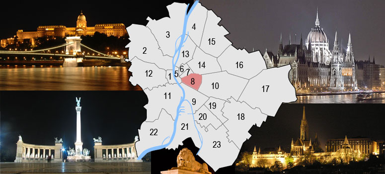
Budapest is a city of multiple characters, different geographical areas and of wide variety of architectural styles. The current city was established on 17th November, 1873 by the unification of the settlements of Pest, Buda and Óbuda on the banks of the Danube river. Budapest had 10 districts after coming into existence in 1873, numbered 1 to 10. In the 1930s, 4 new districts were organized, numbered 11 to 14. On 1st January, 1950, Budapest was united with 7 neighbouring towns and 16 villages, hence the number of its districts increased to 22. In 1994, one of the former villages left district 20 in order to form the 23rd district. Budapest's current 23 districts extend to an area of 525 square kilometres (202.7 sq mi). Most of the districts have a special flavour - from a posh downtown area one can get easily into the hilly districts of Buda or to the green suburbs of Pest. Several districts still bear the marks of the enforced industrialization of the 50s and 60s. City parks, forests of the Buda Hills, boat-houses along the Danube, flowery islands, shipyards and chemical plants, the Royal Castle and prefab housing estates are all part of this wonderful city.
The Great Budapest Geocaching Adventure guides you through all 23 districts with the goal of displaying the most typical or most unique sites in each of them. In each cache there is a code you need to uncover for the real coordinates of the bonus cache. You can find the codes on the inside of the lids of each cache container and in the logbooks. Happy caching. |
| 8th district |
| Today's Józsefváros started in the 1720 years to become peopled. Many buildings were destroyed in the flood of 1838. A considerable reconstruction was beginning after the flood, the streets with a townish character and public buildings started taking it’s shape at this time. The immigration was began to grow together with the growing of the traffic (1866 horse tramway, 1899 electric tramway) and the growing of the industry. The population of the district rised to 91.303 in the year of 1890. It was the 18,8% of the full population of the capital. The building in of the district and the top of the population was int he year of 1910 (164.255 resident) After the World War I. the home-building totally ceased because of the destitution and the weak economy of the country. In World War II. the 90% of the buildings of Józsefváros were destroyed. The reconstruction progressed very slowly. Here can be found some part of the centres of the public works serving of the capital's function. The traffic by virtue of the quarter's central position is well built up. Budapest's most considerable public transport lines are due on the main roads of the district. |
 |
|
|
| The hiding place |
The Orczy Forum
In the VIII.-th. district of Budapest has been built a new city centre, called Orczy Forum. The centre's planning began with the urban redevelopment planning in 1990 then following this based on a Swiss investor's commission in the same year.The original plan was a 5 star hotel with 400 rooms on the empty field of Baross street 135. but it did not come true about financial problems. The centre is built on this plot with the partial use of the foundations of this building. It was the ninth and the last building with 160 flats. In the end of the 1980 years there were some industrial buildings too beside the poor conditioned houses, they has been bought by investor companies wich were built under nine period of the today face of the Orczy Forum. The original plan was an office and a merchant building with a parking garage (today Orczy square 1-4) and a hotel with 400 rooms. This makes today the main, inner building. Then later a shopping centre wich remain only a plan. The functions of the buildings were changed with the passing years, the new conceptions made the present-day status of the Orczy Forum.
The whole ground of the centre is: 17.250 m2
The gross built-in area of the centre: 63.540 m2 |
| Approaching |
 From Deák Ferenc tér by bus 109 (8 stops - Orczy tér) or from Blaha Lujza tér by bus 99 busz (7 stops - Orczy út) by tram from Nagyvárad tér with tram 28 villamos (3 stops - Orczy tér)(visit link). From Deák Ferenc tér by bus 109 (8 stops - Orczy tér) or from Blaha Lujza tér by bus 99 busz (7 stops - Orczy út) by tram from Nagyvárad tér with tram 28 villamos (3 stops - Orczy tér)(visit link).
 Unfortunately there are no bikeroad in this district (visit link) Unfortunately there are no bikeroad in this district (visit link)
 Free parking at: 47 29.331 / 19 05.538 coordinates, see them at waypoints. Free parking at: 47 29.331 / 19 05.538 coordinates, see them at waypoints.
|
| Budapest |
| Budapest ist eine Stadt bunten Charakters, unterschiedlicher geographischer Zonen und einer breiten Vielfalt an architektonischen Stilen. Die heutige Stadt wurde am 17. November 1873 durch Zusammenschluss der Städte Pest, Buda und Óbuda, die an beiden Ufern der Doanu liegen, gegründet. Budapest hatte damals 10 Bezirke, nummeriert von 1 bis 10. In den 30er-Jahren kamen 4 weitere Bezirke (11-14) hinzu. Am 1.Jänner 1950 wurde das Stadtgebiet um angrenzende 7 Städte und 16 Dörfer erweitert, die Zahl der Bezirke erhöhte sich damit auf 22. 1994 wurde eines der früheren Dörfer aus dem 20. Bezirk ausgegliedert, womit ein neuer 23. Bezirk enstand. Die derzeit 23 Bezirke haben eine Ausdehnung von insgesamt etwa 525km² (202,7mi²). Die meisten dieser Bezirke haben ihren unverwechselbaren Charakter - von repräsentativen Innenstadtbereichen über die hügeligen Bezirke von Buda bis hin zu den erholsamen grünen Vorstädten von Pest ist alles zu finden. Einige Bezirke stehen bis heute im Zeichen der stark forcierten Industrialisierung der 50er- und 60er-Jahre. Stadtparks, die Wälder der Budaer Berge, Bootshäuser entlang der Donauufer, blütengezierte Inseln, Werften und Chemiebetriebe, die königliche Burg und auch Fertigteil Wohnhausanlagen sind alle Teil dieser wundervollen Stadt. Das Große Budapester Geocaching Abenteuer wird durch jeden der 23 Bezirke führen und versuchen, in jedem etwas Typisches oder Einzigartiges zu zeigen. Jedem, der alle 23 Caches besucht, winkt als Draufgabe ein BONUS-Cache. Happy Caching. |
| 8. Bezirk |
Die Einwohnerung der heutigen Josefstadt fang in 1720 an. Das beherschende Haustyp, die ebenerdige Lehmgebäude wurden von der Flut in 1838 vernichtet. Nach der Flut fang ein bedeutsame Wiederaufbau an, damals began die Entwicklung der städtischen Straßen und öffentlichen Gebäuden.
Ebenmäßig mit der Entwicklung der Werkindustrie, die Einwohneranzahl von Josefstadt hat sich auf 1890 auf 91303 erhöht, die war die 18,8% der gesammten Hauptstadteinwohner. Wegen der Ersten Weltkrieg erfolgende Unvermögenheit und geringe Wirtschaftswachstum wurden mit der Wohnungsbautätigkeiten fast ganz aufgehört. Auf der Hauptstraßen des Bezirks fahren die wichtigste Öffentliche Verkehrsmittels von Budapest. |
|
| Das Versteck |
Orczy-Forum
Die Planung des Zentrums fang in 1990 mit der Stadtplanung an, dann nach dem Auftrag von einem schweizeren Anleger begann die Planung eines Hotels mit 400 Zimmer in der Baross Straße 135, was aber wegen finanzielle Probleme nie zustande gekommen ist. In den originalen Pläne wurden Bürohäuser, Hotel, Einkaufszentrum und Parkhaus vorgestellt.
Das ganze Grundstück beträgt: 17 250 m2
Die ganze eingabaute Fläche ist: 63 540 m2 |
| Verkehrsverbindung |
Vom Deák Ferenc tér mit bus No.:109 (8 anhalten - Orczy tér) oder vom Blaha Lujza tér mit bus No.:99 (7 anhalten - Orczy út) Mit straßenbahn: vom Blaha Lujza tér mit straßenbahn No.: 28 (4 anhalten - Orczy tér)(visit link).
Es gibt nicht offiziellen Fahrradweg leider zum Ziel (visit link)
Das freie parken auf den gewährten koordinaten: 47 29.331 / 19 05.538
|
| Budapest |
| Budapest ezerarcú város, melyet földrajzi változatossága és építészeti sokszínusége varázsol egyedivé. Az 1873. november 17-én Pest Buda és Óbuda egyesítésével létrejött akkori fovárosnak 10 kerülete volt, amely az elkövetkezo évtizedek során fokozatosan bovült a mai 23-ra. A város ma 525 négyzetkilométeren terül el. A különbözo kerületek a folyamatos fejlodés és átalakulás mellett továbborzik sajátosságaikat, a Belváros csillogó bevásárló utcái, Buda dombvidéke vagy a pesti zöldövezet lakónegyedei mind sajátos hangulattal bírnak. A város arcát továbbra is sebhelyként csúfítják az 50-es 60-as évek eroltetett iparosításának "emlékmuvei". Zöld parkok és ligetek, a Budai hegyvidék erdoi, Duna-parti csónakházak, virágos szigetek, hajógyárak és vegyi üzemek, a Budavári palota és panel lakótelepek - ez mind Budapest. A Nagy Budapesti Geocaching Kaland végigvezet mind a 23 kerületen bemutatva az adott városrész legjellegzetesebb vagy éppen a legfurcsább vonását Ha mind a 23 ládát megtalálod, indulhatsz a BONUS csésze megkeresésére. Kalandra fel! |
| 8. kerület |
| A mai Józsefváros az 1720-as években kezdett benépesedni. Az uralkodó háztípust, a földszintes agyagépületeket az 1838-as árvíz elpusztította. Az árvíz után jelentos újjáépítés kezdodött, ekkor kezdtek kialakulni a városias jellegu utcák és középületek. A betelepülés, a közlekedés (1866: lóvasút, 1899: villamosvasút) és a gyáripar fejlodésével volt arányos, Józsefváros lakosainak száma 1890-re 91 303 fore nott, ami a fováros lakosságának 18,8%-át jelentette. A kerület beépítése és a lakosság számának ugrásszeru növekedése 1910 körül (164 255 lakos) érte el csúcspontját Az I. világháború következtében a szegénység és a minimális gazdasági növekedés miatt a lakásépítési tevékenység szinte teljesen megszunt. A II. világháború során a józsefvárosi épületek mintegy 90%-a sérült meg. A fováros muködését szolgáló közüzemek központjainak egy része is itt található. A közlekedés a városrész központi elhelyezkedésénél fogva jól kiépített. A foutakon Budapest legjelentosebb tömegközlekedési vonalai járnak. |
|
|
| A rejtek |
A VIII. kerületben valósult meg az Orczy Fórum új városközpont.
A központ tervezése 1990-ben kezdodött a városrendezési tervezéssel, majd ezt követoen egy svájci befekteto megbízása alapján még ez évben elkezdték a Baross utca 135. számú üres telken egy 400 ágyas szálloda tervezését, mely azonban a befekteto finanszírozási nehézségei miatt az alapozásnál leállt és nem valósult meg. Ezen épület alapjainak részbeni felhasználásával e telken épült meg a központ kilencedik, egyben befejezo 160 lakásos lakóépülete. Az 1980-as évek végén néhány leromlott állagú lakáson kívül ipari jellegu épületek álltak a területen, melyet az évek során a befektetok megvásároltak és az eredeti telekelosztások figyelembevételével kilenc ütemben az új épületekkel beépítették. Az eredeti városrendezési tervben az irodaházak mellett a központ részeként szerepelt még egy 400 ágyas szálloda, egy áruház (késobb egy bevásárlóközpont is), egy kereskedelmi épület és egy parkolóház. Az évek során a Kévés és Építésztársai Rt., mint a központ megvalósításának pénzügyi szervezoje rugalmasan alkalmazkodott az elmúlt 15 év változásaihoz és fokozatosan a városközpont koncepciójának megtartásával változtatta meg az egyes épülettömbök funkcióját és hozta létre a városközpontot.
A központ teljes telek területe: 17.250 m2
A központ bruttó beépített szintterülete: 63.540 m2 |
| Megközelítés |
A Deák térrol 109-es busszal 8 megálló az Orczy térig vagy a Blaha Lujza térrol 99-es busszal 7 megálló az Orczy útig. Villamossal: a Nagyvárad térrol (28 villamos 3 megálló az Orczy térig)(útvonalterv).
Sajnos a kerületben nincs bringaút a célhoz. (térkép)
Ingyenes parkolóhelyek: 47 29.331 / 19 05.538
|