Rheinauen - Haderaue EarthCache
-
Difficulty:
-

-
Terrain:
-

Size:  (other)
Please note Use of geocaching.com services is subject to the terms and conditions
in our disclaimer.
 Earthcache Rheinauen - Haderaue

Die Haderaue ist Teil eines 165 ha großen Naturschutzgebiets am „Inselrhein“ zwischen Mainz und Bingen.
Der Inselrhein [Karte] ist ein Abschnitt des Rheins, in dem der Fluss bedingt durch die Rückstauung des Wassers am Binger Loch [bei N 49° 58' 33", O 7° 52' 22"], wo Quarzitfelsen des Hunsrück und Taunus den Rhein einengen und als natürliche Barriere wirken, eine große Breite (bis zu 1 km) besitzt und das Wasser sehr langsam fließt. Die geringe Fließgeschwindigkeit sorgt für eine Ablagerung von Kiesen und Sanden in diesem Bereich. Da durch die Begrenzung der dem Rhein zur Verfügungen stehenden Fläche durch das Rheinhessische Tafel- und Hügelland (Tertiär) auf der linksrheinischen Seite sowie den Taunus (Devon) rechts des Flusses sich keine Möglichkeit zur Ausbildung von Mäandern bietet, entstanden durch die Kies- und Sandablagerungen im Laufe der Zeit flache Inseln, die Auen.
Auch die Haderaue war bis vor zweihundert Jahren eine dieser Inseln. Sie verlandete jedoch zunehmend und verlor schließlich ihren Inselcharakter.
Logbedingungen:
1. Schickt die Antworten zu folgenden Fragen a) Erklärt mit Euren eigenen Worten, was der “Krappen” ist und warum und wie er entstand.
b) Wann spätestens war der “Krappen” völlig vom Fluss abgetrennt?
c) Die Umrisse der Haderaue sind auch heute noch in der Landschaft gut erkennbar. Wie lang ungefähr ist die ehemalige Insel heute? Diese Frage ist vielleicht ein bißchen kniffliger. Dafür gibt aber mehrere Möglichkeiten, zu einer hinreichend genauen Antwort zu kommen (±100 m ist ok). Auch vor Ort. Eine Karte kann hilfreich sein.
2. Findet die Furt durch den “Krappen” im Südwesten der Haderaue and macht dort ein Foto. Der „Krappen“ soll deutlich zu erkennen sein. Freiwillig: gerne dürft auch ihr, euer GPS, Fahrrad, Maskottchen, usw. auf dem Foto zu sehen sein.
3. Ihr könnt sofort loggen. Hängt an euren Logeintrag das Foto an, aber passt auf, dass euer Text keine Antworten auf die Fragen enthält (auch keine Hilfestellungen). Logeinträge mit Einträgen, die die genannten Bedingungen nicht erfüllen, muss ich leider löschen.
Wenn Ihr euch noch ein wenig in der Umgebung umschauen wollt, könnt ihr ja noch den Bonuscache GC1RANP suchen.
Viel Spaß wünscht geowas!
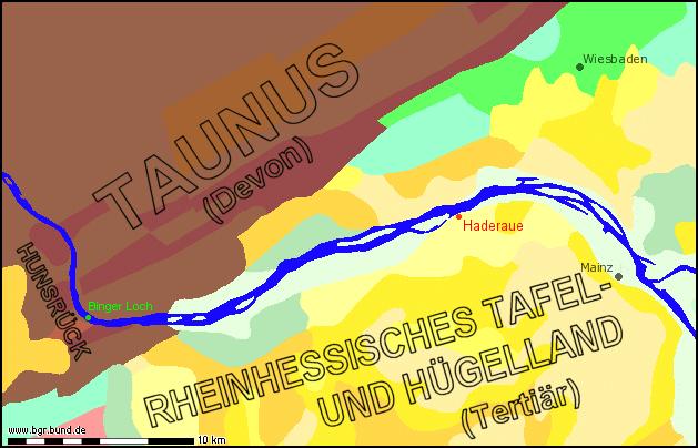

Haderaue is part of a nature reserve of 165 ha in the Inselrhein section of the Rhine river between the cities of Mainz and Bingen.
The Inselrhein [map] is a section of the Rhine where its waters flow with a very low pace and the river has a width of up to one km. This is due to the afflux caused by the hard quartzite rocks of the Hunsrück and Taunus hill ranges at Binger Loch [at N 49° 58' 33", E 7° 52' 22"]. The rock narrows the river and hinders the water’s free flow. The low flowing speed causes a sedimentation of gravel and sands. Normally the river would form meanders in this case. But as the area available to the river is limited here by the hills of Rheinhessisches Tafel- und Hügelland (Tertiary) to the left and by the Taunus (Devonian) mountains on its right, instead islands emerged in the middle of the river: the "Rheinauen".
Also "Haderaue“ was one of these islands still two centuries ago, but it eventually lost its island character due to continuous aggradation.
To log your visit:
1. Send the answers to the following questions to g e o w a s (at) g m x . d e :
a) Explain in your own words what the “Krappen” is and why and how it was formed.
b) When at the latest was the “Krappen” completely detached from the river?
c) The outlines of Haderaue can still be identified if you carefully observe the landscape. What is the approximate length of this former island today? This question is somewhat more tricky. But on the other hand there are plenty of ways to find an adequate answer (±100 m will do). A map can be of help.
2. Find the ford crossing the “Krappen” in the southwest of Haderaue and take a picture there. The "Krappen" should be clearly visible. Optional: It would be cool to see you or your GPSr, your bicycle, mascot, etc. on the picture, too.
3. If your answers are ok, you will receive an e-mail with the permission to log. To your log attach the picture you took. But be careful not to include any answers to the questions above. Early logs (prior to permission) or logs that do not fulfill the requirements I will have to delete.
For cachers who don’t speak German at all and struggle with the questions: Take the picture and tell me as much as you can about the Haderaue floodplain.
If you like to spend some more time at "Haderaue" you are welcome to also find the bonus cache GC1RANP!
Happy caching!
Additional Hints
(No hints available.)